Kendrapara district
Kendrapara District is an administrative district of Odisha state in eastern India. The town of Kendrapara is the district headquarters. Kendrapara District is situated in the eastern portion of the state, and is bounded on the north by Bhadrak District, on the east by the Bay of Bengal, on the south by Jagatsinghpur District, on the west by Cuttack District on the northwest by Jajpur District.
Kendrapara | |
|---|---|
District | |
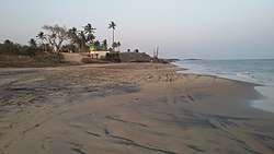 Pentha beach | |
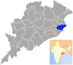 Location in Odisha, India | |
| Coordinates: 20.525°N 86.475°E | |
| Country | India |
| State | Odisha |
| Headquarters | Kendrapara |
| Government | |
| • Collector & District Magistrate | Shri Samarth Verma, IAS |
| • Superintendent of Police | Shri Niti Shekhar, IPS |
| Area | |
| • Total | 2,644 km2 (1,021 sq mi) |
| Population (2011) | |
| • Total | 1,440,361 |
| • Density | 492.38/km2 (1,275.3/sq mi) |
| Languages | |
| • Official | Odia, English |
| Time zone | UTC+5:30 (IST) |
| PIN | 754 xxx[1] |
| Vehicle registration | OD-29 |
| Sex ratio | 1.006 ♂/♀ |
| male | 717,695 |
| female | 722,196 |
| Literacy | 85.93% |
| Lok Sabha constituency | Kendrapara |
| Vidhan Sabha constituency | 5
|
| Climate | Aw (Köppen) |
| Precipitation | 1,501.3 millimetres (59.11 in) |
| Website | www |
| This article is part of a series on |
| Odisha |
|---|
 |
| Governance |
|
| Topics |
| GI Products |
|
|
Districts Divisions |
|
|
Geography
Kendrapara District lies in 20° 20’ N To 20° 37’ N Latitude and 86° 14’ E To 87° 01’ E Longitude and situated in central coastal plain zone of the Odisha. The Bay of Bengal lies in the eastern part of the district. The coastline covers 48 km stretching from Dhamra Muhan to Batighar. Kendrapara district headquarters is 55 km from Cuttack.
Kendrapara District lies in the river delta formed by the Brahmani and Baitarani and branch rivers of Mahanadi. The Bhitarkanika Mangroves, Bhitarkanika National Park, Gahirmatha Beach and Baladevjew Temple lie in the district. Other features in the district include Suka-Parikshita Ashram, Kudanagari, Landibata Mahapurusha Matha Chanpur, Pentha sea beach,PatharaKani Temple Gogua, Harihar Kshetra Mahala, Gadadhara Gosain Pitha, and Korua. This district has 9 blocks named as Aul, Derabish, Garadpur, Mahakalapada, Marshaghai, Kendrapara, Rajanagar, Rajkanika, Patamundai.
Divisions
There are 9 Tahasilsand 9 blocks in Kendrapara district.[2] They are :
- Aul
- Kanika
- Kendrapara
- Marshaghai
- Pattamundai
- Rajnagar
- Mahakalpada
- Derabish
- Garadpur
Blocks
- Aul
- Derabish
- Garadpur
- Kendrapara
- Mahakalpada
- Marshaghai
- Pattamundai
- Rajakanika
- Rajnagar
Demographics
According to the 2011 census Kendrapara district has a population of 1,440,361,[3] roughly equal to the nation of Swaziland[4] or the US state of Hawaii.[5] This gives it a ranking of 344th in India (out of a total of 640).[3] The district has a population density of 545 inhabitants per square kilometre (1,410/sq mi) .[3] Its population growth rate over the decade 2001–2011 was 10.59%.[3] Kendrapara has a sex ratio of 1006 females for every 1000 males,[3] and a literacy rate of 85.93%.[3]
At the time of the 2011 Census of India, 91.47% of the population in the district spoke Odia, 4.76% Bengali and 3.31% Urdu as their first language.[6]
| Historical population | ||
|---|---|---|
| Year | Pop. | ±% p.a. |
| 1901 | 459,224 | — |
| 1911 | 470,355 | +0.24% |
| 1921 | 457,135 | −0.28% |
| 1931 | 486,625 | +0.63% |
| 1941 | 509,546 | +0.46% |
| 1951 | 526,472 | +0.33% |
| 1961 | 649,457 | +2.12% |
| 1971 | 823,451 | +2.40% |
| 1981 | 981,219 | +1.77% |
| 1991 | 1,149,501 | +1.60% |
| 2001 | 1,302,005 | +1.25% |
| 2011 | 1,440,361 | +1.02% |
| source:[7] | ||
Politics
Vidhan sabha constituencies
The following is the 5 Vidhan sabha constituencies[8][9] of Kendrapara district and the elected members[10] of that area
| No. | Constituency | Reservation | Extent of the Assembly Constituency (Blocks) | Member of 14th Assembly | Party |
|---|---|---|---|---|---|
| 96 | Patkura | None | Derabish, Garadapur, Marshaghai (part) | Vacant | BJD |
| 97 | Kendrapara | SC | Kendrapara (M), Kendrapara, Pattamundai (part) | Shri Kishore Tarai | BJD |
| 98 | Aul | None | Aul, Rajkanika | Shri Pratap Keshari Dev | BJD |
| 99 | Rajanagar | None | Pattamundai (NAC), Rajanagar, Pattamundai (part) | Anshuman Mohanty | INC |
| 100 | Mahakalapada | None | Mahakalapada, Marshaghai (part) | Atanu Sabyasachi Nayak | BJD |
References
- "PinCode: Kendrapara, Orissa, India, All Post Office Addresses Data, Pincode.net.in". pincode.net.in. Retrieved 11 January 2013.
KENDRAPARA 754211
- h http://orissa.gov.in/e-magazine/orissaannualreference/ORA-2005/pdf/list_of_districts.pdf
- "District Census 2011". Census2011.co.in. 2011. Retrieved 30 September 2011.
- US Directorate of Intelligence. "Country Comparison:Population". Retrieved 1 October 2011.
Swaziland 1,370,424
- "2010 Resident Population Data". U. S. Census Bureau. Archived from the original on 19 October 2013. Retrieved 30 September 2011.
Hawaii 1,360,301
- 2011 Census of India, Population By Mother Tongue
- Decadal Variation In Population Since 1901
- Assembly Constituencies and their EXtent
- Seats of Odisha
- "List of Member in Fourteenth Assembly". ws.ori.nic.in. Archived from the original on 2 May 2007. Retrieved 19 February 2013.
MEMBER NAME
External links
| Wikimedia Commons has media related to Kendrapara district. |
Places adjacent to Kendrapara district | ||||||||||
|---|---|---|---|---|---|---|---|---|---|---|
| ||||||||||
Capital: Bhubaneswar | |||||||
| Governance |
|  | |||||
| Topics | |||||||
| GI products | |||||||
| Districts by division |
| ||||||
| Cities | |||||||