Dharakote
Dharakote is a block in Ganjam district in the Indian state of Odisha. The Jagannath Temple and Dharakote Maharaja Palace are located here.
Dharakote Dharakotta | |
|---|---|
Town | |
 Dharakote Location in Odisha, India  Dharakote Dharakote (India) | |
| Coordinates: 19.38°N 84.34°E | |
| Country | |
| State | Odisha |
| District | Ganjam |
| Founded by | Raja Hadu Singh |
| Elevation | 30 m (100 ft) |
| Languages | |
| • Official | Oriya |
| Time zone | UTC+5:30 (IST) |
| PIN | 761107 |
| Telephone code | 06822 |
| Vehicle registration |
|
| Website | odisha |
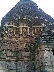
Jagannath Temple
Dharakote is famous for Lord Sri Jagannath temple. The Dharakote Temple looks similar to Puri Temple. Ekadasi Cart festival is famous among in this district as all well known about this. Around 40k-70k people visit this festival.
Dharakote Maharaja Palace
This is a 600-year-old palace of the King of Dharakote. The palace is situated just beside the Jagannath Temple.
Rani Sulakhyana Gitanjali Devi is the present Rani Saheb of Dharakote since 28 May 2010.
Sati Chita (Sati's Pyre)
It is said that Raja Jaganath Singh (1788/1830) on returning to his Palace after a hunt, saw a ray of light coming from inside a hut. The Raja entered the hut and saw a holy man meditating in front of a fire. The Holy man told the Raja that this was the place where Rani Chandama Devi had committed Sati. The Raja was impressed and immediately ordered the construction of a Math over that place, and later descendants of the Dharakote Royal family have kept the flame burning ever since, with the task of keeping the flame alive being entrusted to the Head Priests of the Math. The fire, known popularly as Sati Chita (Sati's Pyre) is tended to by a Mahant (Head Priest) at Sathi Math which is built on 9 acres of land at the entrance of Dharakote fort.
Geography
Dharakote is located at 19.38°N 84.34°E.[1] NH-59 (Gopalpur-on-Sea) passes through this town. It is located about 12 km north-west of the river Rushikulya, Aska, Ganjam. It is just 55 km from Silk City Brahmapur, Odisha.
Administratively it consisted of three subdivisions: Jahada with 85 villages, Kunanogada with 37 villages and Sahasrango with 66 villages.
Schools and colleges
- S.R.H.S. Sri Raja's High School
- Ananta Narayan Mahavidyalya
- Krushna Singh Girls High School
Villages of Dharakote
- Kanagiridi
- Panibandha
- Baharpur (12 km)
- Balarampur
- Baradabili (12 km)
- Arjuna palli
- Kahira palli
- Dharakote
- Dhaugam
- Golla Damodarpalli
- Jaga Mohan (2.4 km)
- Dasamaili
- Haripur
- Bethuar
- Dakabaja
- Jahada (4.4 km)
- Jhadabandha
- Jharapari
- Machhakot
- Manikapur (27 km)
- Mundamarai (3 km)
- Rugumu (8 km)
- Saradhapur(5.5 km)
- Singipur
- Pratapur (7 km)
Banks in Dharakote
- State Bank of India
- Utkal Gramya Bank
- ASKA Co-op Central Bank
Postal code of Dharakote: 761107
List of Rajas

- Raja SHOBHA CHANDRA SINGH 1168-
- Raja HADU SINGH 1476-1540
- Raja BAHADUR SINGH
- Raja NARAYAN SINGH 1602-1647
- Raja PURUSHOTTAM SINGH 1647-1699
- Raja RAM CHANDRA SINGH 1699-1731
- Raja JAI SINGH 1731-1748
- Raja RAJENDRA SINGH 1748-1780
- Raja DAMODAR SINGH 1780
- Raja KRUSHNA SINGH 1780-1788
- Raja JAGANATH SINGH 1788-1830
- Raja RAGHUNATH SINGH 1830-1863
- Raja BRAJA SUNDAR SINGH 1863-1880
- Raja MADAN MOHAN SINGH DEO 1880-1937
- Raja BRAJKISHORE SINGH DEO 1937-1938
- Raja KRUSHNA CHANDRA SINGH DEO 1938-1946
- Raja PADMANABH SINGH DEO 1946-1949
- GAPE BY
- Raja ANANT NARAYAN SINGH Deo 1974/2003
- Raja KISHORE CHANDRA SINGH Deo 2003/2010
- Rani Sulakhyana Geetanjali Devi - present ruler