Nuapada district
Nuapada is a district in Odisha state in India. Nuapada town is headquarter of the district. It has 1 Subdivision Nuapada, five blocks (1) khariar, (2) sinapali, (3) Boden, (4) Komna and (5) Nuapada. Nuapada District has 3 numbers of Notified Area Council, Khariar, Khariar Road, Nuapada and 6 Numbers of Tehsils.
Nuapada district | |
|---|---|
District | |
 | |
 Location in Odisha, India | |
| Coordinates: 20.65°N 82.833°E | |
| State | Odisha |
| Established | 27 March 1993 |
| Headquarters | Nuapada |
| Government | |
| • Collector & District Magistrate | Madhusmita sahoo, IAS |
| • Divisional Forest Officer Cum Wildlife Warden | Shri Khushwant Singh, IFS |
| • Superintendent of Police | Shri Vinit Agrawal, IPS |
| Area | |
| • Total | 3,408 km2 (1,316 sq mi) |
| Population (2011) | |
| • Total | 610,382 |
| • Density | 157/km2 (410/sq mi) |
| Languages | |
| • Official | Kosli, Odia, English |
| Time zone | UTC+5:30 (IST) |
| PIN | 766105 |
| Vehicle registration | OD-26 |
| Sex ratio | 1020 ♂/♀ |
| Literacy | 58.20% |
| Lok Sabha constituency | Kalahandi |
| Vidhan Sabha constituency | 2 |
| Climate | Aw (Köppen) |
| Precipitation | 1,230 millimetres (48 in) |
| Website | www |
| This article is part of a series on |
| Odisha |
|---|
 |
| Governance |
|
| Topics |
| GI Products |
|
|
Districts Divisions |
|
|
Major City, Town & Village of Nuapada District
- Khariar
- sinapali
- Khariar Road
- Bargaon, Odisha
- Nuapada
- Sagunbhadi
- Boden
- Brahmanpada
- Tukla
- Komna
- Bhella
- UDYANBANDH(KURESWAR)
History
The District of Nuapada was a part of Kalahandi District until early March 1993, but for administrative convenience, Kalahandi District was divided into two parts — Kalahandi and Nuapada vide State Government Notification No. DRC-44/93/14218/R dated 27 March 1993. Nuapada District now comprises one sub-division Nuapada, six tehsils (Nuapada, Komana, Khariar, Sinapalli, Boden and jonk) and five community development blocks (Khariar, Sinapalli, Boden, Nuapada and Komna).
Geography
Nuapada district is in the western part of Odisha, lying between latitude 20° 0' N and 21° 5' and between longitude 82° 20' E and 82° 40' E. Its boundaries extend in the north, west and south to Mahasamund district in Chhattisgarh and in the east to Bargarh, Balangir and Kalahandi districts. The district has an area of 3407.5 km² and the administrative headquarters is located at Nuapada.
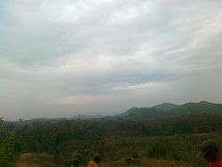
The plains of Nuapada subdivision are fringed by rugged hill ranges stretching southward, which belong to the main line of the Eastern Ghats and contain extensive plateaus of about 4000 ft (1200 m) in elevation.
Economy
Due to the conspicuous absence of any industry, the economy revolves around agricultural activities. Three major irrigation projects — the Upper Jonk, the Sunder dam, and the upcoming Lower Indira Irrigation Project — provide support to 45,000 acres of land. Rice is the main crop in the entire district. Other crops like corn (maize), cotton, and onion make up a major share of crops under cultivation. More than 10,000 households migrate to other states in search of better employment opportunities every year after the harvesting season is over. Though the district is tops in MGNREGS implementation, the advance provided by labor contractors before Nuakhai festival lure ignorant laborers into the plot. Due to unregistered and uninformed migration protection of migrant laborers has become a challenge to the government. In 2006 the Ministry of Panchayati Raj named Nuapada one of the country's 250 most backward districts (out of a total of 640).[1] It is one of the 19 districts in Odisha currently receiving funds from the Backward Regions Grant Fund Programme (BRGF).[1]
Demographics
According to the 2011 census Nuapada district has a population of 610,382 [2] roughly equal to the nation of Solomon Islands[3] or the US state of Wyoming.[4] This gives it a ranking of 524th in India (out of a total of 640).[2] The district has a population density of 157 inhabitants per square kilometre (410/sq mi) .[2] Its population growth rate over the decade 2001–2011 was 14.28%.[2] Nuapada has a sex ratio of 1020 females for every 1000 males,[2] and a literacy rate of 58.2%.[2]
At the time of the 2011 Census of India, 81.75% of the population in the district spoke Odia and 16.98% Chhattisgarhi as their first language.[5]
| Historical population | ||
|---|---|---|
| Year | Pop. | ±% p.a. |
| 1901 | 122,559 | — |
| 1911 | 147,489 | +1.87% |
| 1921 | 150,180 | +0.18% |
| 1931 | 178,787 | +1.76% |
| 1941 | 203,379 | +1.30% |
| 1951 | 219,850 | +0.78% |
| 1961 | 267,272 | +1.97% |
| 1971 | 338,894 | +2.40% |
| 1981 | 392,683 | +1.48% |
| 1991 | 469,482 | +1.80% |
| 2001 | 530,690 | +1.23% |
| 2011 | 610,382 | +1.41% |
| source:[6] | ||
Politics
Vidhan sabha constituencies
The following are the two Vidhan sabha constituencies[7][8] of Nuapada district and the elected members[9] of that area
| No. | Constituency | Reservation | Extent of the Assembly Constituency (Blocks) | Member of 14th Assembly | Party |
|---|---|---|---|---|---|
| 71 | Nuapada | None | Nuapada, Komna, Khariar Road (NAC) | Rajendra Dholkia | BJD |
| 72 | Khariar | None | Boden, Sinapalli, Khariar, Khariar (NAC) | Adhiraj Panigrahi | INC |
School & Colleges
- Khariar Autonomous College,Khariar
- Model Degree College,Khariar
- Delhi Public School Khariar Road-Nuapada
- Kendra vidyalaya Nuapada
- Navodaya Vidyalaya Tarbod
- Gyanjyoti kr Vidyalaya
- National High school
- Odisha Adarsha vidyalaya -Nuapada
- Western Odisha Residential Public School-khariar
- Kendriya Vidyalaya Khariar
- Raja A.T High School KhariarKhariar
- Model School ,Badi Khariar
- Odisha Adarsha vidyalaya -jhagrahi Komna
References
- Ministry of Panchayati Raj (8 September 2009). "A Note on the Backward Regions Grant Fund Programme" (PDF). National Institute of Rural Development. Archived from the original (PDF) on 5 April 2012. Retrieved 27 September 2011.
- "District Census 2011". Census2011.co.in. 2011. Retrieved 30 September 2011.
- US Directorate of Intelligence. "Country Comparison:Population". Retrieved 1 October 2011.
Solomon Islands 571,890 July 2011 est.
- "2010 Resident Population Data". U. S. Census Bureau. Retrieved 30 September 2011.
Wyoming 563,626
- 2011 Census of India, Population By Mother Tongue
- Decadal Variation In Population Since 1901
- Assembly Constituencies and their EXtent
- Seats of Odisha
- "List of Member in Fourteenth Assembly". ws.ori.nic.in. Archived from the original on 2 May 2007. Retrieved 19 February 2013.
MEMBER NAME
External links
| Wikimedia Commons has media related to Nuapada district. |
Places adjacent to Nuapada district | ||||||||||
|---|---|---|---|---|---|---|---|---|---|---|
| ||||||||||
Capital: Bhubaneswar | |||||||
| Governance |
|  | |||||
| Topics | |||||||
| GI products | |||||||
| Districts by division |
| ||||||
| Cities | |||||||