Sambalpur district
Sambalpur District is a district in the western part of state of Odisha, India. The historic city of Sambalpur is the district headquarters.
Sambalpur | |
|---|---|
District | |
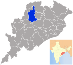 Location in Odisha, India | |
| Coordinates: 21.466°N 83.983°E | |
| Country | |
| State | Odisha |
| Headquarters | Sambalpur |
| Government | |
| • Collector & District Magistrate | Shri Shubham Saxena , IAS |
| • Divisional Forest Officer Cum Wildlife Warden | Dr Sanjeet Kumar, IFS |
| • Superintendent of Police | DR Kanwar Vishal Singh , IPS |
| Area | |
| • Total | 6,702 km2 (2,588 sq mi) |
| Population (2011) | |
| • Total | 1,041,099 |
| • Density | 122/km2 (320/sq mi) |
| Languages | |
| • Official | Odia, English |
| Time zone | UTC+5:30 (IST) |
| PIN | 768 xxx |
| Telephone code | 663 |
| Vehicle registration | OD-15, OR-15(till 2012) |
| Sex ratio | 1.031 ♂/♀ |
| Literacy | 67.25% |
| Lok Sabha constituency | Sambalpur |
| Vidhan Sabha constituency | 4
|
| Website | www |
| This article is part of a series on |
| Odisha |
|---|
 |
| Governance |
|
| Topics |
| GI Products |
|
|
Districts Divisions |
|
|
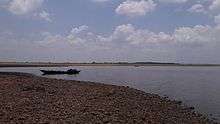
The district is located in the Mahanadi River basin. It has a total area of 6,702 km2 (2,588 sq mi), of which almost 60% of the district is covered in dense forest. The district is bounded by Deogarh District to the east, Bargarh and Jharsuguda districts to the west, Sundergarh District to the north, and Subarnapur and Angul districts in the south.
Sambalpur City is the connecting city between Chhattisgarh and Odisha. Whereas it used to be known for its importance as a diamond trading centre, nowadays it is mainly known for its textiles, especially the Sambalpuri Saree.
History
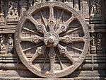
Sambalpur is mentioned in the book of Ptolemy (2nd century) as Sambalaka on the river Manada (the Mahanadi River). This gateway to the exotic charms of the western region of Odisha was the cradle of an ancient civilization and is an important landmark in India's cultural history.
Sambalpur State was a former princely state of British India. When its ruler died without a direct male heir in 1849, the British seized the state under the doctrine of lapse. It was attached to the British Bengal Presidency, but was transferred to the Central Provinces in 1862. The district was transferred back to Bengal in 1905, but the subdivisions of Phuljhar and Chandarpur-Padampur remained with the Central Provinces. Bengal's Odisha division became part of the new province of Bihar and Orissa in 1912, and in 1936 became the separate province of Odisha. After Indian Independence in 1947, Odisha became an Indian state.
Earlier Sambalpur District included four districts, i.e., modern day Sambalpur District, Bargarh District Jharsuguda District and Deogarh District which was subsequently divided into four separate districts. Bargarh was separated in 1993, and Jharsuguda and Deogarh districts were separated in 1994.
It is currently a part of the Red Corridor.[1]
Asta Sambhus
In the district of Sambalpur a large numbers of Shiva temples were built during the Chauhan period. The most important amongst them were the Asta Sambhus in the undivided Sambalpur district as detailed below:-
| Serial Number | Name | Place |
|---|---|---|
| 1 | Bimaleswar | Huma |
| 2 | Kedarnath | Ambabana (Now in Bargad District) |
| 3 | Biswanath | Degaa (Now in Bargad District) |
| 4 | Balunkeswar | Gaisama (Now in Bargad District) |
| 5 | Mandhata baba | Maneswar |
| 6 | Swapneswar | Sorna (Now in Bargad District) |
| 7 | Bisweswar | Soranda (Now in Bargad District) |
| 8 | Neelakntheswar | Niliee (Now in Bargad District) |
| 9 | Baba kamleswar | Sason, kamalchock |
Economy
The economy of Sambalpur District is basically dependent on agriculture and secondly on forests. Forests play an important role in the economy in terms of contribution to revenue, Domestic Product as well as dependence of people for livelihood. The people living adjacent to the reserved forests of Sambalpur Forest Division are heavily dependent on these forests. In the past Sambalpur has been a great centre of diamond trade. Kendu leaf (Diospyros Melanoxylon) is also produced in Sambalpur. Kendu leaf is one of the most important non-wood forest products of Sambalpur and is also called as green gold of Odisha. Lately industrialisation has started in the district and the prime industries of power, alumina and steel have been established. The place is famous for its globally renowned textile bounded patterns and fabrics locally known as Baandha. Sambalpur is famous for its Hand loom textile works. Popularly known as Sambalpuri Textile. It has earned international fame for its unique pattern, design and texture. Apart from textiles, Samabalpur has a rich tribal heritage and fabulous forestlands.
In 2006 the Ministry of Panchayati Raj named Sambalpur one of the country's 250 most backward districts (out of a total of 640).[2] It is one of the 19 districts in Odisha currently receiving funds from the Backward Regions Grant Fund Programme (BRGF).[2]
Demographics


According to the 2011 census Sambalpur district has a population of 1,041,099,[3] roughly equal to the nation of Cyprus[4] or the US state of Rhode Island.[5] This gives it a ranking of 433rd in India (out of a total of 640). The district has a population density of 158 inhabitants per square kilometre (410/sq mi). Its population growth rate over the decade 2001–2011 was 11.63%. Sambalpur has a sex ratio of 973 females for every 1000 males, and a literacy rate of 76.91%.[3]
| Historical population | ||
|---|---|---|
| Year | Pop. | ±% p.a. |
| 1901 | 215,645 | — |
| 1911 | 249,710 | +1.48% |
| 1921 | 261,043 | +0.44% |
| 1931 | 291,723 | +1.12% |
| 1941 | 328,576 | +1.20% |
| 1951 | 355,685 | +0.80% |
| 1961 | 445,745 | +2.28% |
| 1971 | 549,157 | +2.11% |
| 1981 | 682,700 | +2.20% |
| 1991 | 809,017 | +1.71% |
| 2001 | 930,476 | +1.41% |
| 2011 | 1,041,099 | +1.13% |
| source:[6] | ||
Languages
At the time of the 2011 Census of India, 78.80% of the population in the district spoke Odia, 6.85% Hindi, 4.98% Kisan, 3.42% Munda, 1.49% Kharia, 0.78% Kurukh, 0.66% Urdu, 0.57% Bengali, 0.45% Telugu and 0.44% Mundari as their first language.[7]
Languages spoken here include Asuri, an Austroasiatic language spoken by approximately 17,000. Oraon and kisan tribes usually speak Kurukh and Sadri. Munda tribe speak their own Ho language. Kharia use their own Kharia language.;[8] and Bhunjia, spoken by approximately 7000 Bhunjia Adivasis.[9] Languages spoken in Sambalpur, Burla and Hirakud is Sambalpuri Odia. Other communities speak Hindi and in their own language. 90% of the population speaks Sambalpuri Odia. Sadri language is also popular among people of this district.
Culture
Tourism
Samaleswari, the presiding deity of this region is enshrined at 'Samlei Gudi' on the bank of Mahanadi River. The other temple of importance is the Budharaja Temple, dedicated to Shiva and is perched atop the Budharaja hill. These temples are located at a few kilometres' distance from Sambalpur. The Hirakud Dam, the longest dam of the world, is some 15 kilometres from Sambalpur.
Education
Politics
Vidhan sabha constituencies
The following is the 4 Vidhan sabha constituencies[10][11] of Sambalpur district and the elected members[12] of that area
| No. | Constituency | Reservation | Extent of the Assembly Constituency (Blocks) | Member of 14th Assembly | Party |
|---|---|---|---|---|---|
| 15 | Kuchinda | ST | Kuchinda (NAC), Kuchinda, Bamra, Jamankira | Rabi Narayan Nayak | BJP |
| 16 | Rengali | SC | Rengali, Dhankauda, Maneswar (part) | Ramesh Patua | BJD |
| 17 | Sambalpur | None | Sambalpur (M), Burla (NAC), Hirakud (NAC) | Jay Narayan Mishra | BJP |
| 18 | Rairakhol | None | Rairakhol (NAC), Rairakhol, Jujomura, Naktideul, Maneswar (part) | Er. Rohit Pujari | BJD |
References
- "83 districts under the Security Related Expenditure Scheme". IntelliBriefs. 2009-12-11. Retrieved 2011-09-17.
- Ministry of Panchayati Raj (September 8, 2009). "A Note on the Backward Regions Grant Fund Programme" (PDF). National Institute of Rural Development. Archived from the original (PDF) on April 5, 2012. Retrieved September 27, 2011.
- "District Census 2011". Census2011.co.in. 2011. Retrieved 2011-09-30.
- US Directorate of Intelligence. "Country Comparison:Population". Retrieved 2011-10-01.
Cyprus 1,120,489 July 2011 est.
- "2010 Resident Population Data". U. S. Census Bureau. Retrieved 2011-09-30.
Rhode Island 1,052,567
- Decadal Variation In Population Since 1901
- 2011 Census of India, Population By Mother Tongue
- M. Paul Lewis, ed. (2009). "Asuri: A language of India". Ethnologue: Languages of the World (16th ed.). Dallas, Texas: SIL International. Retrieved 2011-09-28.
- M. Paul Lewis, ed. (2009). "Bhunjia: A language of India". Ethnologue: Languages of the World (16th ed.). Dallas, Texas: SIL International. Retrieved 2011-09-30.
- Assembly Constituencies and their EXtent
- Seats of Odisha
- "List of Member in Fourteenth Assembly". ws.ori.nic.in. Archived from the original on 2 May 2007. Retrieved 19 February 2013.
Member Name
External links
| Wikimedia Commons has media related to Sambalpur district. |
Places adjacent to Sambalpur district | ||||||||||
|---|---|---|---|---|---|---|---|---|---|---|
| ||||||||||
Capital: Bhubaneswar | |||||||
| Governance |
|  | |||||
| Topics | |||||||
| GI products | |||||||
| Districts by division |
| ||||||
| Cities | |||||||