Cerise (satellite)
Cerise (French for "cherry") was a French military reconnaissance satellite. Its main purpose was to intercept HF radio signals for French intelligence services.[1] With a mass of 50 kg, it was launched by an Ariane rocket from Kourou in French Guiana at 17:23 UT, 7 July 1995.[1] Cerise's initial orbital parameters were period 98.1 min, apogee 675 km, perigee 666 km, and inclination 98.0 deg.[1]
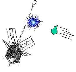 Illustration of debris colliding with Cerise | |
| Mission type | Military reconnaissance |
|---|---|
| COSPAR ID | 1995-033B |
| SATCAT no. | 23606 |
| Spacecraft properties | |
| Bus | SSTL-70 |
| Manufacturer | Alcatel Space · Surrey Satellite Technology |
| Launch mass | 50 kg (110 lb) |
| Dimensions | 0.6 × 0.3 × 0.3 m (1.97 × 0.98 × 0.98 ft) |
| Start of mission | |
| Launch date | 7 July 1995, 16:23:34 UTC |
| Rocket | Ariane 4 V-75 |
| Launch site | Guiana Space Centre ELA-2 |
| Contractor | Arianespace |
| Orbital parameters | |
| Reference system | Geocentric |
| Regime | Sun-synchronous |
| Eccentricity | 0.0005756 |
| Perigee altitude | 581 km (361 mi) |
| Apogee altitude | 589 km (366 mi) |
| Inclination | 98.2413° |
| Mean motion | 14.94 rev/day |
| Epoch | 27 December 2016 12:15:03 UTC |
It was hit by a catalogued space debris object from an Ariane rocket in 1996, making it the first verified case of an accidental collision between two artificial objects in space.[2]
The collision tore off a 2.8-2.9 metre (9.2-9.5 foot) portion of Cerise's gravity-gradient stabilization boom, which left the satellite severely damaged.[3]
See also
References
- "SPACEWARN Bulletin Number 501". NASA. Retrieved 26 August 2009.
- "CO2 prolongs life of space junk". BBC News. 5 May 2005. Retrieved 8 March 2006.
- "History of On-Orbit Satellite Fragmentations" (PDF). NASA Orbital Debris Program Office. June 2008. pp. 368–369. Retrieved 7 December 2013.
External links
Earth reconnaissance satellites (excluding Russia and the United States) | |||||||
|---|---|---|---|---|---|---|---|
| Canada |
| ||||||
| China |
| ||||||
| France |
| ||||||
| Germany |
| ||||||
| India |
| ||||||
| Israel |
| ||||||
| Italy |
| ||||||
| Japan |
| ||||||
| South Korea |
| ||||||
| Spain |
| ||||||
| Turkey |
| ||||||
| United Kingdom |
| ||||||
This article is issued from Wikipedia. The text is licensed under Creative Commons - Attribution - Sharealike. Additional terms may apply for the media files.