SAR-Lupe
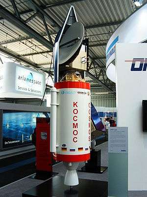
SAR-Lupe is Germany's first reconnaissance satellite system and is used for military purposes. SAR is an abbreviation for synthetic aperture radar and "Lupe" is German for magnifying glass. The SAR-Lupe program consists of five identical (770 kg) satellites, developed by the German aeronautics company OHB-System which are controlled by a ground station[1] which is responsible for controlling the system and analysing the retrieved data. A large data archive of images will be kept in a former Cold War bunker belonging to the Kommando Strategische Aufklärung (Strategic Reconnaissance Command) of the Bundeswehr. The total price of the satellites was over 250 million Euro.[2]
Specifications
SAR-Lupe's "high-resolution" images can be acquired day or night through all weather conditions. The satellites are able to provide up-to-date imagery from almost all regions of the world.[2]
The first satellite was launched from Plesetsk in Russia on 19 December 2006, about a year after the intended launch date; four more satellites were launched at roughly six-month intervals, and the entire system achieved full operational readiness on 22 July 2008.[3] The constellation is planned for 10 years of operational life.[2]
The five satellites operate in three 500-kilometre orbits in planes roughly sixty degrees apart. They use an X-band radar with a three-metre dish, providing a resolution of about 50 centimetres over a frame size of 5.5 km on a side ('spotlight mode', in which the satellite rotates to keep the dish pointed at a single target) or about one metre over a frame size of 8 km x 60 km ('stripmap mode', in which the satellite maintains a fixed orientation over the earth and the radar image is formed simply by the satellite's motion along its orbit). Response time for imaging of a given area is ten hours or less. Thales Alenia Space provided the core of the Synthetic Aperture Radar sensors.[4]
History
The SAR-Lupe satellites are the first German military satellites.[2]
The testing of SAR-Lupe involved an inverse procedure, in which the satellite, mounted in a radome on Earth, was used to image the International Space Station, whose orbit is reasonably close to the one the satellite will eventually be in. One-metre resolution at the ISS was apparently achieved.
On 30 July 2002 a cooperation treaty between Germany and France was signed, under which the SAR-Lupe satellites and the French Helios optical reconnaissance satellite will operate jointly. Other EU countries have been invited to join as well and Italy has shown considerable interest.
Radar component
XSAR of SAR-Lupe is observing in X-band (center frequency of 9.65 GHz corresponding to a wavelength of 3.1 cm).
- Global observation coverage capability
- Use of a parabolic SAR reflector antenna of size: 3.3 m x 2.7 m. The choice of using a single beam offset reflector antenna instead of an active beam-steering antenna represented a major cost saving in the development of the instrument. SAR-Lupe uses a single beam offset reflector antenna and a TWT (Travelling Wave Tube) based transmitter, illuminated by a feed horn on a deployable boom. The highly efficient TWT and a low-loss high-gain antenna are providing good power potential for radar with efficient DC power utilization. 15) 16)
Prior to an image acquisition, the satellite rolls in an appropriate position and stabilizes its attitude. Then, the SAR image is acquired. After that, the satellite rolls back into its standby attitude and continues to load its batteries preparing itself for the next SAR image acquisition.
- Number of scenes of area of interest: ≥ 30/day
- System response time: < 36 hours
- System availability: 95%
- Automated monitoring and control of the constellation via a ground control station
- Automated data reception and image processing
- LEOP (Launch and Early Orbit Phase) support is provided by DLR/GSOC
- The mean response time of the system is in the range of 10 hours. System availability is provided by the distribution of the satellites in their orbital planes.
- The modular interface design of the ground segment permits also future integration into an international reconnaissance network (mutual utilization of the system, etc.).
- SAR imaging modes provided: stripmap and spotlight. Stripmap imaging involves antenna pointing into a fixed direction (normally in cross-track). Internally, these modes are referred to as “Strip-SAR” and “Slip-SAR.” Strip-SAR observations are conducted in the nadir direction. In Slip-SAR mode, the entire spacecraft is rotated into the direction of the target to increase the integration time and therefore the in-track resolution.
- Spatial resolution of SAR data: 0.5 m in spotlight mode for a scene of about 5.5 km x 5.5 km in size; a stripmap scene has a size of 60 km x 8 km. It can provide NESZ(Noise Equivalent Sigma Naught) range up to -19.91 dB.
- Satellite operations permit “spotlight imaging” of a scene. This involves rotation of the entire S/C about a target area to increase the integration time of the scene (the SAR beacon is pointable). In SAR-Lupe terminology, spotlight imaging is referred to as “Slip-SAR.”
- An onboard image storage capability of 128 Gbit (EOL) is provided.
- The main image products are: 1) stripmap scenes of size 60 km x 8 km, and 2) square scenes of 5.5 km x 5.5 km in size.
- The following additional products can also be generated: a) elevation models from multipass interferometric products, b) multipass stereo products, c) change detection products, d) products with enhanced radiometric resolution.
Launches
| Satellite | COSPAR | Date | Carrier rocket | Launch site | Launch status |
|---|---|---|---|---|---|
| SAR-Lupe-1 | 2006-060A | 19 December 2006 | Cosmos-3M | Plesetsk | Success |
| SAR-Lupe-2 | 2007-030A | 2 July 2007 | Cosmos-3M | Plesetsk | Success |
| SAR-Lupe-3 | 2007-053A | 1 November 2007 | Cosmos-3M | Plesetsk | Success |
| SAR-Lupe-4 | 2008-014A | 27 March 2008 | Cosmos-3M | Plesetsk | Success |
| SAR-Lupe-5 | 2008-036A | 22 July 2008 | Cosmos-3M | Plesetsk | Success |
Contractors
- Prime contractor: OHB-System[5]
- LSE Space Engineering & Operations AG[6]
Future
A replacement of SAR-LUPE, called SARah, will be put into service from 2017-2019. It will consist of 3 radar satellites and one optical satellite. The satellites of SARah will be bigger and more capable than those of SAR-Lupe.[7] SARah-1, a phased-array-antenna satellite, and SARah-2 and 3, passive-antenna synthetic aperture radars, are planned to be launched on Falcon 9 sometime in 2019 and 2020.[8]
See also
- SAOCOM, two Argentine SAR-satellites.
- COSMO-SkyMed, a system of four military and civil SAR-satellites of Italy
- TerraSAR-X, a civilian German radar satellite
- European Union Satellite Centre
References
- SAR-Lupe ground station: Zentrum für Nachrichtenwesen der Bundeswehr (ZNBw), Max-Planck-Str. 17, 53501 Gelsdorf 50.5683°N 7.0363°E
- https://space.skyrocket.de/doc_sdat/sar-lupe.htm
- Stephen Clark (July 22, 2008). "Radar reconnaissance spacecraft launched". Spaceflight Now. Retrieved May 6, 2014.
- "Successful Launch Of Sar-lupe Satellite, With Thales Alenia Space's SAR Sensor Electronics Units" (Press release). July 3, 2007. Archived from the original on May 6, 2014. Retrieved May 6, 2014.
- OHB-System AG (SAR-Lupe)
- LSE Space Engineering & Operations AG Archived 2006-10-24 at the Wayback Machine
- http://www.spiegel.de/wissenschaft/technik/sarah-bundeswehr-will-drei-neue-spionagesatelliten-kaufen-a-907583.html
- http://www.spacex.com/press/2013/08/08/spacex-awarded-launch-german-radar-reconnaissance-satellite-system
Earth reconnaissance satellites (excluding Russia and the United States) | |||||||
|---|---|---|---|---|---|---|---|
| Canada |
| ||||||
| China |
| ||||||
| France |
| ||||||
| Germany |
| ||||||
| India |
| ||||||
| Israel |
| ||||||
| Italy |
| ||||||
| Japan |
| ||||||
| South Korea |
| ||||||
| Spain |
| ||||||
| Turkey |
| ||||||
| United Kingdom |
| ||||||