Kapiti Coast District
Kapiti Coast District is a local government district in the lower North Island of New Zealand, 50 km north of Wellington.
Kapiti Coast District | |
|---|---|
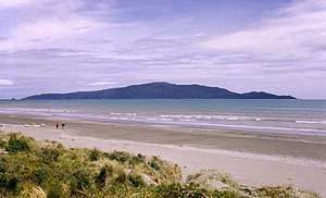 Looking across Waikanae Beach to Kapiti Island | |
 | |
| Country | New Zealand |
| Region | Wellington |
| District | Kāpiti Coast District Council |
| Wards | Ōtaki Waikanae Paraparaumu Paekākāriki-Raumati |
| Seat | Paraparaumu |
| Government | |
| • Mayor | K (Guru) Gurunathan [1] |
| • Deputy Mayor | Janet Holborow[2] |
| Area | |
| • Total | 731.25 km2 (282.34 sq mi) |
| Population (June 2019)[3] | |
| • Total | 56,000 |
| • Density | 77/km2 (200/sq mi) |
| Time zone | UTC+12 (NZST) |
| • Summer (DST) | UTC+13 (NZDT) |
| Postcode(s) | 5032, 5034, 5036, 5381, 5391, 5512, 5573, 5581, 5582, 5583 [4] |
| Website | Kāpiti Coast District Council |
The district is named after Kapiti Island, a prominent landmark 5 km offshore. The population of the district is concentrated in the chain of coastal settlements along State Highway One: Ōtaki, Te Horo, Waikanae, Paraparaumu, Raumati Beach, Raumati South, and Paekākāriki. Paraparaumu is the most populous of these towns and the commercial and administrative centre. Much of the rural land is given over to horticulture; market gardens are common along the highway between the settlements. Paraparumu has a small airport with daily scheduled flights to across the Cook Strait to Nelson and Blenheim.
The area available for agriculture and settlement is narrow and coastal. Much of the eastern part of the district is within the Tararua Forest Park, which covers the rugged Tararua Range, with peaks rising to over 1500 m.
Administration
The district is administered by the Kāpiti Coast District Council,[5] a territorial authority elected by residents every three years. The council consists of a mayor and 10 councillors.[6]
Although "Kapiti Coast District" is the official name of the district,[7] the council uses the Maori-language spelling "Kāpiti" for its name.
Greater Wellington is responsible for regional governance of the district including public transport, water and environmental management. Residents also elect one of four community boards for their local area. Community boards are primarily advocates for their local area and administering community grant funding.[8]
Features
Apart from Kapiti Island, perhaps the most visible features of the Kapiti Coast are Kapiti Coast Airport and Queen Elizabeth Park. The airport is sandwiched between Paraparaumu (to the north) and Raumati (to the south). Possessing three runways (one of which is now closed), it once served as the main airport of the Wellington region, but was until recently used mainly by aeroclubs. In 2011 scheduled commercial flights from Kapiti to Auckland were resumed. The park, lying to the south of Raumati, is a popular attraction which covers some 12 km². The park extends to Paekākāriki, and includes the Wellington Tramway Museum.
Other tourist attractions on the Kapiti Coast include the Paraparaumu Golf Course. Another attraction a few kilometres north of the town centre is the Southward Car Museum in Otaihanga.
The district is on the North Island Main Trunk railway line (NIMT), and is served as far north as Waikanae by suburban passenger trains operating on what is referred to as the Kapiti Line.
Population
The district's population in June 2019 was 56,000.[3] Although administratively part of the Wellington Region, the Kapiti Coast is geographically and socially distinct from Wellington, Porirua and the Hutt Valley, which together make up the nucleus of the region. However many residents travel into Wellington each day for work and the whole Kapiti Coast is a popular weekend destination for the people of the Wellington Region. Many migrate to the area for their retirement. The town of Paraparaumu, considered the pivot of the district, is located about 55 km north of Wellington.
Demographics
| Historical population | ||
|---|---|---|
| Year | Pop. | ±% p.a. |
| 2006 | 46,197 | — |
| 2013 | 49,104 | +0.88% |
| 2018 | 53,673 | +1.80% |
| Source: [9] | ||
Kapiti Coast District had a population of 53,673 at the 2018 New Zealand census, an increase of 4,569 people (9.3%) since the 2013 census, and an increase of 7,476 people (16.2%) since the 2006 census. There were 21,753 households. There were 25,314 males and 28,359 females, giving a sex ratio of 0.89 males per female. Of the total population, 9,285 people (17.3%) were aged up to 15 years, 7,386 (13.8%) were 15 to 29, 22,935 (42.7%) were 30 to 64, and 14,067 (26.2%) were 65 or older. Figures may not add up to the total due to rounding.
Ethnicities were 87.7% European/Pākehā, 14.7% Māori, 3.0% Pacific peoples, 4.6% Asian, and 2.2% other ethnicities. People may identify with more than one ethnicity.
The percentage of people born overseas was 22.6, compared with 27.1% nationally.
Although some people objected to giving their religion, 52.9% had no religion, 35.8% were Christian, and 3.9% had other religions.
Of those at least 15 years old, 10,188 (23.0%) people had a bachelor or higher degree, and 7,167 (16.1%) people had no formal qualifications. The median income was $29,700. The employment status of those at least 15 was that 18,792 (42.3%) people were employed full-time, 6,435 (14.5%) were part-time, and 1,596 (3.6%) were unemployed.[9]
Populated places
Kapiti Coast District consists of the following towns, localities, settlements and communities:
|
|
|
|
Relationship with Wellington
Many Kapiti Coast District residents work in Wellington. Commuters to the four cities located in the Greater Wellington Region make up 36% of the workforce of the Kapiti Urban Area (Paraparaumu, Waikanae, Paekākāriki) and 12% of the workforce of Ōtaki.[10] One of Wellington's two main commuter rail links, the Kapiti Line, terminates in Waikanae. There are also commuter bus services.
State Highway One connects the Kapiti Coast to Wellington. The road is a narrow, coastal highway that is highly congested and has been subject to occasional closure due to land slides. The Transmission Gully Motorway has long been mooted both as a commuter route and an alternative access to the capital in case of a civil defence emergency. Construction of the route officially began on 8 September 2014 and completion is scheduled for 2020.
The population of the district has grown rapidly since the 1980s, fueled in large part by Wellingtonians moving to the coast to retire. More Kapiti Coasters are over the retirement age than in any other district or city in the country – 23.3% of the district's population is over 65; compared with 9.4% in the four cities of the Wellington Region, and 12.1% of New Zealand as a whole.[10]
History
Most of the district was originally part of the now-defunct Hutt County. The Kapiti Borough Council was carved from it in 1973; in the local government reorganization of 1989, the Borough Council was replaced by the Kāpiti Coast District Council, and the area under its jurisdiction expanded northwards to include Waikanae and Ōtaki, which had been part of the former Horowhenua County.
References
- "Mayor". www.kapiticoast.govt.nz. Kāpiti Coast District Council. Retrieved 2020-04-18.
- "Councillors". www.kapiticoast.govt.nz. Kāpiti Coast District Council. Retrieved 2020-04-26.
- "Subnational Population Estimates: At 30 June 2019". Statistics New Zealand. 22 October 2019. Retrieved 11 January 2020.
- "Kapiti Coast District Postcodes (PDF)" (PDF). New Zealand Post. Retrieved 2020-04-18.
- "Kāpiti Coast District Council". kapiticoast.govt.nz. 2016-04-08. Retrieved 2016-04-08.
- "Our Elected Members". www.kapiticoast.govt.nz. Kāpiti Coast District Council. Retrieved 2020-04-18.
- "NZGB Gazetteer". New Zealand Gazetter. Retrieved 2020-04-18.
- "Community Boards". Kāpiti Coast District Council. Retrieved 2020-04-18.
A Board’s role is mainly advocacy but it also has powers to make some decisions about issues within its boundaries. Boards make submissions to Council and other statutory agencies. They control local funds for making grants to individuals and groups for community purposes.
- "Statistical area 1 dataset for 2018 Census". Statistics New Zealand. March 2020. Kapiti Coast District (043). 2018 Census place summary: Kapiti Coast District
- "Commuting Patterns in New Zealand: 1996–2006 – Statistics New Zealand". Stats.govt.nz. 2009-07-22. Retrieved 2012-12-27.