Pukekohe
Pukekohe is a town in the Auckland Region of the North Island of New Zealand. Located at the southern edge of the Auckland Region, it is in South Auckland, between the southern shore of the Manukau Harbour and the mouth of the Waikato River. The hills of Pukekohe and nearby Bombay Hills form the natural southern limit of the Auckland region. Pukekohe is located within the political boundaries of the Auckland Council, following the abolition of the Franklin District Council on 1 November 2010.
Pukekohe | |
|---|---|
 Pukekohe | |
| Coordinates: 37°12′S 174°54′E | |
| Country | New Zealand |
| Region | Auckland |
| Territorial authority | Auckland Council |
| Local board | Franklin |
| Area | |
| • Urban | 87.09 km2 (33.63 sq mi) |
| Population (June 2019)[1] | |
| • Urban | 24,300 |
| • Urban density | 280/km2 (720/sq mi) |
| Postcode | 2120 |
| Area code(s) | 09 |
With a population of 24,300 (June 2019),[1] Pukekohe is the 24th largest urban area in New Zealand, and the third largest in the Auckland Region behind Auckland itself and Hibiscus Coast.
Pukekohe is a rural service town for the area formerly known as the Franklin District. It has a population of 24,300 (June 2019),[1] mainly of European descent, with significant Māori and ethnic Indian and East Asian communities. There are also a notable number of people of South African and Dutch descent. The population growth from 2007 to 2008 was 2.2 percent. The fertile volcanic soil and warm moist climate supports a large horticultural and dairy farming industry; the Pukekohe long keeper onion is well known internationally.
History and culture
Māori history
The Māori word puke-kohe means "hill of the kohekohe", New Zealand's native mahogany.
During the period of the Musket Wars of 1807-1843, Northern iwi (tribes) attacked parts of the Auckland area, including Pukekohe. From the 1820s, as a result of these attacks, the resident Māori population who survived mainly migrated south.
European settlement
When European settlers arrived, the remnant Māori population initially provided them with food supplies. As the number of settlers grew, the Pukekohe area, which was largely bush covered, was opened up after 1843 and individual farmers purchased small blocks of land which they cleared by hand.
By 1863, the land was still bush covered but with an increasing number of small isolated farms. When Kīngitanga Māori refused to swear an oath of allegiance to the Crown, many Māori moved out of the area, but some remained. A Māori from this area guided the first gunboats through the Waikato Heads and through the shoals of the Waikato River delta to help put down the rebel Kīngitanga uprising.
New Zealand Wars
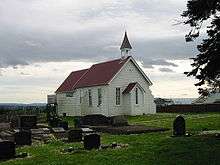
A major battle of the 1863 Land Wars was fought at Pukekohe East between 11 armed settlers, who were converting the Pukekohe East church into a redoubt and approximately 200–300 Māori rebels, mainly from the Waikato area. Although surprised and severely outnumbered, the settlers held off the Kīngitanga invaders until troops arrived. No settlers were killed or injured while 30 Māori were killed with an unknown number wounded. 6 bodies were found near the church and 24 were later found buried in the bush. The church still exists today and the bullet holes are still visible.
Although there were many other attacks on settlers in Auckland the Māori preferred isolated targets. As most women and children had been evacuated to Auckland city most of those murdered were men and teenage boys. Rebels were able to hide in the pockets of bush and live off the settlers goods and livestock. Nearly the entire Pukekohe area was abandoned to the rebels apart from Military outposts. Isolated attacks occurred as late as November 1863 after the Battle of Rangiriri.[2]
Marae
Ngā Hau e Whā Marae is located in the Pukekohe area.[3] It is the tribal meeting grounds of Ngāti Tamaoho and the Waikato Tainui hapū of Ngāi Tai and Ngāti Tamaoho.[4]
Local government
Pukekohe had a local government just like other suburbs of Auckland at that time. The local government was called Pukekohe Borough Council, which started in 1912 and merged into Franklin District Council in 1989, eventually being amalgamated into Auckland Council in November 2010.
The mayors of Pukekohe Borough Council were:
- 1912–1912 William Dunn
- 1912–1915 C. K. Lawrie
- 1915–1919 Henry Greathead Rex Mason
- 1919–1921 C. K. Lawrie
- 1921–1935 John Routly
- 1935–1938 C. K. Lawrie
- 1938–1941 John Routly
- 1941–1950 Maxwell Rae Grierson
- 1950–1963 S. C. Childs
- 1963–1974 C. W. J. Lawrie
- 1974–1989 Max R. Short
Education
There are many schools in the Pukekohe area, including Pukekohe High School, Pukekohe Intermediate School, Valley School, Hill School, Pukekohe Christian School, Pukekohe North School and Kingsgate Primary Christian School
Pukekohe High School is known for its strong science department and regularly places highly in the Auckland City Secondary Schools Science Fair. Wesley College originally founded in 1844 and New Zealand’s oldest boarding secondary school is situated in Paerata just minutes from Pukekohe and famous for producing many All Blacks despite its roll size of only 350 approximately.
Sports
Pukekohe Park Raceway is a motorsports and horse-racing facility. Opened in 1963, this circuit is famous for having hosted the New Zealand Grand Prix 29 times between 1963 and 2000, as well as the V8 International (a round of the V8 Supercars championship) between 2001 and 2007. The V8 Supercars event was moved to Hamilton for five years, but returned to Pukekohe in 2013.[5]
ECOLight Stadium is home of the Counties-Manukau Steelers.
Pukekohe is home to Pukekohe AFC who compete in the Auckland Football Federation/Northern Football Federation Conference League, and Pukekohe High School football teams.
Media
Franklin County News is the local newspaper distributed twice weekly to homes in Pukekohe and surrounding towns, including Waiuku and Tuakau.[6]
The Post Newspaper issues almost 22,000 copies weekly on a Tuesday within Franklin and Tuakau and is based in Waiuku.
In 2015, the online events calendar and photo news Franklin Life NZ was launched.
In 2013, the film Mt. Zion was released in New Zealand, portraying Māori life in 1970s Pukekohe.
Transport
Pukekohe railway station is on the North Island Main Trunk Railway and is the southernmost station of the Auckland rail network, at the end of the Southern Line. The portion of the line between Papakura and Pukekohe is not electrified, so diesel shuttles connect Pukekohe with electric trains at Papakura. In July 2017, it was announced that the purchase of battery-powered electric trains had been "agreed in principle"[7] by Auckland Council and that an all-electric service would be operational in 2019 (provisionally, subject to conditions), four years after completion of the rest of the region's electrified rail network. However, the purchase of batter-powered trains did not proceed. In 2020, the government announced funding to extend electrification from Papakura to Pukekohe.[8]
There are several loop bus services serving central Pukekohe and also connecting to the western and southern townships of Patumahoe, Waiuku, Tuakau and Port Waikato. There are no bus services north of the town (beyond Paerata) and none at all serving travel to the east.
Notable people
- Bill Birch, MP—was a long-time resident
- Peter (Possum) Bourne, Rallycar driver
- Leslie Comrie, astronomer and pioneer in mechanical computation
- Andy Dalton, resident and All Blacks captain
- Simon Doull, cricket representative and radio personality
- A. J. Hackett, entrepeneur who popularised bungee jumping
- Madonna Harris, resident and sportswoman
- Jonah Lomu, All Black, born in Pukekohe, educated at Wesley College
- Rex Mason, mayor and MP
- Mick Peck, award-winning magician and entertainer
- Malietoa Tanumafili II, Samoan Head of State—educated at Wesley College
- Allan Wilson, molecular biologist—grew up in the area
- Peter Fa'afiu, diplomat, global director of Amnesty International[9]
See also
Neighbouring areas | ||||||||||
|---|---|---|---|---|---|---|---|---|---|---|
| ||||||||||
References
- "Subnational Population Estimates: At 30 June 2019". Statistics New Zealand. 22 October 2019. Retrieved 11 January 2020.
- The Journal of William Morgan.p78,80,83,85,89.N Morris Editor. Auckland City Council.1963.
- "Māori Maps". maorimaps.com. Te Potiki National Trust.
- "Te Kāhui Māngai directory". tkm.govt.nz. Te Puni Kōkiri.
- Pukekohe, nzherald.co.nz; accessed 30 March 2015.
- Franklin County News
- "Auckland Council agrees to buy 17 battery-powered and electric trains for Pukekohe line". The New Zealand Herald. 26 July 2017. Retrieved 29 January 2020.
- Jane Paterson (29 January 2020). "Govt's $12b infrastructure spend: Rail, roads and DHBs the big winners". Retrieved 29 January 2020.
- https://www.stuff.co.nz/auckland/115012706/pukekohe-man-first-pacific-islander-take-top-spot-at-amnesty-international
External links
- Pukekohe - the heart of Franklin
- Franklin district
- Pukekohe Park Raceway
- Photographs of Pukekohe held in the Auckland Libraries heritage collections.