Ruapehu District
Ruapehu District is a territorial authority in the centre of New Zealand's North Island.
Ruapehu District | |
|---|---|
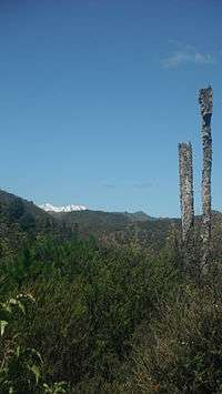 Mount Ruapehu in the Ruapehu District along Ruatiti Road | |
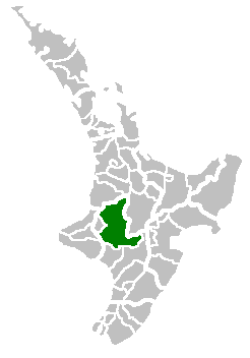 Location of the Ruapehu District | |
| Country | New Zealand |
| Island | North Island |
| Region | Manawatū-Whanganui |
| Named for | Mount Ruapehu |
| Seat | Taumarunui |
| Towns | |
| Government | |
| • Mayor | Don Cameron |
| • Deputy Mayor | Karen Ngatai |
| • Chief Executive | Clive Manley |
| Area | |
| • Total | 6,370 km2 (2,460 sq mi) |
| Highest elevation | 2,797 m (9,177 ft) |
| Population (June 2019)[1] | |
| • Total | 12,750 |
| • Density | 2.0/km2 (5.2/sq mi) |
| Time zone | UTC+12 (NZST) |
| • Summer (DST) | UTC+13 (NZDT) |
| Area code(s) | 07 (northern and central) 06 (southern) |
| Website | Ruapehu District Council |
It has an area of 6,730 square kilometers and the district's population in June 2019 was 12,750.[1]
Features
The district is landlocked, and contains the western half of the Tongariro National Park, including Mount Ruapehu and the western sides of Mount Ngauruhoe and Mount Tongariro, as well as part of the Whanganui National Park. The district is also home to the world-famous Raurimu Spiral on the North Island Main Trunk railway line.
The tourist towns of Raetihi, Whakapapa Village, National Park and Ohakune are located near Mount Ruapehu in the south east of the district. Waiouru, with an elevation of 815 metres, is in the extreme south east of the district and houses the large Waiouru Army Camp. The southern section of the infamous Desert Road section of State Highway 1 runs through the east of the district, from Waiouru to Rangipo.
Demographics
| Historical population | ||
|---|---|---|
| Year | Pop. | ±% p.a. |
| 2006 | 13,572 | — |
| 2013 | 11,844 | −1.93% |
| 2018 | 12,309 | +0.77% |
| Source: [2] | ||
Ruapehu District had a population of 12,309 at the 2018 New Zealand census, an increase of 465 people (3.9%) since the 2013 census, and a decrease of 1,263 people (-9.3%) since the 2006 census. There were 4,617 households. There were 6,288 males and 6,021 females, giving a sex ratio of 1.04 males per female. Of the total population, 2,715 people (22.1%) were aged up to 15 years, 2,208 (17.9%) were 15 to 29, 5,454 (44.3%) were 30 to 64, and 1,932 (15.7%) were 65 or older. Figures may not add up to the total due to rounding.
Ethnicities were 68.8% European/Pākehā, 43.4% Māori, 2.8% Pacific peoples, 3.4% Asian, and 1.7% other ethnicities. People may identify with more than one ethnicity.
The percentage of people born overseas was 10.4, compared with 27.1% nationally.
Although some people objected to giving their religion, 51.1% had no religion, 33.0% were Christian, and 7.7% had other religions.
Of those at least 15 years old, 1,026 (10.7%) people had a bachelor or higher degree, and 2,466 (25.7%) people had no formal qualifications. The median income was $25,300. The employment status of those at least 15 was that 4,719 (49.2%) people were employed full-time, 1,431 (14.9%) were part-time, and 483 (5.0%) were unemployed.[2]
Local representation

Ruapehu District Council
The Ruapehu District Council was established by the 1989 local government reforms. It was formed from the Taumarunui Borough Council, Taumarunui County Council, Waimarino District Council and parts of the Rangitikei County, Taupo District, Waitomo District and Stratford District councils.[3]
The council is made up of 12 elected councillors including a mayor and deputy mayor. The district is also served by 2 Community Boards and a Ward Committee with the same functions and powers as the Community Boards.
Mayor
The current mayor of the Ruapehu District is Don Cameron, with Karen Ngatai as the deputy mayor.
Council
- Taumarunui/Ohura♮ Ward Committee; 6 members; 5 councillors from Taumarunui, and 1 Ohura Ward Councillors.
- Waimarino-Waiouru Community Board; 6 members; 2 Ward Councillors (appointed); 4 elected community representatives.
- National Park Community Board; 5 members; 1 Ward Councillor; 4 elected community representatives.
Note:
♮ - The Taumarunui/Ohura Ward Committee is the community board for Taumarunui and Ohura Wards and the council has given it the same powers and functions as the community boards.[4]
References
- "Subnational Population Estimates: At 30 June 2019". Statistics New Zealand. 22 October 2019. Retrieved 11 January 2020.
- "Statistical area 1 dataset for 2018 Census". Statistics New Zealand. March 2020. Ruapehu District (036). 2018 Census place summary: Ruapehu District
- "Ruapehu District Council". Archives Central. 23 April 2014. Retrieved 21 July 2019.
- Elected Representatives - Ruapehu District Council