West Coast, New Zealand
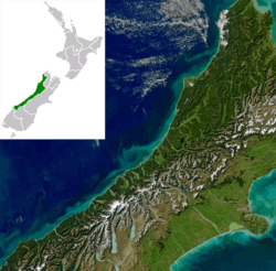
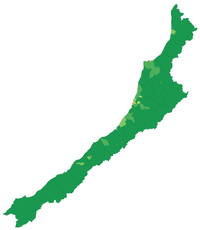
The West Coast (Māori: Te Tai Poutini) is a region of New Zealand on the west coast of the South Island that is administered by the West Coast Regional Council. It comprises the territorial authorities of Buller District, Grey District and Westland District. The principal towns are Westport, Greymouth, and Hokitika. The region is one of the more remote and most sparsely populated areas of the country.
West Coast Te Tai Poutini | |
|---|---|
 | |
| Coordinates: 42.6°S 171.4°E | |
| Country | New Zealand |
| Island | South Island |
| Constituent territorial authorities | |
| Government | |
| • Type | Regional council |
| • Body | West Coast Regional Council |
| • Chair | Andrew Robb |
| Area | |
| • Total | 23,276 km2 (8,987 sq mi) |
| Population (June 2019)[1] | |
| • Total | 32,600 |
| • Density | 1.4/km2 (3.6/sq mi) |
| HDI (2017) | 0.903[2] very high · 11th |
| Website | wcrc |
Naming
The name Westland is used by some New Zealanders to refer to the whole of the West Coast, including Grey District, Buller District and Fiordland, and can also refer to the short-lived Westland Province of 1873–76.
Fiordland is on the west coast, but is in the Southland Region rather than the West Coast Region.
Inhabitants of the West Coast are colloquially known as "Coasters".[3][4]
Geography
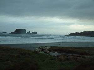
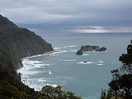
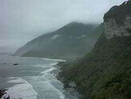
The region reaches from Kahurangi Point in the north to Awarua Point in the south, a distance of 600 km. To the west is the Tasman Sea (which like the Southern Ocean can be very rough, with four-metre swells common), and to the east are the Southern Alps. Much of the land is rugged, with a coastal plain where much of the population resides.
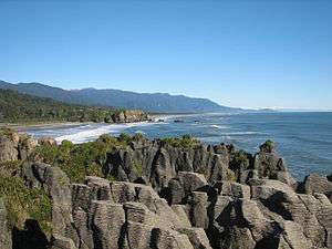
The land is very scenic, with wild coastlines, mountains and a very high proportion of native bush, much of it native temperate rain forest. It is the only part of New Zealand where significant tracts of lowland forest remain: elsewhere, for instance on the Canterbury Plains and in the Firth of Thames, they have been almost completely destroyed for settlement and agriculture. Scenic areas include the Haast Pass, Fox and Franz Josef Glaciers, Jordale Rocks, the Pancake Rocks at Punakaiki and the Heaphy Track.
The region has a very high rainfall due to the prevailing northwesterly wind pattern and the location of the Southern Alps, which give rise to heavy orographic precipitation. The rain shadow effect is responsible for the relatively arid climate of the Canterbury Plains on the other side of the Southern Alps.
Highways and passes include:
- State Highway 6.
- Lewis Pass.
- Arthur's Pass.
- Haast Pass.
Flights and train journeys into the region
- Flights operate daily with Air New Zealand between Christchurch and Hokitika.
- Flights operate daily with Sounds Air between Wellington and Westport.
- The TranzAlpine runs return between Christchurch and Greymouth on a daily basis.
| Climate data for Hokitika Airport (1936−2015, Humidity 1961−2015, Sunshine 1964−2015) | |||||||||||||
|---|---|---|---|---|---|---|---|---|---|---|---|---|---|
| Month | Jan | Feb | Mar | Apr | May | Jun | Jul | Aug | Sep | Oct | Nov | Dec | Year |
| Average high °C (°F) | 19.4 (66.9) |
19.8 (67.6) |
18.8 (65.8) |
16.6 (61.9) |
14.3 (57.7) |
12.3 (54.1) |
11.9 (53.4) |
12.6 (54.7) |
13.8 (56.8) |
14.9 (58.8) |
16.4 (61.5) |
18.2 (64.8) |
15.7 (60.3) |
| Average low °C (°F) | 11.7 (53.1) |
11.9 (53.4) |
10.7 (51.3) |
8.5 (47.3) |
6.0 (42.8) |
3.8 (38.8) |
2.9 (37.2) |
4.0 (39.2) |
5.8 (42.4) |
7.3 (45.1) |
8.7 (47.7) |
10.7 (51.3) |
7.7 (45.9) |
| Average rainfall mm (inches) | 242.3 (9.54) |
178.9 (7.04) |
215.0 (8.46) |
235.8 (9.28) |
242.1 (9.53) |
249.3 (9.81) |
219.3 (8.63) |
231.9 (9.13) |
256.5 (10.10) |
276.3 (10.88) |
239.6 (9.43) |
268.5 (10.57) |
2,849.7 (112.19) |
| Average rainy days (≥ 1.0 mm) | 12.4 | 10.4 | 12.6 | 13.3 | 14.7 | 13.8 | 13.5 | 14.8 | 16.8 | 17.3 | 15.0 | 15.8 | 170.5 |
| Mean monthly sunshine hours | 209.5 | 186.8 | 171.9 | 139.9 | 119.2 | 104.0 | 124.3 | 138.9 | 142.8 | 164.1 | 181.1 | 194.6 | 1,877 |
| Source: CliFlo[5] | |||||||||||||
The region's area is 23,276 km2. It is divided into the three districts of Buller, Grey and Westland.
History

The region is home to Ngāi Tahu, who value it for the greenstone (pounamu) found there in abundance.
The region was only occasionally visited by Europeans until the discovery of gold near the Taramakau River in 1864 by two Māori, Ihaia Tainui and Haimona Taukau. By the end of the year there were an estimated 1800 prospectors, many of them around the Hokitika area, which in 1866 was briefly the most populous settlement in New Zealand.
The region was divided between Nelson Province and Canterbury Province from 1853: in 1873 the Canterbury portion of the region formed its own province, the Westland Province, until the abolition of the provincial system in 1876.
The West Coast Gold Rush between 1864 and 1867 created numerous gold rush towns such as Okarito, which at one time was the largest town on the West Coast but quickly almost vanished as miners moved on. After that time, the population dwindled, but the main towns that still exist had become established.
Following greenstone and gold, the next valuable mineral was coal. Discovered near the Buller River in the mid-1840s, mining began in earnest during the 1860s. By the 1880s coal had become the region’s main industry, with mines throughout the northern half of the region, especially around Westport. Many of these continued in operation until the mid-20th century, and several survive.
Timber has also long been a major industry, although in recent years there has been an uneasy balance between forestry for wood and forestry for conservation. Much of the region is public land administered by the Department of Conservation and the region has some of the best remaining stands of native forest, along with a wealth of rare wildlife. Ecotourism is now an important industry, and this goes hand in hand with the conservation efforts.
Economy
Industries include mining for coal and alluvial gold, forestry and wood processing, fishing (including whitebaiting), tourism and farming. Dairy farming has grown strongly – the local dairy co-operative Westland Milk Products remained independent when most others merged to form Fonterra in 2001. Other industries are the manufacturing and sales of greenstone jewellery, sphagnum moss gathering and stone-collection for garden landscaping. Monteith's brewery is in Greymouth. The region had one of the strongest growing regional economies of New Zealand in 2007,[6] though from a rather small base.
The GDP of the region was estimated at NZ$1,848 million in 2019.[7]
The region has been included in the "Top 10 Coastal Drives of the World" by Lonely Planet.[8]
Population
The region is sparsely populated, especially in the south. The June 2019 population is 32,600.[1]
There are only five towns with a population over 1,000: Greymouth, Westport, Hokitika, Runanga and Reefton. During the gold rush days, Hokitika had a population of more than 25,000 with more than 100 pubs. A recreation of an early New Zealand settlement is at Shantytown.
| Urban area | Population (June 2019)[1] |
% of region |
|---|---|---|
| Greymouth | 8,160 | 25.0% |
| Westport | 4,660 | 14.3% |
| Hokitika | 3,090 | 9.5% |
| Runanga | 1,230 | 3.8% |
| Reefton | 1,010 | 3.1% |
| Historical population | ||
|---|---|---|
| Year | Pop. | ±% p.a. |
| 1991 | 31,563 | — |
| 1996 | 32,511 | +0.59% |
| 2001 | 30,303 | −1.40% |
| 2006 | 31,326 | +0.67% |
| 2013 | 32,148 | +0.37% |
| 2018 | 31,575 | −0.36% |
| Source: [9][10] | ||
The West Coast Region had a population of 31,575 at the 2018 New Zealand census, a decrease of 573 people (-1.8%) since the 2013 census, and an increase of 249 people (0.8%) since the 2006 census. There were 13,503 households. There were 16,041 males and 15,534 females, giving a sex ratio of 1.03 males per female. Of the total population, 5,604 people (17.7%) were aged up to 15 years, 4,920 (15.6%) were 15 to 29, 14,853 (47.0%) were 30 to 64, and 6,204 (19.6%) were 65 or older. Figures may not add up to the total due to rounding.
Ethnicities were 90.5% European/Pākehā, 11.7% Māori, 1.5% Pacific peoples, 3.4% Asian, and 2.4% other ethnicities. People may identify with more than one ethnicity.
The percentage of people born overseas was 12.0, compared with 27.1% nationally.
Although some people objected to giving their religion, 53.2% had no religion, 35.1% were Christian, and 3.1% had other religions.
Of those at least 15 years old, 2,934 (11.3%) people had a bachelor or higher degree, and 7,026 (27.1%) people had no formal qualifications. The median income was $26,400. The employment status of those at least 15 was that 12,501 (48.1%) people were employed full-time, 4,083 (15.7%) were part-time, and 822 (3.2%) were unemployed.[9]
Flora and fauna
The region has the only New Zealand nesting place of the kotuku (white heron), near Okarito Lagoon, visited by tours from the small farming township of Whataroa. This rare bird appears on the $2 coin.[11]
References
- "Subnational Population Estimates: At 30 June 2019". Statistics New Zealand. 22 October 2019. Retrieved 11 January 2020.
- "Sub-national HDI - Area Database - Global Data Lab". hdi.globaldatalab.org. Retrieved 13 September 2018.
- West Coast – Regional Information (from 'New Zealand Tourism Online' website)
- The West Coast New Zealand (from 'A New Zealand Travel Guide' website)
- "CliFlo - National Climate Database". NIWA. Retrieved 13 December 2015.
- History (from the Buller District Council website)
- "West Coast Gross Domestic Product". Infometrics. Infometrics. 2019. Retrieved 6 February 2020.
- "West Coast, New Zealand official site: Find activities, accommodation, events". Westcoastnz.com. Retrieved 16 October 2012.
- "Statistical area 1 dataset for 2018 Census". Statistics New Zealand. March 2020. West Coast Region (12). 2018 Census place summary: West Coast Region
- "2001 Census: Regional summary". archive.stats.govt.nz. Retrieved 28 April 2020.
- New Zealand Coinage Specifications (from the Reserve Bank of New Zealand website. Accessed 2008-03-26.)
External links
| Wikivoyage has a travel guide for West Coast (New Zealand). |
| Wikimedia Commons has media related to West Coast Region. |
- West Coast Regional Council
- West Coast New Zealand
- Development West Coast
- Map (1900s) of West Coast
- "West Coast Conservation Management Strategy Volume 1 2010-2020". Department of Conservation. 2010.
- West Coast Marine Protection Forum
| North Island | ||
|---|---|---|
| South Island | ||
* Governed by a unitary authority rather than a regional council | ||