Waitākere Ranges
The Waitākere Ranges and its foothills and coasts comprise an area of some 27 720 ha of public and private land located between metropolitan Auckland and the west coast of Waitakere City and Rodney District. The area is of local, regional, and national significance.[1] The Waitākere Ranges include a chain of hills in the Auckland Region, generally running approximately 25 km (15.5 mi) from north to south, 25 km west of central Auckland, New Zealand. The Waitākere Ranges are part of the Waitākere Ranges regional park.[2] The ranges and surrounding areas were traditionally known to local Māori as Te Wao Nui o Tiriwa (The Great Forest of Tiriwa).
From 1 May 2018 the forested areas of the Waitākere Ranges Regional Park were closed, with some exceptions while Auckland Council upgraded the tracks to dry foot standard to prevent the spread of potential disease and protect tree roots.[3] But many are now marked as permanently closed and their future is uncertain.
Topography

The western coastline of the ranges consists of cliffs exceeding 300 m (984 ft), interspersed infrequently with beaches. The rugged upstanding topography is formed from erosion-resistant ancient volcanic conglomerate and lava flows laid down in eruptions from the large Waitakere volcano to the west 12–25 million years ago.[4] The ranges are covered in native forest, most of which is in the process of regeneration since extensive logging and farming in the mid–late 19th and early 20th centuries.
The highest point in the Waitākere Ranges (474 metres (1,555 ft)) is Te Toiokawharu. This is located in the southern part of the ranges, about 3 km north-east of Huia.
Regional Park
The Waitākere Ranges Regional Park, protected at local, regional, and national levels, is an area of some 17 000 ha, established over a period of 110 years through gifts, grants, purchases, and vestings (including legislation promoted by Auckland City Council in 1941 to create the Auckland Centennial Memorial Park, commemorating the centenary of the Metropolitan District of Auckland).[1]
In 1894 a group led by Sir Algernon Thomas (the first professor of natural sciences at Auckland University College, now the University of Auckland) persuaded the Auckland City Council to preserve 3,500 acres (14 km2) in the Nihotupu area of the ranges as a bush reserve. In 1895 the national Government vested the land, and several other smaller areas of the ranges, in the City Council as "reserves for the conservation of native flora and fauna". The Waitākere Ranges Regional Park now contains about 39,500 acres (160 km2).[5] The area is also protected under the Waitākere Ranges Heritage Area Act of 2008.[6]
Attractions
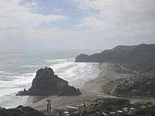
Some of the ranges' main attractions are: the four popular surf beaches, Piha, Muriwai, Te Henga (Bethells Beach), Karekare; an extensive network of bush walks and tracks;[5] and panoramic views of the east and west coasts and the city. A road, aptly named Scenic Drive, runs a good portion of the length of the ranges from Titirangi to Swanson. Auckland City Council operates an information centre on Scenic Drive, called Arataki Visitor Centre.[7]
The beaches are typical of west coast beaches north of Taranaki in that they are all black sand beaches. They have a reputation of being dangerous for swimmers due to rips and large swells. Surf Life Saving Clubs patrol designated areas of the four most popular beaches during the summer months. Piha Surf Life Saving Club is the oldest of these, being founded in 1934.
On 11 January 2010, the Auckland Regional Council opened the Hillary Trail, a 77 km trail running roughly south–north from the Arataki Visitor Centre to Muriwai through the Waitākere Ranges, named in honour of the New Zealand mountaineer Sir Edmund Hillary.[8] The Hilary Trail is regarded as one of or maybe the best multi day hike in the north of the country.[9]
Reservoirs
Five reservoirs within the ranges supply water to the Auckland region, including the Waitākere Reservoir and the Lower Nihotupu Reservoir.[5] Combined, the reservoirs supply approximately 26% of Auckland's potable water demand. The ranges receive an average of over 2,000 mm (78.75 inches) of rainfall annually while the corresponding rate in the city is less than half that.[10] As weather systems approach across the Tasman Sea, their path is blocked by the ranges causing a small uplift sufficient to trigger orographic rainfall.
Fauna
The area is home to kauri snails, glowworms and native long-tailed bats. Long-tailed and short-tailed bats are New Zealand's only native land-based mammals. At the northern end of the ranges, Otakamiro Point is the site of one of New Zealand's few mainland gannet breeding colonies. In the bush are many indigenous invertebrates, including kauri snail, weta and oviparous velvet worms with 14 pairs of legs, and ovoviviparous species of 15 and 16 pairs of legs in the genus Peripatoides.
The Ark in the Park conservation initiative, a partnership between Forest and Bird and the Auckland Council, is working to reintroduce some of the species made extinct in the Cascades Kauri Park section of the ranges. The project was started in 2003 and now covers 2,300 hectares (5,700 acres).[11]
Demographics
| Historical population | ||
|---|---|---|
| Year | Pop. | ±% p.a. |
| 2006 | 2,037 | — |
| 2013 | 2,151 | +0.78% |
| 2018 | 2,385 | +2.09% |
| Source: [12] | ||
The statistical areas of Waitakere Ranges North and Waitakere Ranges South, which include the populated areas of Huia and Karekare but not Piha or Te Henga (Bethells Beach), had a population of 2,385 at the 2018 New Zealand census, an increase of 234 people (10.9%) since the 2013 census, and an increase of 348 people (17.1%) since the 2006 census. There were 873 households. There were 1,206 males and 1,179 females, giving a sex ratio of 1.02 males per female, with 456 people (19.1%) aged under 15 years, 396 (16.6%) aged 15 to 29, 1,230 (51.6%) aged 30 to 64, and 300 (12.6%) aged 65 or older.
Ethnicities were 92.3% European/Pākehā, 12.5% Māori, 4.2% Pacific peoples, 3.6% Asian, and 1.6% other ethnicities (totals add to more than 100% since people could identify with multiple ethnicities).
The proportion of people born overseas was 20.8%, compared with 27.1% nationally.
Although some people objected to giving their religion, 69.6% had no religion, 19.5% were Christian, and 4.9% had other religions.
Of those at least 15 years old, 552 (28.6%) people had a bachelor or higher degree, and 216 (11.2%) people had no formal qualifications. The employment status of those at least 15 was that 1,038 (53.8%) people were employed full-time, 354 (18.4%) were part-time, and 57 (3.0%) were unemployed.[12]
References
- "Waitākere Ranges Heritage Area Act".
- "Regional Parks Management Plan" (PDF). Auckland Council.
- "Kauri Dieback Disease Auckland Council Park Rangers". Stuff.
- Hayward, Bruce W. (1979). "Eruptive history of the early to mid miocene Waitakere volcanic arc, and palaeogeography of the Waitemata Basin, Northern New Zealand". Journal of the Royal Society of New Zealand. 9 (3): 297–320. doi:10.1080/03036758.1979.10419410. ISSN 0303-6758.
- Our parks - Waitākere Ranges, Auckland Regional Council. Accessed 13 April 2009.
- Waitākere Ranges Heritage Area Act 2008 (PDF)
- Arataki Visitor Centre
- "The Hillary Trail". Auckland Council Regional Parks.
- "Hillary Trail Auckland". New Zealand Experience.
- "Rainfall". Auckland Regional Council.
- Pratt, Ciara (13 January 2013). "Waitakere Ranges Sanctuary To Re-Introduce Kiwi". Western Leader. Stuff.co.nz. Retrieved 14 February 2013.
- "Statistical area 1 dataset for 2018 Census". Statistics New Zealand. March 2020. Waitakere Ranges North (117100) and Waitakere Ranges South (128000). 2018 Census place summary: Waitakere Ranges North 2018 Census place summary: Waitakere Ranges South
External links
| Wikimedia Commons has media related to Waitakere Ranges. |