Dunedin
Dunedin (/dʌˈniːdɪn/ (![]()
Dunedin Ōtepoti (Māori) | |
|---|---|
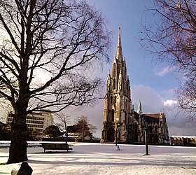
 Clockwise from top: First Church of Otago, cityscape seen from Signal Hill lookout, Larnach Castle, Anglican Cathedral and Town Hall on The Octagon | |
 Flag  Coat of arms | |
| Nicknames: | |
| Coordinates: 45°52′S 170°30′E | |
| Country | New Zealand |
| Region | Otago |
| Territorial authority | Dunedin City Council |
| Settled by Māori | c. 1300[3] |
| Settled by Europeans | 1848 |
| Incorporated[4] | 1855 |
| Named for | Dùn Èideann – Scottish Gaelic name for Edinburgh |
| Electorates | Dunedin North Dunedin South |
| Government | |
| • Mayor | Aaron Hawkins (Green) |
| • Deputy Mayor | Christine Garey |
| Area | |
| • Territorial | 3,314 km2 (1,280 sq mi) |
| • Urban | 255 km2 (98 sq mi) |
| Population (June 2019)[6] | |
| • Territorial | 131,700 |
| • Density | 40/km2 (100/sq mi) |
| • Urban | 104,500 |
| • Urban density | 410/km2 (1,100/sq mi) |
| Demonym(s) | Dunedinite |
| Time zone | UTC+12 (NZST) |
| • Summer (DST) | UTC+13 (NZDT) |
| Postcodes | 9010, 9011, 9012, 9013, 9014, 9016, 9018, 9022, 9023, 9024, 9035, 9076, 9077, 9081, 9082, 9092 |
| Area code(s) | 03 |
| Local iwi | Ngāi Tahu |
| Website | www.DunedinNZ.com |
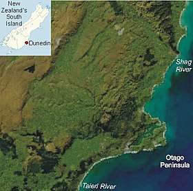
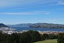
The urban area of Dunedin lies on the central-eastern coast of Otago, surrounding the head of Otago Harbour, and the harbour and hills around Dunedin are the remnants of an extinct volcano. The city suburbs extend out into the surrounding valleys and hills, onto the isthmus of the Otago Peninsula, and along the shores of the Otago Harbour and the Pacific Ocean. Dunedin was the largest New Zealand city by territorial land area until superseded by Auckland with the formation of the Auckland Council in November 2010.
Archaeological evidence points to lengthy occupation of the area by Māori prior to the arrival of Europeans. The province and region of Otago takes its name from the Ngāi Tahu village of Otakou at the mouth of the harbour,[9] which became a whaling station in the 1830s.
In 1848 a Scottish settlement was established by the Lay Association of the Free Church of Scotland. Between 1855 and 1900 many thousands of Scots emigrated to the incorporated city. Dunedin became wealthy during the Central Otago Gold Rush, beginning in the 1860s. In the mid-1860s, and between 1878 and 1881, it was New Zealand's largest urban area. The city population at 5 March 2013 was 120,246.[10] While Hamilton, Tauranga and Lower Hutt have eclipsed the city in size of population since the 1980s to make it only the seventh-largest urban area in New Zealand, Dunedin is still considered one of the four main cities of New Zealand for historic, cultural and geographic reasons.[lower-alpha 1]
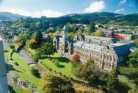
Dunedin has a diverse economy, which includes manufacturing, publishing and technology-based industries as well as education, research and tourism. The city's most important activity centres around tertiary education—Dunedin is home to the University of Otago, New Zealand's oldest university (established 1869), and the Otago Polytechnic. Students account for a large proportion of the population; 21.6 per cent of the city's population was aged between 15 and 24 at the 2006 census, compared to the New Zealand average of 14.2 per cent.[18] In 2014 Dunedin was designated as a UNESCO City of Literature.[19]
History
Māori settlements
Archaeological evidence shows the first human (Māori) occupation of New Zealand occurred between 1250–1300 AD,[3] with population concentrated along the southeast coast.[20][21][22] A camp site at Kaikai Beach, near Long Beach to the north of the present-day city of Dunedin, has been dated from about that time.[23] There are numerous archaic (moa-hunter) sites in what is now Dunedin, several of them large and permanently occupied, particularly in the 14th century.[20][21] The population contracted but expanded again with the evolution of the Classic Māori culture which saw the building of several pā, fortified settlements, notably Pukekura at (Taiaroa Head), about 1650.[22] There was a settlement in what is now central Dunedin (Ōtepoti), occupied as late as about 1785 but abandoned by 1826.[24][25] There were also Maori settlements at Whareakeake (Murdering Beach), Purakaunui, Mapoutahi (Goat Island Peninsula) and Huriawa (Karitane Peninsula) to the north, and at Taieri Mouth and Otokia (Henley) to the south, all inside the present boundaries of Dunedin.
Māori tradition tells first of a people called Kahui Tipua living in the area, then Te Rapuwai, semi-legendary but considered to be historical. The next arrivals were Waitaha, followed by Kāti Māmoe late in the 16th century and then Kai Tahu (Ngāi Tahu in modern standard Māori) who arrived in the mid-17th century.[26] European accounts have often represented these successive influxes as "invasions", but modern scholarship has cast doubt on that view. They were probably migrations - like those of the Europeans - which incidentally resulted in bloodshed.[22][23] The sealer John Boultbee recorded in the late 1820s that the 'Kaika Otargo' (settlements around and near Otago Harbour) were the oldest and largest in the south.[27]
European settlement
Lieutenant James Cook stood off what is now the coast of Dunedin between 25 February 1770 and 5 March 1770, naming Cape Saunders (on the Otago Peninsula) and Saddle Hill. He reported penguins and seals in the vicinity, which led sealers to visit from the beginning of the 19th century.[28] The early years of sealing saw a feud between sealers and local Māori from 1810 to 1823, the "Sealers' War" sparked by an incident on Otago Harbour, but William Tucker became the first European to settle in the area in 1815.[25]
Permanent European occupation dates from 1831, when the Weller brothers founded their whaling station at Otago, modern Otakou, on the Otago Harbour. Epidemics badly reduced the Māori population. By the late 1830s the Harbour had become an international whaling port. Wright & Richards started a whaling station at Karitane in 1837 and Johnny Jones established a farming settlement and a mission station, the South Island's first, at Waikouaiti in 1840.[29] The settlements at Karitane and Waikouaiti have endured making modern Dunedin one of the longest European settled territories in New Zealand.
In 1844, the Deborah, captained by Thomas Wing and carrying (among others) his wife Lucy and a representative of the New Zealand Company, Frederick Tuckett, sailed south to determine the location of a planned Free Church settlement.[30] After inspecting several areas around the eastern coast of the south island, Tuckett selected the site which would become known as Dunedin.[31] (Tuckett turned down the site which would become Christchurch, as he felt the ground around the Avon river was swampy.[32])
The Lay Association of the Free Church of Scotland, through a company called the Otago Association, founded Dunedin at the head of Otago Harbour in 1848 as the principal town of its special settlement.[33]
The name Dunedin comes from Dùn Èideann, the Scottish Gaelic name for Edinburgh, the capital of Scotland.[26] Charles Kettle the city's surveyor, instructed to emulate the characteristics of Edinburgh, produced a striking, "Romantic" design.[34] There resulted both grand and quirky streets as the builders struggled and sometimes failed to construct his bold vision across the challenging landscape. Captain William Cargill, a veteran of the Napoleonic Wars, served as the secular leader of the new colony. The Reverend Thomas Burns, a nephew of the poet Robert Burns, provided spiritual guidance. By the end of the 1850s, around 12,000 Scots had emigrated to Dunedin, many from the industrial lowlands.[33]
Gold rush era
In 1852, Dunedin became the capital of the Otago Province, the whole of New Zealand from the Waitaki south. In 1861 the discovery of gold at Gabriel's Gully, to the south-west, led to a rapid influx of people and saw Dunedin become New Zealand's first city by growth of population in 1865. The new arrivals included many Irish, but also Italians, Lebanese, French, Germans, Jews and Chinese.[26][35] The Dunedin Southern Cemetery was established in 1858, the Dunedin Northern Cemetery in 1872.[36]
The London-owned Bank of Otago opened its doors in Dunedin in 1863, opened 12 branches throughout its region then in 1873 merged with the new National Bank of New Zealand also based in London and also operated from Dunedin but, true to its name, it rapidly expanded throughout New Zealand.[37] Dunedin remained the principal local source of the nation's development capital until the second world war.
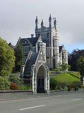
Dunedin and the region industrialised and consolidated and the Main South Line connected the city with Christchurch in 1878 and Invercargill in 1879. Otago Boys' High School was founded in 1863. The Otago Museum opened in 1868. The University of Otago, the oldest university in New Zealand, in 1869.[38] Otago Girls' High School was established in 1871.
Between 1881 and 1957, Dunedin was home to cable trams, being both one of the first and last such systems in the world. Early in the 1880s the inauguration of the frozen meat industry, with the first shipment leaving from Port Chalmers in 1882, saw the beginning of a later great national industry.[39]
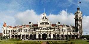
After ten years of gold rushes the economy slowed but Julius Vogel's immigration and development scheme brought thousands more especially to Dunedin and Otago before recession set in again in the 1880s. In these first and second times of prosperity many institutions and businesses were established, New Zealand's first daily newspaper, art school, medical school and public art gallery the Dunedin Public Art Gallery among them.[26][35][40] There was also a remarkable architectural flowering producing many substantial and ornamental buildings. R. A. Lawson's First Church of Otago and Knox Church are notable examples, as are buildings by Maxwell Bury and F. W. Petre. The other visual arts also flourished under the leadership of W. M. Hodgkins.[40] The city's landscape and burgeoning townscape were vividly portrayed by George O'Brien (1821–1888).[41] From the mid-1890s the economy revived. Institutions such as the Otago Settlers Museum (now renamed as Toitu Otago Settlers Museum) and the Hocken Collections—the first of their kind in New Zealand—were founded. More notable buildings such as the Railway Station and Olveston were erected. New energy in the visual arts represented by G. P. Nerli culminated in the career of Frances Hodgkins.[40][42][43][44]
Early modern era
By 1900, Dunedin was no longer the country's biggest city. Influence and activity moved north to the other centres ("the drift north"), a trend which continued for much of the following century. Despite this, the university continued to expand, and a student quarter became established. At the same time people started to notice Dunedin's mellowing, the ageing of its grand old buildings, with writers like E. H. McCormick pointing out its atmospheric charm.[45] In the 1930s and early 1940s a new generation of artists such as M. T. (Toss) Woollaston, Doris Lusk, Anne Hamblett, Colin McCahon and Patrick Hayman once again represented the best of the country's talent. The Second World War saw the dispersal of these painters, but not before McCahon had met a very youthful poet, James K. Baxter, in a central city studio.

Numerous large companies had been established in Dunedin, many of which became national leaders. Late among them was Fletcher Construction, founded by Sir James Fletcher in the early 20th century. Kempthorne Prosser, established in 1879 in Stafford Street, was the largest fertiliser and drug manufacturer in the country for over 100 years. G. Methven, a metalworking and tap manufacturer based in South Dunedin, was also a leading firm, as was H. E. Shacklock, an iron founder and appliance manufacturer later taken over by the Auckland concern Fisher and Paykel. The Mosgiel Woollens was another Victorian Dunedin foundation. Hallensteins was the colloquial name of a menswear manufacturer and national retail chain while the DIC and Arthur Barnett were department stores, the former a nationwide concern. Coulls, Somerville Wilkie—later part of the Whitcoulls group—had its origins in Dunedin in the 19th century. There were also the National Mortgage and Agency Company of New Zealand, Wright Stephensons Limited, the Union Steamship Company and the National Insurance Company and the Standard Insurance Company among many others, which survived into the 20th century.
Post-war developments
After the Second World War prosperity and population growth revived, although Dunedin trailed as the fourth 'main centre'. A generation reacting against Victorianism started demolishing its buildings and many were lost, notably William Mason's Stock exchange in 1969. (Dunedin Stock Exchange building) Although the university continued to expand, the city's population contracted, notably from 1976 to 1981. This was, however, a culturally vibrant time with the university's new privately endowed arts fellowships bringing such luminaries as James K Baxter, Ralph Hotere, Janet Frame and Hone Tuwhare to the city.
.jpg)
During the 1980s Dunedin's popular music scene blossomed, with many acts, such as The Chills, The Clean, The Verlaines and Straitjacket Fits, gaining national and international recognition. The term "The Dunedin sound" was coined to describe the 1960s-influenced, guitar-led music which flourished at the time.[46] Bands and musicians are still playing and recording in many styles.
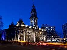
By 1990, population decline had steadied and slow growth has occurred since and Dunedin re-invented itself as a 'heritage city' with its main streets refurbished in Victorian style.[47] R. A. Lawson's Municipal Chambers (Dunedin Town Hall) in the Octagon were handsomely restored. The city was also recognised as a centre of excellence in tertiary education and research. The university's and polytechnic's growth accelerated. Dunedin has continued to refurbish itself, embarking on redevelopments of the art gallery, railway station and the Toitū Otago Settlers Museum.
Dunedin has flourishing niche industries including engineering, software engineering, bio-technology and fashion. Port Chalmers on the Otago Harbour provides Dunedin with deep-water facilities. It is served by the Port Chalmers Branch, a branch line railway which diverges from the Main South Line and runs from Christchurch by way of Dunedin to Invercargill. Dunedin is also home to MTF, the nationwide vehicle finance company.
The cityscape glitters with gems of Victorian and Edwardian architecture—the legacy of the city's gold-rush affluence. Many, including First Church, Otago Boys' High School and Larnach Castle were designed by one of New Zealand's most eminent architects R. A. Lawson. Other prominent buildings include Olveston and the Dunedin Railway Station. Other unusual or memorable buildings or constructions are Baldwin Street, claimed to be the world's steepest residential street;[48] the Captain Cook tavern; Cadbury Chocolate Factory (Cadbury World); and the local Speight's brewery.
Dunedin is also a centre for ecotourism. The world's only mainland royal albatross colony and several penguin and seal colonies lie within the city boundaries on the Otago Peninsula. To the north of the city, above Waitati, is the 307 ha Orokonui Ecosanctuary, a ‘mainland island’, where rare species of wildlife – birds, lizards and plants – have been reintroduced and now thrive in the predator-free environment. To the south, on the western side of Lake Waihola, are the Sinclair Wetlands.
The thriving tertiary student population has led to a vibrant youth culture (students are referred to as 'Scarfies' by people who are not students), consisting of the previously mentioned music scene, and more recently a burgeoning boutique fashion industry.[49][50] A strong visual arts community also exists in Dunedin, notably in Port Chalmers and the other settlements which dot the coast of the Otago Harbour, and also in communities such as Waitati.
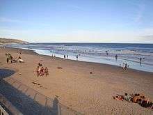
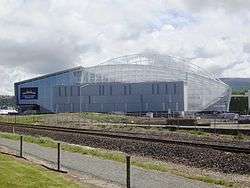
Sport is catered for in Dunedin by the floodlit rugby and cricket venues of Forsyth Barr Stadium and University Oval, Dunedin, respectively, the new Caledonian Ground football and athletics stadium near the University at Logan Park, the large Edgar Centre indoor sports centre, the Dunedin Ice Stadium, and numerous golf courses and parks. There are also the Forbury Park horseracing circuit in the south of the city and several others within a few kilometres. St Clair Beach is a well-known surfing venue, and the harbour basin is popular with windsurfers and kitesurfers. Dunedin has four public swimming pools: Moana Pool, Port Chalmers Pool, Mosgiel and St Clair Salt Water Pool.
On 16 July 2019, the Dunedin street Baldwin Street lost its title of World's Steepest Street to Ffordd Pen Llech in Wales; with Baldwin Street being at a gradient of 35%, and Ffordd Pen Llech being at a gradient of 37.45%. Hitherto, Baldwin Street had held the title of the World's Steepest Street since 1987.[51][52][53]
Geography
Dunedin City has a land area of 3,314.8 km2 (1,279.9 sq mi), slightly larger than the American state of Rhode Island or the English county of Cambridgeshire, and a little smaller than Cornwall. It was the largest city in land area in New Zealand until the formation of the 5,600 km2 (2,200 sq mi) Auckland Council on 1 November 2010. The Dunedin City Council boundaries since 1989 have extended to Middlemarch in the west, Waikouaiti in the north, the Pacific Ocean in the east and south-east, and the Waipori/Taieri River and the township of Henley in the south-west.
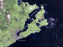
Dunedin is situated at the head of Otago Harbour, a narrow inlet extending south-westward for some 15 miles. The harbour is a recent creation formed by the flooding of two river valleys.[54] From the time of its foundation in 1848, the city has spread slowly over the low-lying flats and nearby hills and across the isthmus to the slopes of the Otago Peninsula.
Inner city

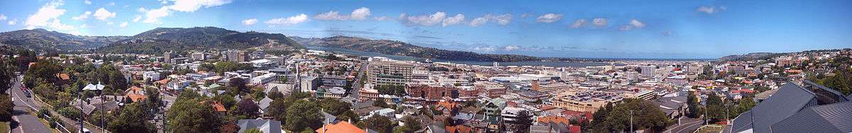
The central region of Dunedin is known as the Octagon. It was once a gully, filled in the mid nineteenth century to create the present plaza. The initial settlement of the city took place to the south on the other side of Bell Hill, a large outcrop which had to be reduced to provide easy access between the two parts of the settlement. The central city stretches away from this point in a largely northeast-southwest direction, with the main streets of George Street and Princes Street meeting at The Octagon. Here they are joined by Stuart Street, which runs orthogonally to them, from the Dunedin Railway Station in the southeast, and steeply up to the suburb of Roslyn in the northwest. Many of the city's notable old buildings are located in the southern part of this area and on the inner ring of lower hills which surround the central city (most of these hills, such as Maori Hill, Pine Hill, and Maryhill, rise to some 200 metres [660 ft] above the plain). The head of the harbour includes a large area of reclaimed land ("The Southern Endowment"), much of which is used for light industry and warehousing. A large area of flat land, simply known colloquially as "The Flat" lies to the south and southwest of the city centre, and includes several larger and older suburbs, notably South Dunedin and St. Kilda. These are protected from the Pacific Ocean by a long line of dunes which run east-west along the city's southern coastline and separate residential areas from Ocean Beach, which is traditionally divided into St. Clair Beach at the western end and St. Kilda Beach to the east.
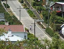
Dunedin is home to Baldwin Street, which, according to the Guinness Book of Records, is the steepest street in the world. Its gradient is 1 in 2.9.[55] The long-since-abandoned Maryhill Cablecar route had a similar gradient close to its Mornington depot.
Beyond the inner range of hills lie Dunedin's outer suburbs, notably to the northwest, beyond Roslyn. This direction contains Taieri Road and Three Mile Hill, which between them formed the original road route to the Taieri Plains. The modern State Highway 1 follows a different route, passing through Caversham in the west and out past Saddle Hill. Lying between Saddle Hill and Caversham are the outer suburbs of Green Island and Abbotsford. Between Green Island and Roslyn lies the steep-sided valley of the Kaikorai Stream, which is today a residential and light industrial area. Suburban settlements—mostly regarded as separate townships—also lie along both edges of the Otago Harbour. Notable among these are Portobello and Macandrew Bay, on the Otago Peninsula coast, and Port Chalmers on the opposite side of the harbour. Port Chalmers provides Dunedin's main deep-water port, including the city's container port.
The Dunedin skyline is dominated by a ring of (traditionally seven) hills which form the remnants of a volcanic crater. Notable among them are Mount Cargill (700 m [2,300 ft]), Flagstaff (680 m [2,230 ft]), Saddle Hill (480 m [1,570 ft]), Signal Hill (390 m [1,280 ft]), and Harbour Cone (320 m [1,050 ft]).[56]
Hinterland
Dunedin's hinterland encompasses a variety of different landforms. To the southwest lie the Taieri Plains, the broad, fertile lowland floodplains of the Taieri River and its major tributary the Waipori. These are moderately heavily settled, and contain the towns of Mosgiel, and Allanton.[56] They are separated from the coast by a range of low hills rising to some 300 metres (980 ft). Inland from the Taieri Plain is rough hill country. Close to the plain, much of this is forested, notably around Berwick and Lake Mahinerangi, and also around the Silverpeaks Range which lies northwest of the Dunedin urban area.[57] Beyond this, the land becomes drier and opens out into grass and tussock-covered land. A high, broad valley, the Strath-Taieri lies in Dunedin's far northwest, containing the town of Middlemarch, one of the area's few concentrations of population.
To the north of the city's urban area is undulating hill country containing several small, mainly coastal, settlements, including Waitati, Warrington, Seacliff, and Waikouaiti. State Highway 1 winds steeply through a series of hills here, notably The Kilmog.[56] These hills can be considered a coastal extension of the Silverpeaks Range.
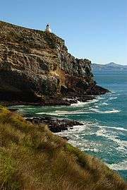
To the east, Dunedin City includes the entirety of the Otago Peninsula, a long finger of land that formed the southeastern rim of the Dunedin Volcano.[56] The peninsula is lightly settled, almost entirely along the harbour coast, and much of it is maintained as a natural habitat by the Otago Peninsula Trust. The peninsula contains several fine beaches, and is home to a considerable number of rare species, such as yellow-eyed and little penguins, seals, and shags. Most importantly, it contains the world's only mainland breeding colony of royal albatross, at Taiaroa Head on the peninsula's northeastern point.
List of suburbs
- Inner suburbs
(clockwise from the city centre, starting at due north)
Woodhaugh; Glenleith; Leith Valley; Dalmore; Liberton; Pine Hill; Normanby; Mt Mera; North East Valley; Opoho; Dunedin North; Ravensbourne; Highcliff; Shiel Hill; Challis; Waverley; Vauxhall; Ocean Grove (Tomahawk); Tainui; Andersons Bay; Musselburgh; South Dunedin; St Kilda; St Clair; Corstorphine; Kew; Forbury; Caversham; Concord; Maryhill; Kenmure; Mornington; Kaikorai Valley; City Rise; Belleknowes; Roslyn; Kaikorai; Wakari; Maori Hill.
- Outer suburbs
(clockwise from the city centre, starting at due north)
Burkes; Saint Leonards; Deborah Bay; Careys Bay; Port Chalmers; Sawyers Bay; Roseneath; Broad Bay; Company Bay; Macandrew Bay; Portobello; Burnside; Green Island; Waldronville; Brighton; Westwood; Saddle Hill; Sunnyvale; Fairfield; Mosgiel; Abbotsford; Bradford; Brockville; Halfway Bush; Helensburgh.
Towns within city limits
(clockwise from the city centre, starting at due north)
Waitati; Waikouaiti; Karitane; Seacliff; Warrington; Purakanui; Long Beach; Aramoana; Otakou; Taieri Mouth; Henley; Allanton; East Taieri; Momona; Outram; West Taieri; Waipori; Middlemarch; Hyde.
Since local council reorganisation in the late 1980s, these are suburbs, but are not commonly regarded as such.
Climate
The climate of Dunedin in general is temperate; however, the city is recognised as having a large number of microclimates and the weather conditions often vary between suburbs mostly due to the city's topographical layout. Under the Köppen climate classification, Dunedin features an oceanic climate. The city's climate is also greatly modified by its proximity to the ocean. This leads to mild summers and cool winters. Winter is frosty but sunny, snowfall is common but significant snowfall is uncommon (perhaps every two or three years), except in the inland hill suburbs such as Halfway Bush and Wakari, which tend to receive a few days of snowfall each year. Spring can feature "four seasons in a day" weather, but from November to April it is generally settled and mild. Temperatures during summer can briefly reach 30 °C (86 °F). Due to its extreme maritime influence, Dunedin's cool summers and mild winters both stand out considering its latitude.
Dunedin has relatively low rainfall in comparison to many of New Zealand's cities, with only some 750 millimetres (30 in) recorded per year. Despite this fact it is sometimes misguidedly regarded as a damp city, probably due to its rainfall occurring in drizzle or light rain (heavy rain is relatively rare). Dunedin is one of the cloudiest major centres in the country, recording approximately 1,650 hours of bright sunshine per annum.[58] Prevailing wind in the city is mainly a sometimes cool southwesterly and during late spring will alternate with northeasterlies.[59] Warmer, dry northwest winds are also characteristic Foehn winds from the northwest. The circle of hills surrounding the inner city shelters the inner city from much of the prevailing weather, while hills just to the west of the city can often push inclement weather around to the west of the city.
Inland, beyond the heart of the city and into inland Otago the climate is sub-continental: winters are quite cold and dry, summers warm and dry. Thick freezing ground fogs are common in winter in the upper reaches of the Taieri River's course around Middlemarch, and in summer the temperature occasionally reaches 30 °C (86 °F).
| Climate data for Dunedin (1981–2010) | |||||||||||||
|---|---|---|---|---|---|---|---|---|---|---|---|---|---|
| Month | Jan | Feb | Mar | Apr | May | Jun | Jul | Aug | Sep | Oct | Nov | Dec | Year |
| Average high °C (°F) | 18.9 (66.0) |
18.6 (65.5) |
17.3 (63.1) |
15.3 (59.5) |
12.7 (54.9) |
10.6 (51.1) |
10.0 (50.0) |
11.2 (52.2) |
13.2 (55.8) |
14.7 (58.5) |
16.1 (61.0) |
17.3 (63.1) |
14.6 (58.3) |
| Daily mean °C (°F) | 15.3 (59.5) |
15.0 (59.0) |
13.7 (56.7) |
11.7 (53.1) |
9.3 (48.7) |
7.3 (45.1) |
6.6 (43.9) |
7.7 (45.9) |
9.5 (49.1) |
10.9 (51.6) |
12.4 (54.3) |
13.9 (57.0) |
11.1 (52.0) |
| Average low °C (°F) | 11.6 (52.9) |
11.5 (52.7) |
10.2 (50.4) |
8.2 (46.8) |
5.9 (42.6) |
4.0 (39.2) |
3.1 (37.6) |
4.2 (39.6) |
5.9 (42.6) |
7.2 (45.0) |
8.6 (47.5) |
10.4 (50.7) |
7.6 (45.7) |
| Average precipitation mm (inches) | 72.9 (2.87) |
67.8 (2.67) |
64.0 (2.52) |
50.9 (2.00) |
64.7 (2.55) |
57.9 (2.28) |
57.1 (2.25) |
55.7 (2.19) |
48.3 (1.90) |
61.7 (2.43) |
56.4 (2.22) |
80.2 (3.16) |
737.6 (29.04) |
| Average precipitation days (≥ 1.0 mm) | 9.7 | 8.5 | 8.9 | 8.3 | 9.8 | 9.4 | 9.3 | 9.6 | 8.7 | 10.1 | 10.0 | 12.0 | 114.2 |
| Average relative humidity (%) | 74.2 | 77.6 | 77.1 | 76.9 | 79.5 | 79.7 | 80.2 | 77.6 | 72.1 | 71.6 | 70.6 | 73.2 | 75.9 |
| Mean monthly sunshine hours | 179.6 | 158.0 | 146.1 | 125.9 | 108.4 | 95.3 | 110.6 | 122.2 | 136.8 | 165.5 | 166.9 | 168.3 | 1,683.7 |
| Source: NIWA Climate Data[60] | |||||||||||||
Demographics
The city has a population of 131,700 (June 2019).[6] Compared to New Zealand as a whole, Dunedin's demographics tend to show traits of the New Zealand education sector, largely caused by the city's high tertiary student population. These traits include a higher female population compared to males, a lower-than-average median age, a high proportion of people under 25 years, a higher proportion of people of European and Asian ethnicity and a lower proportion of Māori and Pacific Island ethnicities, higher unemployment, lower median income, and a higher proportion of those with school and post-school qualifications.[18]
| Historical population | ||
|---|---|---|
| Year | Pop. | ±% p.a. |
| 2006 | 118,683 | — |
| 2013 | 120,249 | +0.19% |
| 2018 | 126,255 | +0.98% |
| Source: [61] | ||
Dunedin City had a population of 126,255 at the 2018 New Zealand census, an increase of 6,006 people (5.0%) since the 2013 census, and an increase of 7,572 people (6.4%) since the 2006 census. There were 48,336 households. There were 60,762 males and 65,490 females, giving a sex ratio of 0.93 males per female. Of the total population, 19,914 people (15.8%) were aged up to 15 years, 33,549 (26.6%) were 15 to 29, 52,509 (41.6%) were 30 to 64, and 20,289 (16.1%) were 65 or older. Figures may not add up to the total due to rounding.
Ethnicities were 86.6% European/Pākehā, 9.3% Māori, 3.2% Pacific peoples, 7.8% Asian, and 2.9% other ethnicities. People may identify with more than one ethnicity.
The percentage of people born overseas was 19.7, compared with 27.1% nationally.
Although some people objected to giving their religion, 56.0% had no religion, 32.5% were Christian, and 5.2% had other religions.
Of those at least 15 years old, 26,910 (25.3%) people had a bachelor or higher degree, and 16,749 (15.8%) people had no formal qualifications. The median income was $25,500. The employment status of those at least 15 was that 45,888 (43.2%) people were employed full-time, 17,940 (16.9%) were part-time, and 4,596 (4.3%) were unemployed.[61]
Culture

Literature
In December 2014 Dunedin was designated as a UNESCO Creative City of Literature.[19] Mayor of Dunedin Dave Cull said at the time "This announcement puts our city on the world map as a first-class literary city. We keep honourable company; other cities bestowed with City of Literature status include Edinburgh, Dublin, Iowa City, Melbourne, Reykjavík, Norwich and Kraków."[62]
Dunedin's application was driven by a steering committee and an advisory board of writers, librarians and academics from a range of Dunedin institutions. The bid highlighted the quality of the city's considerable literary heritage, its diverse combination of literary events, businesses, institutions and organisations, plus its thriving community of writers, playwrights and lyricists.
UNESCO established the Creative Cities Network to develop international co-operation among cities and encourage them to drive joint development partnerships in line with UNESCO's global priorities of 'culture and development' and 'sustainable development'. Each city in the network reflects one of UNESCO's seven Creative City themes: folk art, gastronomy, literature, design, film or music. Dunedin is New Zealand's first city to be appointed to the Creative City network.
Music
Choirs
Dunedin is home to many choirs. These include the following:
- The 140-member City of Dunedin Choir is Dunedin's leading performer of large-scale choral works.
- The Southern Consort of Voices is a smaller choir regularly performing Choral Works.
- The Royal Dunedin Male Choir, conducted by Richard Madden, performs two concerts a year
- The Dunedin RSA Choir regularly performs concerts and has played an important and valued role in Dunedin City's commemorative celebrations of significant historical events. ANZAC, of course, is one such occasion, and the ANZAC Revue held on the evening of every ANZAC Day, occupies a special place of honour in the choir's calendar.
- The all-female Dunedin Harmony Chorus are an important part of the Dunedin culture.
- The Southern Children's Choir, based in Marama Hall in the university, is Dunedin's main children's choir. Most schools in Dunedin have choirs, many having more than one.
- The Southern Youth Choir is a concert-based youth choir.
- The University of Otago is home to three official choirs: the two chapel choirs (Knox and Selwyn), and the travelling Cantores choir.
- Several Dunedin Churches and Cathedrals hold choirs. Among these are St. Joseph's Catholic Cathedral, home to two choirs: the Cathedral Choir and the Gabrieli Singers; Knox Church's large mixed gender choir for adults and children, the Knox Church Choir; All Saints' Church, Dunedin, has choral scholars from Selwyn College, Otago, St. John's Church, Roslyn's small mixed-gender parish choir; and St. Paul's Anglican Cathedral's mixed-gender adult choir.
- The Dunedin Red Cross Choir (of New Zealand Red Cross), conducted by Eleanor Moyle, is one of only three Red Cross choirs globally. Established in 1942, this choir performs regularly in Dunedin at various Rest Homes and holds an annual concert at the Kings and Queens Performing Arts Centre.
Instrumental classical and jazz ensembles
The Dunedin Symphony Orchestra is a semi-professional orchestra based in Dunedin. Other instrumental ensembles include the Rare Byrds early music ensemble, the Collegiate Orchestra, and the Dunedin Youth Orchestra. Many schools also hold school orchestras and bands. There are also three brass bands in Dunedin: St. Kilda Brass, Kaikorai Brass, and Mosgiel Brass. The Otago Symphonic Band and City of Dunedin Pipe Band are also important Dunedin musical ensembles.
Popular music
Dunedin lends its name to the Dunedin sound, a form of indie rock music which was created in the city in the 1980s. Some Dunedin bands recorded on the Flying Nun Records label, based in Christchurch. Among the bands with Dunedin connections were The Chills, The Clean, The Verlaines, The Bats, Sneaky Feelings, The Dead C and Straitjacket Fits, all of which had significant followings throughout New Zealand and on the college radio circuit in the United States and Europe.
Dunedin has been home to bands since the end of the Dunedin sound era. Six60, Nadia Reid and Julian Temple Band are Dunedin artists.
Sport
Major teams
- Highlanders – Super Rugby rugby union team who are the Super Rugby champions of 2015 (represents Otago, Southland and North Otago Rugby Unions)
- Otago Rugby Football Union – Mitre 10 Cup rugby union team
- Otago Volts and Otago Sparks – men's and women's cricket teams
- Southern Steel – ANZ Championship netball team (represents Otago & Southland Netball – Based in Invercargill)
- Southern United – association football team in the New Zealand Football Championship
- Otago Nuggets – National Basketball League team
- Dunedin Thunder – New Zealand Ice Hockey League team
Grounds and stadiums
- Caledonian Ground
- Carisbrook (now defunct)
- Dunedin Ice Stadium
- The Edgar Centre
- Forbury Park Raceway
- Forsyth Barr Stadium at University Plaza
- Logan Park
- Moana Pool
- Tonga Park
- University Oval – Notable for being the southernmost venue on the planet that hosts Test Cricket.
Theatre
Dunedin till 2018 hosted the world's southernmost professional theatre company: The Fortune Theatre, as well as having a large theatre venue, the Regent Theatre in the Octagon. Smaller theatres in Dunedin include the Globe Theatre, the Mayfair Theatre, the New Athenaeum Theatre, and the Playhouse Theatre.
Visual arts
Dunedin has a substantial public art gallery, the Dunedin Public Art Gallery, in the Octagon. The city contains numerous other galleries, including over a dozen dealer galleries, many of which are found south of the Octagon along Princes Street, Moray Place and Dowling Street. There are also several more experimental art spaces, notably the Blue Oyster in Dowling Street.
Many notable artists have strong links with Dunedin, among them Ralph Hotere, Frances Hodgkins, Grahame Sydney, and Jeffrey Harris.
Marae
Dunedin has three marae (meeting grounds) for Ngāi Tahu, each with its own wharenui (meeting house). Arai te Uru marae in Wakari includes the Arai te Uru wharenui. Ōtākou Marae in Otakou includes the Tamatea wharenui. Huirapa / Puketeraki marae in Karitāne includes the Huirapa wharenui.[63][64][65]
Honors
Asteroid 101461 Dunedin discovered by British astronomer Ian P. Griffin in 1998, was named in honor of the city.[66] The official naming citation was published by the Minor Planet Center on 8 November 2019 (M.P.C. 118220).[67]
Government
Local
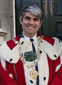
The Dunedin City Council (DCC) governs the Dunedin City territorial authority. It is made up of an elected mayor (currently Aaron Hawkins since 12 October 2019) and fourteen additional councillors elected across three wards, one of whom gets chosen as deputy mayor.
Coat of arms and flag
The city's coat of arms, which were granted in 1947[68] by the Lord Lyon King of Arms, are emblazoned as: Argent above a Fess Dancette Vert, a Castle Triple-Towered sable on a Rock issuing from the Fess, Masoned Argent, with Windows, Vanes and Portcullis Gules. In the base a Three-Masted Lymphad with Sail Furled Azure, Flagged of Scotland, a Ram's Head Affrontee Horned Or between Two Garbs of the last. The supporters are blazoned as: On the Dexter a Scotsman Habited with Philabeg and Plaid of the Clan Cameron, supporting in His Exterior Hand a Cromach; on the Sinister a Maori Chief attired in Korowai, Two Huia Feathers in his hair, an Aurei and a Hei Matau and in His Exterior hand a Taiaha. All Proper.
The castle is taken from the arms of Edinburgh, while the green fess and garb/animals signify regional agriculture and crops. At the base, the lymphad, or ship, alludes to the arrival of Scottish immigrants to the Otago region. The supporters represent the original Māori owners of the land and its Scottish purchasers. All of the elements of the arms are crowned with a mural crown, emblematic of local government. Their motto is: Maiorum Institutis Utendo, or in English, By following in the steps of our forefathers.
The flag of the city of Dunedin is a banner of arms in white and green and featuring the castle, lymphad, ram's head and wheat sheafs as on the coat of arms.
National
Dunedin is covered by two general electorates: Dunedin North and Dunedin South, and one Māori electorate: Te Tai Tonga.
The city in general is a stronghold of the New Zealand Labour Party, having won the Dunedin-based electorate seats continuously since the 1978 election. As of the 2017 general election, both general electorates are held by the party, with David Clark representing Dunedin North and Clare Curran representing Dunedin South. Te Tai Tonga (which covers the entire South Island and part of Wellington in the North Island) is currently also held by the Labour Party and represented by Rino Tirikatene. In addition to electorate MPs, Michael Woodhouse of the National Party is a Dunedin-based list MP.
Media
The major daily newspaper is the Otago Daily Times, which is also the country's oldest daily newspaper and part of the Allied Press group. Weekly and bi-weekly community newspapers include The Star, Taieri Herald, the fortnightly street press POINT, and student magazines Critic (University of Otago) and Gyro (Otago Polytechnic).
The city is served by all major national radio and television stations. The city's main terrestrial television and FM radio transmitter sits atop Mount Cargill, north of the city, while the city's main AM transmitter is located at Highcliff, east of the city centre on the Otago Peninsula. Local radio stations include Radio Dunedin, community station Otago Access Radio (formerly Hills AM, then Toroa Radio), and the university radio station, Radio One. The city has one local television station, Dunedin Television, part of Allied Press.
The city is home to several prominent media-related production companies, notably Natural History New Zealand and Taylormade Media. Dunedin was the location of one of the four television broadcasting installations established in the sixties by the NZBC, operating under the name DNTV2.
The city was once home to the head offices of Radio Otago—now called RadioWorks (part of Mediaworks) and based in Auckland. It was also formerly the home to several now-defunct newspapers, prominent among which were the Otago Witness and the Evening Star.
Education
Secondary
Dunedin is home to 12 secondary schools: eight state and four state-integrated. The oldest secondary school is state-run Otago Boys' High School, founded in 1863. Its sister school, Otago Girls' High School (1871) is the oldest state girls' secondary school in New Zealand, even though it preceded the state education system by six years.
Other state schools include Bayfield High School, Kaikorai Valley College and Logan Park High School. King's High School and Queen's High School are single-sex schools based in St Clair, and Taieri College in Mosgiel. The four state-integrated schools are Columba College, a Presbyterian girls' school; St. Hilda's Collegiate School, an Anglican girls' school; John McGlashan College, a Presbyterian boys' school; and Kavanagh College, a Catholic coeducational school.
Infrastructure and services
Public health and hospitals
Publicly funded primary health and hospital services are provided by the Southern District Health Board (Southern DHB).
Dunedin Public Hospital is the main public hospital in Dunedin. Other hospitals include:
- Mercy Hospital - a private non-profit hospital opened in 1936 and relocated to Maori Hill in 1969[71]
- Wakari Hospital
The Dunedin Public Hospital and the Wakari Hospital, which are closely related, are operated by Southern DHB. Ambulance services are provided by St John New Zealand.
Utilities
Aurora Energy owns and operates the electricity distribution network servicing the city and the Taieri plains, while OtagoNet Joint Venture owns and operates the electricity distribution network in the rural areas north and west of the city. Electricity is primarily supplied from Transpower's national grid at two substations: Halfway Bush and South Dunedin, with part to the OtagoNet network also supplied from Transpower's Naseby substation in central Otago.
Transport
Road
The Dunedin urban area is served by two state highways, with an additional two state highways and one tourist route serving other parts of the district. The main state highway in Dunedin is State Highway 1, which runs in a north to south-west direction through the middle of the city, connecting Dunedin with Invercargill to the south and Timaru and Christchurch to the north. Between The Oval and Mosgiel, State Highway 1 follows the eleven-kilometre Dunedin Southern Motorway. State Highway 88 connects central Dunedin to the city's port facilities at Port Chalmers.
Other State Highways in the city are: State Highway 86 connecting SH 1 at Allanton with Dunedin International Airport, State Highway 87 connecting SH 1 at Kinmont with SH 85 at Kyeburn via Middlemarch, serving the Dunedin city hinterland.
Dunedin is the northeastern terminus of the Southern Scenic Route, a tourist highway connecting Dunedin to Te Anau via The Catlins, Invercargill and Fiordland.

Bus
Buses in Dunedin are organised by the Otago Regional Council. A total of 64 buses operate on 17 weekday routes and 13 weeknight/weekend/holiday routes across the city. Buses are run by two operators, Ritchies Transport with three routes and Go Bus Transport with the remainder. Dunedin City Council-owned operator Citibus was a major player until 2011 when Passenger Transport (New Zealand) purchased Citibus from Dunedin City Holdings, and both companies were subsequently bought by Go Bus.
Rail
Dunedin Railway Station, located east of the Octagon, is the city's main railway station. Once the nation's busiest, decline in rail over the years saw the withdrawal of most services. Suburban services ceased in 1982, and the last regular commercial passenger train to serve Dunedin, The Southerner, was cancelled in February 2002. The Taieri Gorge Railway currently operates tourist-oriented services from the station, the most prominent of which is the Taieri Gorge Limited, a popular and famous train operated daily along the former Otago Central Railway through the scenic Taieri Gorge. Taieri Gorge Railway also operates to Palmerston once weekly. The station is also sometimes visited by excursions organised by other heritage railway societies, and by trains chartered by cruise ships docking at Port Chalmers.
Air

Dunedin International Airport is located 22 km (13.67 mi) southwest of the city, on the Taieri Plains at Momona. The airport operates a single terminal and 1,900-metre (6,200 ft) runway, and is the third-busiest airport in the South Island, after Christchurch and Queenstown. It is primarily used for domestic flights, with regular flights to and from Auckland, Christchurch, Wellington and charter flights to and from Queenstown, Wanaka, and Invercargill, but it also has international flights arriving from and departing to Brisbane year round. In recent years, a decline in international passengers can be attributed to fewer international flights operating direct to the airport.
Sea
A ferry operates between Port Chalmers and Portobello it started in 2018 and is the first since the early 20th century.[72] Occasional calls have been made to revive them, and a non-profit organisation, Otago Ferries Inc., has been set up to examine the logistics of restoring one of the original ferries and again using it for this route.[73]
In 1866, plans were made for a bridge across the Otago Harbour between Port Chalmers and Portobello,[74] but this grand scheme for an 1140-metre structure never eventuated. Plans were also mooted during the 1870s for a canal between the Pacific coast at Tomahawk and Andersons Bay, close to the head of the harbour.[75] This scheme also never came to fruition.
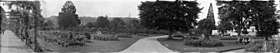
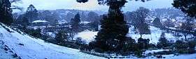
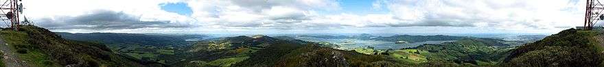
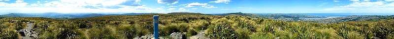
Panoramas


Notable people
Events
Annual events
- January – Whare Flat Folk Festival ends
- February – New Zealand Masters Games (Biennial event)
- February – Otago University Students' Association & Otago Polytechnic Orientation Weeks
- February – Dunedin Summer Festival
- March – Dunedin Fringe Festival
- March/April – iD Dunedin Fashion Week
- May – Capping week (University of Otago) including the Capping Show run by the Otago University Students' Association
- May – International Rally of Otago
- May – Dunedin Writers & Readers Festival
- May – Regent Theatre 24-hour book sale (reputedly the southern hemisphere's largest regularly held second-hand book sale)[76]
- June – Dunedin Midwinter Carnival
- June – St. Clair Polar Plunge
- July – University Reorientation
- July – New Zealand International Science Festival (every second year)
- July – Taste Otago Dunedin Food and Wine Festival
- July – Dunedin International Film Festival
- September – Dunedin City Marathon
- September – Dunedin Beer Festival
- October – Dunedin Arts Festival – every second year (even numbered years)
- October – Rhododendron Week
- December – Samstock Music Festival
- December – Santa Parade
- December – Whare Flat Folk Festival begins
- December – New Year's Eve Party Octagon
Past events
- 1865 – New Zealand Exhibition
- 1889 – New Zealand and South Seas Exhibition (1889)
- 1898 – Otago Jubilee Industrial Exhibition (1898)
- 1925 – New Zealand and South Seas International Exhibition (1925)
Main sights
- Dunedin Railway Station
- Dunedin Town Hall
- Larnach Castle
- Cargill's Castle
- Cadbury World4
- List of historic places in Dunedin
- Olveston
- Speight's Brewery
- University of Otago Registry Building
- University of Otago Clocktower complex
- Regent Theatre
- Fortune Theatre
- Dunedin Public Hospital
- The Octagon
- Orokonui Ecosanctuary
- Royal Albatross Centre
- St. Clair Beach
- Forsyth Barr Stadium
Museums, art galleries, and libraries
Churches
- All Saints' Church
- Church of Jesus Christ of Latter-day Saints
- First Church
- Hanover Street Baptist Church
- Kaikorai Presbyterian Church
- Knox Church
- St. Joseph's Cathedral
- St Michael's Antiochian Orthodox Church
- St. Matthew's Church
- St. Paul's Cathedral
- Trinity Wesleyan Church – now the Fortune Theatre
Parks and gardens
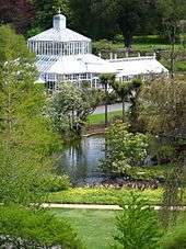
- Botanic Garden
- Dunedin Chinese Garden
- Woodhaugh Gardens
International relations
Sister cities
Dunedin is twinned with several cities throughout the world. These include:


Footnotes
- The description of Auckland, Wellington, Christchurch and Dunedin as the four main centres neatly divides the country geographically into northern and southern halves of each of the two main islands. These centres are thus described in a wide range of fields, from encyclopedias of New Zealand[11] to scientific research institutes,[12] the tourism industry[13] to nationwide organisations[14] and government departments,[15] and from the entertainment industry[16] to newspaper reports.[17]
References
Citations
- "Southern style". Stuff. 19 March 2009. Archived from the original on 23 October 2012. Retrieved 15 March 2011.
- "Supersport's Good Week / Bad Week: An unhappy spectator". The New Zealand Herald. 1 May 2009. Archived from the original on 6 April 2012. Retrieved 18 September 2009.
- Irwin, Geoff; Walrond, Carl (4 March 2009). "When was New Zealand first settled? – The date debate". Te Ara: The Encyclopedia of New Zealand. Archived from the original on 24 May 2010. Retrieved 14 February 2010.
- Dunedin Town Board
- "Mayor Dave Cull". Dunedin City Council. Archived from the original on 23 September 2015. Retrieved 14 February 2015.
- "Subnational Population Estimates: At 30 June 2019". Statistics New Zealand. 22 October 2019. Retrieved 11 January 2020.
- "Dunedin", OxfordDictionaries.com, Oxford University Press, archived from the original on 7 November 2018, retrieved 8 November 2018
- Dunedin: Edinburgh of the south Archived 16 August 2017 at the Wayback Machine, The Scotsman, 18 April 2012
- Malcolm McKinnon (2005). "Otago region — The Otago settlement". Te Ara - the Encyclopedia of New Zealand. Archived from the original on 15 June 2017. Retrieved 13 July 2017.
- "2013 Census Usually Resident Population Counts". Archived from the original on 15 October 2013. Retrieved 15 October 2013.
- David Thorns; Ben Schrader (11 March 2010). "City history and people — Towns to cities". Te Ara - the Encyclopedia of New Zealand. Archived from the original on 19 November 2018. Retrieved 18 November 2018.
- "September 2003". National Institute of Water and Atmospheric Research. 28 February 2007. Archived from the original on 5 January 2010. Retrieved 9 November 2010.
- "Dunedin". Archived from the original on 25 May 2010. Retrieved 9 November 2010.
- "Our history". Plunket Society. Archived from the original on 14 October 2008. Retrieved 13 June 2015.
- "Youth Education Service history". New Zealand Police. Archived from the original on 27 November 2010. Retrieved 9 November 2010.
- Bannister, Matthew. "Flying Nun History 1980-1995". undertheradar.com. Archived from the original on 14 October 2010. Retrieved 9 November 2010.
- Benson, Nigel (29 November 2008). "Dunedin jazz stalwart in full swing". Otago Daily Times. Archived from the original on 17 October 2012. Retrieved 9 November 2010.
- "2013 Census QuickStats about a place: Dunedin City". Statistics New Zealand. Archived from the original on 8 February 2017. Retrieved 7 February 2017.
- "28 cities join the UNESCO Creative Cities Network". Archived from the original on 15 October 2014. Retrieved 4 December 2014.
- Hamel 2001.
- Anderson, Allingham & Smith 1996.
- Anderson 1998.
- Anderson 1983.
- Turton, Hanson "Introductory" in Bathgate 1890
- Entwisle 2005.
- McLintock 1949.
- Begg & Begg 1979.
- Beaglehole 1955–67.
- Entwisle 1998.
- Byrne, T. B. "Wing, Thomas 1810–1888". Dictionary of New Zealand Biography. Retrieved 17 March 2009.
- Somerville, Ross. "Tuckett, Frederick 1807? – 1876". Dictionary of New Zealand Biography. Retrieved 17 March 2009.
- Symcox, Jonathan (28 March 2014). "Royal tour 2014: Kate Middleton and Prince William to visit Dunedin - profile of New Zealand city". Daily Mirror. Archived from the original on 15 June 2014. Retrieved 8 July 2017.
- Campsie, Alison (21 March 2017). "The Scottish origins of New Zealand city Dunedin". The Scotsman. Archived from the original on 2 July 2017. Retrieved 8 July 2017.
- Hocken 1898.
- McDonald 1965.
- Betteridge, Chris (28 July 2004). "Landscapes of Memory – breathing new life into old cemeteries" (PDF). NZ Historic Places Trust. p. 2. Archived from the original (PDF) on 23 November 2004. Retrieved 14 May 2008.
- Notice. Otago Daily Times 21 June 1873 Page 2
- Morrell 1969.
- McLintock 1951.
- Entwisle 1984.
- Collins & Entwisle 1986.
- McCormick 1954.
- Entwisle, Dunn & Collins 1988.
- Dunn 2005.
- McCormick 1959.
- Shuker, Roy (2001). Understanding popular music. Routledge.
- Dunedin City council page
- "Where is England's steepest residential street?". 10 January 2017. Archived from the original on 13 February 2019. Retrieved 22 June 2018 – via www.bbc.co.uk.
- Thread fashion magazine article
- Schaer, Cathrin (3 March 2008). "Rain fails to dampen Dunedin's fashion parade". New Zealand Herald. APN Holdings.
- McNeilly, Hamish (16 July 2019). "A day of ups and downs for the king of Baldwin St". Stuff. Retrieved 16 July 2019.
- Morris, Chris (16 July 2019). "Dunedin loses steepest street title". Otago Daily Times. Archived from the original on 16 July 2019. Retrieved 16 July 2019.
- Morris, Chris (16 July 2019). "Dunedin's Baldwin Street loses steepest world title: Why residents are celebrating". The New Zealand Herald. Archived from the original on 16 July 2019. Retrieved 16 July 2019.
- "Dunedin City". An Encyclopedia of New Zealand. 1966. Archived from the original on 15 September 2016. Retrieved 1 September 2016.
- "Steepest Streets in Dunedin". Dunedin City Council. Archived from the original on 26 May 2003. Retrieved 16 May 2008.
- Dann & Peat 1989.
- Bishop & Hamel 1993.
- Lambert, M., ed. (1988). "Long-term average, 1951–1980". Air New Zealand almanac. Wellington, NZ: New Zealand Press Association. pp. 394–95.
- McLintock, A. H., ed. (1959). "Map 8". A Descriptive Atlas of New Zealand. New Zealand Government Printer.
- "Climate Data and Activities". NIWA. Archived from the original on 10 October 2013. Retrieved 19 October 2013.
- "Statistical area 1 dataset for 2018 Census". Statistics New Zealand. March 2020. Dunedin City (071). 2018 Census place summary: Dunedin City
- "Dunedin Thrilled to be UNESCO City of Literature". Archived from the original on 13 January 2015. Retrieved 4 December 2014.
- "Arai te Uru". ngatitahu.iwi.nz. Ngāi Tahu. Archived from the original on 14 June 2018. Retrieved 19 June 2018.
- "Te Kāhui Māngai directory". tkm.govt.nz. Te Puni Kōkiri. Archived from the original on 22 June 2018. Retrieved 19 June 2018.
- "Māori Maps". maorimaps.com. Te Potiki National Trust. Archived from the original on 27 January 2018. Retrieved 19 June 2018.
- "(101461) Dunedin". Minor Planet Center. Retrieved 20 November 2019.
- "MPC/MPO/MPS Archive". Minor Planet Center. Retrieved 20 November 2019.
- "Coat of Arms of Dunedin City". Dunedin City Council. Archived from the original on 14 June 2017. Retrieved 18 April 2017.
- "Otago University in New Zealand – Beautiful universities around the world". The Daily Telegraph (UK). 16 August 2012. Archived from the original on 11 March 2016. Retrieved 25 March 2016.
- "World's most beautiful universities". Huffington Post (UK). 2012. Archived from the original on 3 April 2016. Retrieved 25 March 2016.
- "Archived copy". Archived from the original on 26 May 2019. Retrieved 26 May 2019.CS1 maint: archived copy as title (link)
- "PORTOBELLO Railway Ferry Company Ltd". Community archive. Archived from the original on 25 May 2010. Retrieved 2 November 2009.
- "Otago Ferries Inc". Archived from the original on 25 May 2010. Retrieved 2 November 2009.
- Hayward 1998, p. 65.
- Hayward 1998, p. 66.
- "NZ's biggest book sale reaches 25-year milestone". Scoop. 9 May 2005. Archived from the original on 16 December 2008. Retrieved 25 July 2009.
- "Sister cities – Edinburgh – Scotland". Dunedin City Council. Archived from the original on 3 June 2010. Retrieved 5 December 2011.
- "Twin and Partner Cities". City of Edinburgh Council. Archived from the original on 14 June 2012. Retrieved 16 January 2009.
- "Sister cities – Otaru – Japan". Dunedin City Council. Archived from the original on 23 September 2015. Retrieved 5 December 2011.
- "Sister cities – Portsmouth – USA". Dunedin City Council. Archived from the original on 23 September 2015. Retrieved 5 December 2011.
- "Sister cities – Shanghai – China". Dunedin City Council. Archived from the original on 2 August 2012. Retrieved 5 December 2011.
General sources
- Anderson, Atholl (1983), When All the Moa-Ovens Grew Cold: nine centuries of changing fortune for the southern Maori, Dunedin, NZ: Otago Heritage BooksCS1 maint: ref=harv (link)
- Anderson, Atholl (1998), The Welcome of Strangers: an ethnohistory of southern Maori A.D. 1650–1850, Dunedin, NZ: University of Otago Press with Dunedin City Council, ISBN 1-877133-41-8CS1 maint: ref=harv (link)
- Anderson, Atholl; Allingham, Brian; Smith, Ian W G (1996), Shag River Mouth: the archaeology of an early southern Maori village, Canberra, Australia: Australian National University, OCLC 34751263, ISBN 0-7315-0342-1CS1 maint: ref=harv (link)
- Bathgate, Alexander, ed. (1890), Picturesque Dunedin, Dunedin, NZ: Mills, Dick & Co., OCLC 154535977CS1 maint: ref=harv (link)
- Beaglehole, J C, ed. (1955–67), The Journals of Captain James Cook, London, UK: The Hakluyt SocietyCS1 maint: ref=harv (link)
- Begg, A. Charles; Begg, Neil Colquhoun (1979), The world of John Boultbee: including an account of sealing in Australia and New Zealand, Christchurch, NZ: Whitcoulls, ISBN 0-7233-0604-4CS1 maint: ref=harv (link)
- Bishop, Graham; Hamel, Antony (1993), From sea to silver peaks, Dunedin: John McIndoe, ISBN 0-86868-149-0CS1 maint: ref=harv (link)
- Collins, Roger; Entwisle, Peter (1986), Pavilioned in Splendour, George O'Brien's Vision of Colonial New Zealand, Dunedin, NZ: Dunedin Public Art Gallery, ISBN 0-9597758-1-1CS1 maint: ref=harv (link)
- Dann, Christine; Peat, Neville (1989), Dunedin, North and South Otago, Wellington: GP Books, ISBN 0-477-01438-0CS1 maint: ref=harv (link)
- Dunn, Michael (2005), Nerli an Italian Painter in the South Pacific, Auckland University Press., ISBN 1-86940-335-5CS1 maint: ref=harv (link)
- Entwisle, Peter (1984), William Mathew Hodgkins & his Circle, Dunedin, NZ: Dunedin Public Art Gallery, ISBN 0-473-00263-9CS1 maint: ref=harv (link)
- Entwisle, Peter (1998), Behold the Moon, the European Occupation of the Dunedin District 1770–1848, Dunedin, NZ: Port Daniel Press., ISBN 0-473-05591-0CS1 maint: ref=harv (link)
- Entwisle, Peter (2005), Taka, a Vignette Life of William Tucker 1784–1817, Dunedin, NZ: Port Daniel Press., ISBN 0-473-10098-3CS1 maint: ref=harv (link)
- Entwisle, Peter; Dunn, Michael; Collins, Roger (1988), Nerli An Exhibition of Paintings & Drawings, Dunedin, NZ: Dunedin Public Art Gallery, ISBN 0-9597758-4-6CS1 maint: ref=harv (link)
- Hamel, J (2001), The Archaeology of Otago, Wellington, NZ: Department of Conservation, ISBN 0-478-22016-2CS1 maint: ref=harv (link)
- Hayward, Paul (1998), Intriguing Dunedin Street Walks, Dunedin, NZ: Express Office ServicesCS1 maint: ref=harv (link)
- Hocken, Thomas Moreland (1898), Contributions to the Early History of New Zealand (Settlement of Otago), London, UK: Sampson Low, Marston and Company, OCLC 3804372CS1 maint: ref=harv (link)
- McCormick, E H (1954), The Expatriate, a Study of Frances Hodgkins, Wellington, NZ: New Zealand University Press., OCLC 6276263CS1 maint: ref=harv (link)
- McCormick, E H (1959), The Inland Eye, a Sketch in Visual Autobiography, Auckland, NZ: Auckland Gallery Associates, OCLC 11777388CS1 maint: ref=harv (link)
- McDonald, K C (1965), City of Dunedin, a Century of Civic Enterprise, Dunedin, NZ: Dunedin City Corporation, OCLC 10563910CS1 maint: ref=harv (link)
- McLintock, A H (1949), The History of Otago; the origins and growth of a Wakefield class settlement, Dunedin, NZ: Otago Centennial Historical Publications, OCLC 154645934CS1 maint: ref=harv (link)
- McLintock, A H (1951), The Port of Otago, Dunedin, NZ: Otago Harbour BoardCS1 maint: ref=harv (link)
- Morrell, W P (1969), The University of Otago, a Centennial History, Dunedin, NZ: University of Otago Press., OCLC 71676CS1 maint: ref=harv (link)
Further reading
- Fox-Davies, A. C. (1909). A Complete Guide to Heraldry.
- Herd, J. & Griffiths, G. J. (1980). Discovering Dunedin. Dunedin: John McIndoe. ISBN 0-86868-030-3.
- McCoy, E. & Blackman, J. (1968). Victorian City of New Zealand: Photographs of the Earlier Buildings of Dunedin. Dunedin: John McIndoe. OCLC 16481. (E. McCoy was New Zealand architect.)
- McFarlane, S. (1970). Dunedin, Portrait of a City. Whitcombe & Tombs. ISBN 0-7233-0171-9.
- Smallfield, J. & Heenan, B. (2006). Above the belt: A history of the suburb of Maori Hill. Dunedin: Maori Hill History Charitable Trust. ISBN 1-877139-98-X.
External links
| Wikimedia Commons has media related to Dunedin. |
| Wikivoyage has a travel guide for Dunedin. |
Neighbouring cities, towns and places | ||||||||||
|---|---|---|---|---|---|---|---|---|---|---|
| ||||||||||