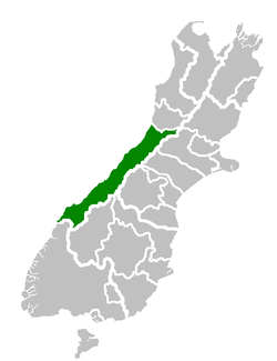
Westland District
Westland District is a territorial authority on the West Coast of New Zealand's South Island. It is administered by the Westland District Council. The district's population is 8,960 (June 2019).[1]
Westland District | |
|---|---|
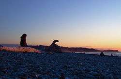 Gillespie Beach, Westland | |
 | |
| Country | New Zealand |
| Region | West Coast |
| District | Westland District Council |
| Wards | Hokitika Northern Southern |
| Seat | Hokitika |
| Government | |
| • Mayor | Bruce Smith |
| Area | |
| • Total | 11,880.19 km2 (4,586.97 sq mi) |
| Population (June 2019)[1] | |
| • Total | 8,960 |
| • Density | 0.75/km2 (2.0/sq mi) |
| Time zone | UTC+12 (NZST) |
| • Summer (DST) | UTC+13 (NZDT) |
| Postcode(s) | |
| Area code(s) | 03 |
| Website | westland.govt.nz |
Government
The Westland District is governed by an elected Council, headed by an elected Mayor. The Mayor is elected at large. The current Mayor is Bruce Smith. Councillors are elected to represent multi-member wards. Three councillors are elected for the Northern Ward, three for the Southern Ward, and four for the town of Hokitika.
The District is one of three included within the West Coast Region.
Geography
The District consists of a long thin strip of land between the crest of the Southern Alps and the Tasman Sea. The low-lying areas near the coast are a mixture of pastoral farmland and temperate rainforest. Westland temperate rainforests contain many conifers and receives high rates of precipitation due to orographic lifting caused by the Southern Alps. The eastern part of the District is steep and mountainous. Many small rivers flow down from the mountains. The southern part of the District notably contains the Franz Josef and Fox glaciers.
Westland is one of the most sparsely populated parts of the country, with an area of 11,880.19 square kilometres and a population density of 0.75 people per square kilometre. Approximately 34.5% of the population (3,090) lives in Hokitika. The remaining population lives in small villages such as Ross, Franz Josef and Haast, or in rural areas.
In the north, the Taramakau River, the largest river in the district, forms the boundary with the Grey District. The crest of the Southern Alps marks the eastern boundary. A small southern boundary lies between Westland proper and Fiordland, which lies within the Southland District. This boundary cannot be crossed by road.
Demographics
| Historical population | ||
|---|---|---|
| Year | Pop. | ±% p.a. |
| 2006 | 8,403 | — |
| 2013 | 8,304 | −0.17% |
| 2018 | 8,640 | +0.80% |
| Source: [2] | ||
Westland District had a population of 8,640 at the 2018 New Zealand census, an increase of 336 people (4.0%) since the 2013 census, and an increase of 237 people (2.8%) since the 2006 census. There were 3,747 households. There were 4,356 males and 4,287 females, giving a sex ratio of 1.02 males per female. Of the total population, 1,449 people (16.8%) were aged up to 15 years, 1,446 (16.7%) were 15 to 29, 4,212 (48.8%) were 30 to 64, and 1,536 (17.8%) were 65 or older. Figures may not add up to the total due to rounding.
Ethnicities were 86.5% European/Pākehā, 14.4% Māori, 2.0% Pacific peoples, 5.2% Asian, and 3.0% other ethnicities. People may identify with more than one ethnicity.
The percentage of people born overseas was 16.3, compared with 27.1% nationally.
Although some people objected to giving their religion, 51.4% had no religion, 36.7% were Christian, and 3.7% had other religions.
Of those at least 15 years old, 1,056 (14.7%) people had a bachelor or higher degree, and 1,656 (23.0%) people had no formal qualifications. The median income was $29,600. The employment status of those at least 15 was that 3,975 (55.3%) people were employed full-time, 1,137 (15.8%) were part-time, and 153 (2.1%) were unemployed.[2]
Economy
In the early years of settlement in Westland, gold was a major commodity, bringing prospectors flocking into the area. After the gold ran out, those who remained turned to pastoral farming. (Unlike the more northern parts of the West Coast, Westland has not developed coal mining.) In recent years, tourism has become more important, with drawcards such as the glaciers, and events such as the Hokitika Wildfoods Festival.
History
Westland was originally a part of Canterbury Province, administered from Christchurch in the East coast. The booming population as a result of the gold rush, together with the difficulty of travel and communication across the Southern Alps, led first to the creation of a special Westland County, then the formal separation of Westland from Canterbury to form the short-lived Westland Province (1873–1876). Westland Province also included what is now the southern portion of Grey District with the provincial boundary at the Grey and Arnold rivers. Greymouth proper was in Westland Province, Cobden, on the north bank of the Grey River, was in Nelson Province .
After the abolition of the provinces in 1876, a new Westland County was created with roughly the same borders as the old Province. About this time, the population relative to the rest of the country began to decline, as the easily accessible gold soon ran out and the conditions were not ideal for farming. Local government changes saw the hinterland of Greymouth on both sides of the Grey River transformed into Greymouth Borough and Grey County and subsequently into Grey District, which includes portions of both historical provinces.
However Westland, as a unit of government, emerged largely intact from the local government reforms of the 1980s and 1990s, merely changing from a County to a District and incorporating the Borough of Hokitika.
Recently the population has begun to grow more quickly due to "lifestyle" residents moving into the District.
Populated places
Westland District consists of the following towns, localities, settlements and communities:
|
|
- Notes: bold - main town; bold & italics - minor town; normal text - locality; italics - minor locality
References
- "Subnational Population Estimates: At 30 June 2019". Statistics New Zealand. 22 October 2019. Retrieved 11 January 2020.
- "Statistical area 1 dataset for 2018 Census". Statistics New Zealand. March 2020. Westland District (057). 2018 Census place summary: Westland District