Waikato River
The Waikato River is the longest river in New Zealand, running for 425 kilometres (264 mi) through the North Island. It rises in the eastern slopes of Mount Ruapehu, joining the Tongariro River system and flowing through Lake Taupo, New Zealand's largest lake. It then drains Taupo at the lake's northeastern edge, creates the Huka Falls, and flows northwest through the Waikato Plains. It empties into the Tasman Sea south of Auckland, at Port Waikato. It gives its name to the Waikato region that surrounds the Waikato Plains. The present course of the river was largely formed about 17,000 years ago. Contributing factors were climate warming, forest being reestablished in the river headwaters and the deepening, rather than widening, of the existing river channel. The channel was gradually eroded as far up river as Piarere, leaving the old Hinuera channel through the Hinuera Gap high and dry.[2] The remains of the old river path can be clearly seen at Hinuera where the cliffs mark the ancient river edges. The river's main tributary is the Waipa River, which has its confluence with the Waikato at Ngāruawāhia.
| Waikato River | |
|---|---|
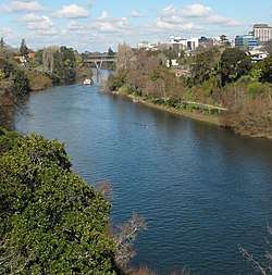 Waikato River passing through Hamilton | |
 The Waikato River (interactive map) | |
| Location | |
| Country | New Zealand |
| Physical characteristics | |
| Source | |
| ⁃ location | Lake Taupo |
| Mouth | |
⁃ location | Port Waikato |
⁃ elevation | 0.0 metres (0 ft) |
| Length | 425 kilometres (264 mi) |
| Basin size | 13,701 km2 (5,290 sq mi) to Mercer[1] |
The name Waikato comes from the Māori language and translates as flowing water.[3] The Waikato River has spiritual meaning for various local Māori tribes, including the large Tainui, who regard it as a source of their mana, or pride. The widely respected marae of Tūrangawaewae is close to its banks at Ngāruawāhia.
For many years Tainui tribe have sought to re-establish their links to the river after the New Zealand Wars (see Invasion of the Waikato) and the subsequent confiscations of the 1860s, and are continuing negotiations with the New Zealand government. The Tainui iwi was advised not to bring a case for the river before the Waitangi Tribunal as they would not win. An out of court settlement was arranged and the deed of settlement signed by the Crown and Waikato-Tainui in August 2008 settled the raupatu claim to the Waikato River, although other claims for land blocks and harbours are still outstanding. Waikato-Tainui now have joint management of the river with the Waikato Regional Council.
Origin
The ancestral Waikato River flowed from an ancient lake (Lake Huka) in the centre of the North Island through deep gorges of welded ignimbrite and rhyolite, northward through the Hinuera Valley and Hauraki Basin into the Thames Estuary. It is possible that the river flowed through the Waikato Basin about a million years ago before returning to its Hinuera course. After the huge Oruanui eruption 27,000 years ago ignimbrite was showered all over the North Island to a thickness of 200 metres (660 ft).[4] A new lake was formed - Lake Taupo. The water built up until a new outlet was forced 120 metres (390 ft) above the present level near Waihora Bay. Over the next few thousand years the bed of the river was raised by large amounts of eruption debris. Then the original blocked entry suddenly gave way; the lake level fell 75 metres (246 ft) as about 80 cubic kilometres (19 cu mi) of water and debris poured out in a catastrophic breakthrough flood causing the river to change course near Piarere. The Hinuera Gap and Waitoa River are evidence of the river's former course. The water level dropped quickly and the river stayed in this new course through the Maungatautari gorge and Hamilton Basin. Deposits show that the Waikato River was already in the Waikato Basin 21,800 years ago.[5]
Course


The river starts in the form of many small streams on the eastern slopes of Mount Ruapehu. The Mangatoetoenui Glacier (once also called the Waikato Glacier) is one of the principal sources.[6] The southernmost tributary is called the Upper Waikato Stream. The Waipakihi River joins the Waikato from the Kaimanawa Mountains to the west. From the point where the river meets the Waihohonu Stream, down to Lake Taupo, it has been formally named the Tongariro River since 1945.[6]
The Poutu Stream joins from Lake Rotoaira to the east, as a tributary of the Tongariro,[7] which flows northward, with State Highway 1 in parallel, through the town of Turangi, and into the southern side of Lake Taupo.[8][9] Extensive engineering of lakes, tunnels and canals are used to generate hydroelectric power in the Tongariro Power Scheme.[10]
The Waikato River flows out of Lake Taupo at the town of Taupo in Tapuaeharuru Bay at the northeast end of the lake. It flows northeast past the town, alongside State Highway 1, to the Huka Falls. State Highway 5 runs more or less parallel to the river as it flows further northeast. About 40 kilometres (25 mi) from the lake, the river flows west and into the southern end of Lake Ohakuri. It exits from the northwest end of that lake and flows west through the small Lake Atiamuri and into the long east–west oriented Lake Whakamaru, with State Highway 30 following its course. It passes northwest through Lake Maraetai and Lake Waipapa, where it is joined by the Waipapa River, then north through Lake Arapuni and into Lake Karapiro. Pokaiwhenua Stream joins the river in Lake Karapiro.[11][12] Nine hydroelectric power stations at eight dams extract energy from the river between Taupo and Karapiro. All the lakes in this stretch of the river (apart from Lake Taupo) are artificial.[13]
The river leaves the Volcanic Plateau at Karapiro, where it emerges from the Maungatautari Gorge, and flows northwest into the Waikato Basin, flowing through the towns of Cambridge, Hamilton, and Ngāruawāhia.[14] It is joined by its largest tributary, the Waipa River, at Ngāruawāhia. It then flows north through the Taupiri Gorge[15] to enter the lower Waikato region.[3] Further north is Huntly and then Meremere, where the Whangamarino and Maramarua Rivers join it. From Mercer, where the Mangatawhiri River joins it, the Waikato flows west and southwest. Just before its mouth at Port Waikato, the Araroa River joins from the north.[16] Numerous small islands lie in the long, thin delta of the river as it passes through low-lying swampy land between Meremere and the coast, the largest of which is Motutieke Island.
There are also over 40 islands between Ngāruawāhia and Tuakau,[17] depending on the level of the river. Maurea Islands, just south of Rangiriri were subject to a restoration trial to test comparative weed treatments, the main weeds being alder and yellow flag iris.[18]
In prehistoric times, the Waikato's course has occasionally shifted to flow north through the Hinuera Gap into the Firth of Thames and from there into the Hauraki Gulf. The most recent occasion this is known to have occurred ended some 20,000 years ago, although it is possible that it also flowed north more recently, until about 1800 years ago. A remnant of this former course can be seen as a spur on Lake Karapiro to the south of the settlement of Piarere.[19] The river's current course is largely the result of the massive Hatepe (Taupo) volcanic eruption of 180 AD.[20]
The mean discharge of the Waikato River is 340 cubic metres per second (12,000 cu ft/s), with the highest flows typically occurring in July and August. Specific mean annual floods are low (60–70 L s-1 km-2), and the frequency of events with greater than 3 times the median flow is 0.4 events / year, due to flow regulation and groundwater storage in pumice.[21]
Human use
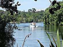
As well as being a water and recreation resource, the river was historically a critical communications and transport link for the communities along it.[22] It took about 3 days to paddle a waka from Waiuku to the Cambridge/Te Awamutu area.[23] Taupo, Mangakino, Cambridge, Hamilton, Horotiu, Ngāruawāhia, Huntly, Hampton Downs, Meremere, Waiuku and Port Waikato are on or close to it. The Waikato River in Hamilton is frequently used by rowers, kayakers and powered pleasure craft. Water-skiers and jet skis have zones outside the city limits where they can be used.
The river was of military importance in the land wars between New Zealand settler and Kingitanga forces during 1863–64 and significant battles were fought. Three shallow draft gunboats were designed in New Zealand and built in Sydney in kitset form. In addition locally sourced barges were rebuilt with steel plating to carry troops and supplies. In support of these invasions, New Zealand developed its first "navy", the Waikato Flotilla, run by an Australian Francis Cadell who was recognised for his spendid service by the presentation by the New Zealand government of a gold watch and diamonds. A cemetery containing the graves of the British military dead can be found at Rangiriri opposite the hotel, shops and cafe.
Electricity generation

The Waikato's first hydro-electric power station was the Horahora Power Station, now located under the Horahora bridge deep beneath the surface of Lake Karapiro. Horahora was built to supply electricity for the Martha gold mines at Waihi.[24]
The river has a series of eight dams and nine hydro-electric power stations that generate electricity for the national grid. These were constructed between 1929 and 1971 to meet growing demand for electricity.
The power scheme begins at Lake Taupo, which has control gates to regulate the flow of water into the river. Once released through the gates it takes over 18 hours for the water to flow to the last power station at Karapiro.[25] On its journey downstream it passes through power stations at Aratiatia, Ohakuri, Atiamuri, Whakamaru, Maraetai, Waipapa, Arapuni and Karapiro.
Approximately 4000 gigawatt hours (GWh) of electricity is generated annually by the scheme, which is around 13% of New Zealand's total electrical generating capacity.
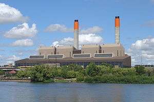
The river also provides cooling water for the coal/natural gas fired thermal power station at Huntly. The power station uses river water as a cooling medium for the old steam units, which means that large quantities of warm water is returned to the river. To limit environmental impacts, conditions are imposed by its resource consent, specifying the quantity of water that can be removed by the station along with the maximum temperature of the water when returned to the river, 25 °C (77 °F). These conditions mean that output of the older steam units can be restricted, especially on very hot summer days. In 2006, a cooling tower was installed. This allows one 250 MW unit to run at full load even during such times.[26]
.jpg)
Recreation
The lower Waikato is popular amongst duck shooters.[27]
Boating
The Waikato is renowned among whitewater kayaking enthusiasts, specifically for the Full James rapid located north of Taupo. The Full James was the site of the 1999 World Whitewater Championships, as well as the pre-World event the year before.[28]
Lake Karapiro (an artificial lake) is regarded as one of New Zealand's best rowing venues. The World Rowing Championships in 1978 and 2010, and the 1950 British Empire Games were hosted at Karapiro.[29]
The section of the river that flows through Hamilton has the most diverse river traffic with many schools and clubs using rowing skiffs. Rowing races are also held on the river. Jet skis are confined to the city margins because of their noise. Power boats regularly use the river, including manufacturers and boating shops testing and demonstrating boats, especially in summer. In addition there are numerous kayaks and a few waka.
There are council boat ramps, run by Waikato District, Hamilton City, South Waikato District and Taupo District, at Port Waikato Rd; Hoods Landing Rd, Otaua; Elbow Rd, Aka aka; River Rd, Tuakau; Riverbank Rd, Mercer; Churchill East Rd, Rangiriri; Ohinewai Landing Rd; Boatie Reserve SH1, Parry St and Riverview Rd, Huntly; SH1 Taupiri; Waikato Esplanade, Ngāruawāhia;[30] Farm and Braithwaite Parks, Pukete; Swarbricks Landing, Hamilton Pde, Pine Beach, Ferrybank, Memorial Park, Roose Commerce Park, Hayes Paddock, Hamilton Gardens;[31] Narrows Lane, Tamahere;[30] Karapiro (6 ramps); Arapuni (4); Maraetai;[32] Whakamaru (3);[33] Ohakuri[32] and Mangakino.[34]
Public cruises
A ferry service along part of its length was for years conducted by Caesar Roose,[35] several of whose descendants still live beside it. He brought the 1894[36] 400-passenger steamer, Manuwai, from the Whanganui in 1920.[37] In 1924 a Cambridge to Port Waikato excursion was being run 2 or 3 times a year, taking 12 to 14 hours downstream and a few hours longer upstream.[38] Manuwai sank at her moorings in 1938, but was taken to Mercer for repair in 1939,[39] where she was converted to a barge.[40] Several of the old steamers remain under, or beside the river,[41] including the Manuwai,[42] Rawhiti (built 1925)[43] and Freetrader on the west bank just south of Mercer.[44]
To improve navigation, rocks in the Narrows[45] at Tamahere were removed in 1919.[46]
Public cruises operate from Aratiatia to Huka Falls,[47] across the river to Orakei Korako,[48] from Hamilton Gardens to Mystery Creek and Fairfield Bridge[49] and, since 2009,[50] from Tuakau to Port Waikato.[51]
Cycle and walk trails
Three trails follow parts of the river.
Boosted by New Zealand Cycle Trail funding, the Waikato River Trails, a 100-kilometre (62 mi) series of connected river cycling trails in the South Waikato.[52] The River Trail has five sections, open to both walkers or bikes, between Lake Karapiro and Aratiatia. It opened in 2011.[53]
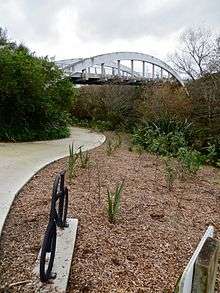
Te Awa River Ride follows over 50 km (31 mi) of the river from Horahora, near the end of the Waikato River Trails, via Cambridge and Hamilton to Ngāruawāhia. Completion was planned for 2017,[54] but the Cambridge-Hamilton section opening is now expected in 2021.[55] North of AFFCO at Horotiu,[56] the route includes the second longest cycle bridge in the country (after the Timber Trail), a 140 m (150 yd) long cable network arch bridge,[57] budgeted to cost $2.6m and to open in August,[58] but opened in November 2017.[59] The section from the Avantidrome through St Peter's School of Cambridge and Tamahere is being constructed in 2019/2020, including an underpass at SH21 to Tamahere Park.[60]
Te Araroa Trail (the river walkway linking the far north with the far south of the country) follows the Waikato for most of its 80 kilometres (50 mi) between Mercer and Hamilton.[61]
Ecology
Species
The Waikato River and its hydro lakes are home to at least 19 types of native fish and 10 types of introduced fish.[62] The introduced species include rainbow and brown trout providing what has been called "the finest fly-fishing in the world".[63] Other introduced species, like the carp and mosquitofish, have become major pests.
Environmental issues
The large catchment area of the Waikato River is highly fertile farmland, so intensive agriculture is present. Due to the agricultural activity within the catchment significant agricultural pollution is leached into groundwater and contained in the runoff. The mismanagement of nitrogen fertilizer and effluent spreading practices in dairy farming is seen as the major causes of this pollution. Since 2000 Environment Waikato has joined with conservation minded farmers to bring about more efficient and scientific use of fertilizers.
The removal of the native vegetation throughout the catchment to accommodate the increasing demand for farmland has contributed to the silting-up of the river with loose soils from eroded farmland, although most of the silting is due to the construction of the many hydrodams. In its pre-1930s wild state, the silt was flushed from the river every winter by flood surges. The remnants of these can be seen in the silt channels carved out of what is now St Andrews golf course, adjacent to the river in Hamilton.
Arsenic is also a major problem and the concentration reaches 0.035 grams of arsenic per cubic metre in places,[64] greatly exceeding the WHO provisional guideline of 0.01 grams of arsenic per cubic metre.[65] The majority of arsenic in the Waikato River comes from the Wairakei Geothermal Power Station. The amount of arsenic gradually declines as the river flows northwards and is at its lowest at the Waikato River Heads.[66]
Since 2002, around 75 million litres (20,000,000 US gal) of water a day has been drawn from the river at Tuakau, treated and pumped along a 38-kilometre (24 mi) pipe north to Auckland, where it is mixed with local water.[67] This met 8% of Auckland's water needs in 2010/11.[68] In December 2012 capacity was increased to 125 million litres (33,000,000 US gal), and in 2013 work started to increase it to 150 million litres (40,000,000 US gal).[69] The treatment plant meets New Zealand's 2000 drinking water standards according to Water Care NZ. This is equal to or better than the A standard for Auckland's other water supplies.
Slightly-modified human wastes are pumped into the river downriver of several towns. Hamilton city has one of the most modern water treatment systems in the world following a 2003 report by GHB water consultants. In 2007 $22 million was spent upgrading the existing intake station south of the city at Riverlea. This will meet the cities demand until 2016. Waste water in its untreated state is 99.9% water and 0.1% other matter. A series of sophisticated machines produce clean water of a high standard getting rid of bad tastes odours and toxins to meet the upgraded NZ water standards. The Pukete 2 project which started in 2002 will upgrade the plant in a series of stages costing $24 million.
A further issue is industrial and metropolitan waste from early-established landfills and waste-emitting factories on the banks of the river. These include an unlined waste dump at Horotiu, just downriver from Hamilton, whose leachates include persistent organic pollutants such as dieldrin in quantities toxic to freshwater marine life. The 2002 GHD report saw new regulations put in place to make industries comply with a new bylaw which stops hazardous substances entering the water system at all according to the HCC website. In 2002 dead eels were found in a tributary of the river when a container of pesticides and other chemicals was apparently illegally dumped. The chemicals were diluted when they entered the much bigger Waikato River. The harmful effect was temporary.
References
- "Environment". Environment Waikato. Retrieved 28 May 2010.
- The Wandering River . Landforms and geological history of the Hamilton Basin. P 36-37. John McCaw. Geoscience Society of NZ Handbook No 16. 2011. Graphic Press . Levin. NZ.
- "Waikato River". An Encyclopaedia of New Zealand. 1966.
- Wilson, C J N (December 2001). "The 26.5 ka Oruanui eruption, New Zealand: an introduction and overview". Journal of Volcanology and Geothermal Research. 112 (1): 113–174. doi:10.1016/S0377-0273(01)00239-6.
- The Wandering River. John McCaw. Geoscience Society of NZ.p19. Graphic Print and Packaging. Levin. 2011.
- Miles, Sue (1984). The River: The Story of the Waikato. Photographs by Geoff Moon. Heinemann. p. 1. ISBN 978-0-86863-418-0.
- "Poutu Stream, Waikato – NZ Topo Map". NZ Topo Map. Retrieved 13 April 2018.
- Peter Dowling (editor) (2004). Reed New Zealand Atlas. Reed Books. pp. map 38. ISBN 978-0-7900-0952-0.CS1 maint: extra text: authors list (link)
- Roger Smith, GeographX (2005). The Geographic Atlas of New Zealand. Robbie Burton. pp. map 89. ISBN 978-1-877333-20-0.
- "Tongariro Power Scheme". Genesis Energy Limited. Retrieved 19 October 2009.
- Reed New Zealand Atlas, 2004, maps 28–29, 19
- The Geographic Atlas of New Zealand, 2005, maps 78, 66–68, 56
- Miles, 1984, p 62
- Miles, 1984, p 66, 69 & unpaginated intro.
- "South Auckland Land District". Encyclopaedia of New Zealand (1966).
- Reed New Zealand Atlas, 2004, maps 14, 18–19
- "Manutahi Island, Waikato". NZ Topo Map. Retrieved 3 November 2016.
- "Restoration of Maurea Island, Waikato River: Year 2 and final report WRA12-054 and WCEET 2013–19" (PDF). NIWA. Waikato River Authority. June 2015.
- NZ Topomap – Piarere
- "Waikato River". Waikato explorer. Retrieved 13 October 2016.
- Duncan, M.; Woods, R. (2004). Flow regimes. In: Harding, J.S.; Mosley, M.P.; Pearson, C.P.; Sorrell, B.K. (eds). Freshwaters of New Zealand, pp. 7.1–7.14. New Zealand Hydrological Society and New Zealand Limnological Society, Christchurch.
- "National Highway". The New Zealand Herald. 15 March 1918. p. 6. Retrieved 6 June 2016.
- "Chapter IV — The Golden Age Before the War. | NZETC". nzetc.victoria.ac.nz. Retrieved 24 April 2017.
- New Zealand Historical Atlas – McKinnon, Malcolm (Editor); David Bateman, 1997, Plate 88
- "Mighty River Power Generation: About Us: Taupo". Mighty River Power. Retrieved 27 May 2010.
- 2013–2014 Huntly Power Station Environmental Report (PDF), Genesis Energy, 24 November 2014
- "Hunting Locations". Fish & Game. Retrieved 19 February 2018.
- "Battling the white dragon". New Zealand Geographic. Retrieved 19 February 2018.
- "Rowing". nzhistory.govt.nz. Retrieved 19 February 2018.
- "Agenda for a meeting of the Raglan Community Board" (PDF). 13 February 2018. p. 69.
- "Council open agenda" (PDF). Hamilton City Council. 13 November 2012. p. 66.
- "Navigation Safety Bylaw" (PDF). Waikato Regional Council. 2013.
- "Rural Reserves Management Plan – South Waikato District Council". www.southwaikato.govt.nz. Retrieved 27 February 2018.
- "Parks and Reserves – Taupo District Council". www.taupodc.govt.nz. Retrieved 27 February 2018.
- "Roose, Caesar 1886 – 1967". Dictionary of New Zealand Biography. New Zealand Ministry for Culture and Heritage. Retrieved 27 November 2010.
- "Our River Tourist Traffic". The Wanganui Herald. 17 September 1894. p. 2. Retrieved 19 February 2018.
- "Waikato Tourist Steamer". Waikato Times. 15 June 1920. p. 5. Retrieved 19 February 2018.
- "Scenic River Trip". The New Zealand Herald. 19 February 1925. p. 9.
- "Craft Refloated". New Zealand Herald. 1939. p. 10. Retrieved 19 February 2018.
- "Waikato – the royal river". New Zealand Geographic. Retrieved 19 February 2018.
- "Waikato's Steamers – Relics of the past". The New Zealand Herald. 1 April 1932. Retrieved 23 October 2016.
- "Bates, Arthur P :Photograph of the wreck of the 'Manuwai'". natlib.govt.nz. 1 January 1985. Retrieved 19 February 2018.
- "WAIKATO RIVER BOAT. (New Zealand Herald, 1925-10-31)". paperspast.natlib.govt.nz. National Library of New Zealand. Retrieved 24 October 2016.
- "Waikato River Commercial Shipping". New Zealand Ship and Marine Society. Retrieved 23 October 2016.
- "WONDROUS WAIKATO (Waikato Times, 1918-03-16)". paperspast.natlib.govt.nz. National Library of New Zealand. Retrieved 15 January 2017.
- "WAIKATO RIVER LEAGUE (Waikato Times, 1919-07-10)". paperspast.natlib.govt.nz. National Library of New Zealand. Retrieved 15 January 2017.
- "Huka Falls Taupo | River Cruise Information". www.hukafallscruise.co.nz. Retrieved 19 February 2018.
- "Orakei Korako Geothermal Attraction". www.orakeikorako.co.nz. Retrieved 19 February 2018.
- "Waikato River Cruise | Hamilton Gardens". waikatoexplorer.co.nz. Retrieved 19 February 2018.
- "Last of the Waikato river boats". Stuff. Retrieved 19 February 2018.
- "Houseboat Holidays :: Overnight cruises". houseboatholidays.co.nz. Retrieved 19 February 2018.
- "PM turns first sod on cycleway project". The New Zealand Herald. Newstalk ZB. 10 November 2009. Retrieved 30 November 2011.
- "Time to pedal new Waikato tourist attraction". Stuff. Retrieved 19 February 2018.
- "Our Route & Maps – Te Awa". Retrieved 15 September 2016.
- "Regional Transport Committee Agenda" (PDF). 5 March 2018.
- "Bridge to provide missing link for cyclists". Stuff. Retrieved 15 September 2016.
- "Iconic cycle bridge to call Waikato home" (PDF). Link – Waikato District news. August–September 2016.
- "Agenda for a meeting of the Infrastructure Committee" (PDF). Waikato District Council. 27 June 2017. p. 66.
- "Over 5,000 New Zealanders take part in the Aotearoa mini Bike Challenge". nzta-cycling.cmail19.com. Retrieved 3 November 2017.
- "Underpass set for Airport Rd". Tamahere Forum. 31 October 2019. Retrieved 16 February 2020.
- Te Araroa map
- "What lives in the Waikato River" Environment Waikato
- "A Trip down the Waikato River". www.babyboomersguide.co.nz. Retrieved 9 February 2010.
- "How clean is the Waikato River?". Environment Waikato. Retrieved 9 February 2010.
- Guidelines for drinking water quality, Vol. 1, 3rd ed. – World Health Organization, (2006)
- "Changes in arsenic". Environment Waikato. Retrieved 22 September 2009.
- Orsman, Bernard (19 June 2002). "Waikato water all clear for Auckland". The New Zealand Herald. Retrieved 22 February 2013.
- "Waikato River water". Watercare. Retrieved 14 May 2013.
- Thompson, Wayne (14 May 2013). "Water, water everywhere: How it nourishes Auckland". The New Zealand Herald. Retrieved 14 May 2013.