Shire of Yarriambiack
| Shire of Yarriambiack Victoria | |||||||||||||||
|---|---|---|---|---|---|---|---|---|---|---|---|---|---|---|---|
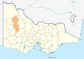 Location in Victoria | |||||||||||||||
| Population | 6,674 (2016 census)[1] | ||||||||||||||
| • Density | 0.93238/km2 (2.4149/sq mi) | ||||||||||||||
| Established | 1995 | ||||||||||||||
| Gazetted | 20 January 1995[2] | ||||||||||||||
| Area | 7,158 km2 (2,763.7 sq mi) | ||||||||||||||
| Mayor | Cr Graeme Massey | ||||||||||||||
| Council seat | Warracknabeal | ||||||||||||||
| Region | Western Victoria | ||||||||||||||
| State electorate(s) | |||||||||||||||
| Federal Division(s) | Mallee | ||||||||||||||
|
| |||||||||||||||
| Website | Shire of Yarriambiack | ||||||||||||||
| |||||||||||||||
The Shire of Yarriambiack is a local government area of Victoria, Australia, located in the north-western part of the state. It covers an area of 7,158 square kilometres (2,764 sq mi) and, at the 2016 Census, had a population of 6,674. It includes the towns of Hopetoun, Murtoa, Rupanyup and Warracknabeal. It was formed in 1995 from the amalgamation of the Shire of Warracknabeal, Shire of Karkarooc, and parts of the Shire of Dunmunkle and Shire of Wimmera.[2]
The Shire is governed and administered by the Yarriambiack Shire Council; its seat of local government and administrative centre is located at the council headquarters in Warracknabeal, it also has service centres located in Hopetoun and Rupanyup. The Shire is named after Yarriambiack Creek, a geographical feature that meanders through the LGA from the Wimmera River, through Warracknabeal, to Lake Coorong at Hopetoun.
Council
Current composition
The council is composed of three wards and seven councillors, with three councillors elected to represent the Warracknabeal Ward and two councillors per remaining ward elected to represent each of the other wards.[3]
| Ward | Councillor | Notes | |
|---|---|---|---|
| Dunmunkle | Corinne Heintze | ||
| Tom Hamilton | |||
| Hopetoun | Helen Ballentine | ||
| Shane Roberts | |||
| Warracknabeal | Graeme Massey | ||
| Jean Wise | |||
| Kylie Zanker | |||
Administration and governance
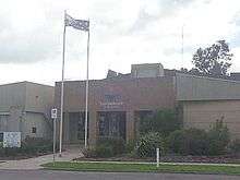
The council meets in the council chambers at the council headquarters in the Warracknabeal Municipal Offices, which is also the location of the council's administrative activities. It also provides customer services at both its administrative centre in Warracknabeal, and its service centres in Hopetoun and Rupanyup.
See also
References
- ↑ Australian Bureau of Statistics (27 June 2017). "Yarriambiack (S)". 2016 Census QuickStats. Retrieved 3 May 2018.

- 1 2 Victoria Government Gazette – Online Archive (1837–1997). "S4 of 1995: Order estg (Part 16) the Shire of Yarriambiack". State Library of Victoria. State Government of Victoria (published 20 January 1995). p. 6. Retrieved 10 January 2014.
- ↑ Local Government in Victoria. "Yarriambiack Shire Council". Department of Transport, Planning and Local Infrastructure. State Government of Victoria. Retrieved 10 January 2014.
External links
![]()
- Yarriambiack Shire Council official website
- Metlink local public transport map
- Link to Land Victoria interactive maps
Coordinates: 36°15′00″S 142°25′00″E / 36.25000°S 142.41667°E