Shire of Campaspe
| Shire of Campaspe Victoria | |||||||||||||||
|---|---|---|---|---|---|---|---|---|---|---|---|---|---|---|---|
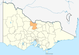 Location in Victoria | |||||||||||||||
| Population | 37,061 (2016 census)[1] | ||||||||||||||
| • Density | 8.2012/km2 (21.2409/sq mi) | ||||||||||||||
| Established | 1994 | ||||||||||||||
| Gazetted | 20 January 1995[2] | ||||||||||||||
| Area | 4,519 km2 (1,744.8 sq mi) | ||||||||||||||
| Mayor | Cr Adrian Weston | ||||||||||||||
| Council seat | Echuca | ||||||||||||||
| Region | Northern Victoria | ||||||||||||||
| State electorate(s) | Murray Plains | ||||||||||||||
| Federal Division(s) | Murray | ||||||||||||||
|
| |||||||||||||||
| Website | Shire of Campaspe | ||||||||||||||
| |||||||||||||||
The Shire of Campaspe is a local government area in Victoria, Australia, located in the northern part of the state. It covers an area of 4,519 square kilometres (1,745 sq mi) and at the 2016 census had a population of approximately 37,000[1].
It includes the towns of Girgarre, Echuca, Kyabram, Rochester, Tongala and Rushworth. It was formed in 1995 from the amalgamation of the City of Echuca, Shire of Deakin, Shire of Rochester, Shire of Waranga, Town of Kyabram and part of the Shire of Rodney.[2][3]
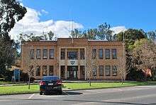
The Shire is governed and administered by the Campaspe Shire Council; its seat of local government and administrative centre is located at the council headquarters in Echuca, it also has service centres located in Kyabram, Rochester, Rushworth and Tongala. The Shire is named after the Campaspe River, a major geographical feature that meanders through the LGA.
Council
Current composition
The council is composed of five wards and nine councillors, with three councillors per ward elected to represent each of the Echuca and Kyabram-Deakin wards, and one councillor per remaining ward elected to represent each of the other wards.[4]
| Ward | Councillor | Notes | |
|---|---|---|---|
| Echuca | Daniel Mackrell | ||
| Annie Vickers | |||
| Kristen Munro | |||
| Kyabram Deakin | John Zobec | ||
| Neil Pankhurst | |||
| Vicki Neele | |||
| Rochester | Leigh Wilson | ||
| Waranga | Adrian Weston | ||
| Western | Leanne Pentreath | ||
Administration and governance
The council meets in the council chambers at the council headquarters in the Echuca Municipal Offices, which is also the location of the council's administrative activities. It also provides customer services at both its administrative centre in Echuca, and its service centres in Kyabram, Rochester, Rushworth and Tongala.
Sister cities


References
- 1 2 Australian Bureau of Statistics (27 June 2017). "Campaspe (S)". 2016 Census QuickStats. Retrieved 28 November 2017.

- 1 2 Victoria Government Gazette – Online Archive (1837–1997). "S4 of 1995". State Library of Victoria. State Government of Victoria (published 20 January 1995). p. 3. Retrieved 10 January 2014.
- ↑ Victoria Government Gazette – Online Archive (1837–1997). "S2 of 1995". State Library of Victoria. State Government of Victoria (published 19 January 1995). p. 2. Retrieved 10 January 2014.
- ↑ Local Government in Victoria. "Campaspe Shire Council". Department of Transport, Planning and Local Infrastructure. State Government of Victoria. Retrieved 10 January 2014.
- ↑ "International Friendships". Shire of Campaspe. Retrieved 2009-08-15.
External links
Coordinates: 36°21′40″S 144°44′02″E / 36.36111°S 144.73389°E