City of Wodonga
| Wodonga Council Victoria | |||||||||||||||
|---|---|---|---|---|---|---|---|---|---|---|---|---|---|---|---|
 Wodonga within Victoria | |||||||||||||||
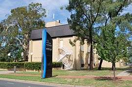 Council Offices in Wodonga | |||||||||||||||
| Population | 39,351 (2016 census)[1] | ||||||||||||||
| • Density | 90.88/km2 (235.38/sq mi) | ||||||||||||||
| Established | 1876 | ||||||||||||||
| Gazetted | 18 November 1994[2] | ||||||||||||||
| Area | 433 km2 (167.2 sq mi) | ||||||||||||||
| Mayor | Cr Anna Speedie | ||||||||||||||
| Council seat | Wodonga | ||||||||||||||
| Region | Hume | ||||||||||||||
| State electorate(s) | Benambra | ||||||||||||||
| Federal Division(s) | Indi | ||||||||||||||
|
| |||||||||||||||
| Website | Wodonga Council | ||||||||||||||
| |||||||||||||||
Wodonga Council is a local government area in the Hume region of Victoria, Australia, located in the north-east part of the state. It covers an area of 433 square kilometres (167 sq mi) and at the 2016 Census, had a population of over 39,000.
It is primarily urban with the vast majority of its population living in the Greater Wodonga urban area, while other significant settlements within the LGA include Bandiana and Bonegilla. Its floral and fauna emblems are pink heath and the Leadbeater's possum respectively—the same as those of the state of Victoria. It is one of only a few regional councils in Victoria to remain serving just one urban district after the amalgamation process of 1994, although through that process it did gained some portions of the former Shire of Chiltern and former Shire of Yackandandah.[2]
The city is governed and administered by the Wodonga Council; its seat of local government and administrative centre is located at the council headquarters in Wodonga. The city is named after the main urban settlement located in the north-east of the LGA, that is Wodonga, which is also the LGA's most populous urban centre with a population of 16,487.[3] It provides governance for the Victorian part of the Albury-Wodonga urban area.
History
Wodonga was first surveyed in 1852 and proclaimed the town of Belvoir in the same year. In 1876 the Victorian colonial government granted a request from the people of the area for their district to be severed from the Shire of Yackandandah to form a new municipality, and on 10 March 1876, the Shire of Wodonga was incorporated. On 12 April 1911 it annexed a further part of Yackandandah, and on 30 March 1973, Wodonga was proclaimed a Rural City by the Governor of Victoria, Sir Rohan Delacombe.[4][5]
The municipality survived widespread local government amalgamations in 1994, gaining the Baranduda and Barnawartha North districts from neighbouring shires.[6] However, the councillors were dismissed on 18 November 1994,[7] and replaced by commissioners Mel Read, a long-serving executive of the Albury-Wodonga Development Corporation, Des Kelly, a Shire of Tallangatta councillor from 1968 until 1994, and Mike Hansen, a retired army officer with management and logistics experience.[8] The commissioners decided in 1995 that, to give the city a fresh image, the term "rural" be dropped from use except when legally required.[5] It has since been officially renamed to the City of Wodonga. The elected council was reinstituted in 1997.
Council
Current composition
The current council is composed of seven councillors elected to represent an unsubdivided municipality.[9]
| Ward | Councillor | Notes | |
|---|---|---|---|
| Unsubdivided | Anna Speedie | Mayor | |
| Ron Mildren | |||
| Kat Bennett | |||
| Libby Hall | |||
| Tim Quilty | |||
| Danny Lowe | |||
| John Watson | |||
Former Wards and Structure
Prior to 1994, Wodonga was composed of four wards and twelve councillors, with three councillors per ward elected to represent each of the following wards:
- Baranduda Ward
- Belvoir Ward
- Bonegilla Ward
- Greenhill Ward
The council was replaced with three commissioners on 18 November 1994, and at the 1997 inaugural elections of the new council, five councillors were elected to an unsubdivided municipality. Following the enactment of the Local Government (Democratic Reform) Act 2003 (Vic.), which amended the Local Government Act 1989, an independent review of Wodonga's internal structure was commissioned and advertised on 13 May 2004 by the Victorian Government. The final report by the Victorian Electoral Commission, issued on 27 September 2004, recommended that the council be increased in size to seven elected members, noting that at the time of the report, Wodonga was the only city council with fewer than seven, and that the task of representing the diversity and issues of a growing regional city was complex. It recommended leaving the City unsubdivided as it had a single, dominant centre and a small area.[10]
The council was restructured accordingly and elections held on 26 November 2005 returned seven councillors with Rodney Wangman as mayor and Brian Wicks as deputy mayor.[11] Elections in late November 2008 resulted in four of the sitting seven councillors losing their seats, and saw the City of Wodonga gain a new Mayor and Deputy-Mayor, Crs Mark Byatt and Angela Collins respectively.
Administration and governance
The council meets in the council chambers at the council headquarters in the Wodonga Municipal Offices, which is also the location of the council's administrative activities. It also provides customer services at its administrative centre in Wodonga.
Geography
The City of Wodonga is dominated by the Wodonga urban area, which includes the suburb of West Wodonga and represents 37.1 square kilometres (14.3 sq mi), or 8.57%, of the City's area and at the 2006 census had a population of 29,710.[12]
Other towns within the City's area include:
- Bandiana
- Baranduda
- Barnawartha North
- Bonegilla
- Castle Creek
- Ebden
- Gateway Island
- Huon Creek
- Killara
- Leneva
- Staghorn Flat (shared with Indigo Shire)
Population
| Year | Population | Note(s) |
|---|---|---|
| 1954 | 10,924 | |
| 1958 | 12,520 | * |
| 1961 | 12,968 | |
| 1966 | 11,867 | |
| 1971 | 13,074 | |
| 1976 | 15,733 | |
| 1981 | 19,208 | |
| 1986 | 22,693 | |
| 1991 | 26,389 | |
| 1996 | 29,158 | |
| 2001 | 30,921 | |
| 2006 | 33,010 | |
| 2011 census | 35,519 | [13] |
| 2012 | 36,947 | |
| 2013 | 37,804 | |
| 2014 | 38,759 |
* Estimate in 1958 Victorian Year Book.
See also
References
- ↑ Australian Bureau of Statistics (27 June 2017). "Wodonga (C)". 2016 Census QuickStats. Retrieved 28 November 2017.

- 1 2 "Order Re-Consituting ... the Rural City of Wodonga ... (Part 4)". Victoria Government Gazette. State Government of Victoria (S87): 3. 18 November 1994. Retrieved 10 January 2014.
- ↑ Census QuickStats (2011). "Wodonga (SS) – SSC21487". Australian Bureau of Statistics. Government of Australia. Retrieved 10 January 2014.
- ↑ Victorian Municipal Directory. Brunswick: Arnall & Jackson. 1992. pp. 537–538. Accessed at State Library of Victoria, La Trobe Reading Room.
- 1 2 City of Wodonga (2 January 2008). "General history and what we do". Retrieved 7 January 2008.
- ↑ Australian Bureau of Statistics (1 August 1995). Victorian local government amalgamations 1994–1995: Changes to the Australian Standard Geographical Classification (PDF). Commonwealth of Australia. p. 12. ISBN 0-642-23117-6. Retrieved 5 January 2008.
- ↑ Gettler, Leon (19 November 1994). "North-east Victoria councils cut from 37 to 12". The Age. p. 10.
- ↑ Office of the Minister of Local Government (18 November 1994). "News Release – Twelve councils for north-east". Government of Victoria. Provisionally available at .
- ↑ Local Government in Victoria. "Wodonga City Council". Department of Transport, Planning and Local Infrastructure. State Government of Victoria. Retrieved 10 January 2014.
- ↑ Victorian Electoral Commission (27 September 2004). "Final Report – Electoral Representation Review – City of Wodonga" (PDF).
- ↑ City of Wodonga (19 December 2007). "Our councillors and senior staff". Retrieved 7 January 2008.
- ↑ Australian Bureau of Statistics (25 October 2007). "Albury-Wodonga (Wodonga Part) (Urban Centre/Locality)". 2006 Census QuickStats. Retrieved 7 January 2008. Map
- ↑ Census QuickStats (2011). "Wodonga (RC) – LGA27170". Australian Bureau of Statistics. Government of Australia. Retrieved 10 January 2014.
External links
- Wodonga City Council official website
- Metlink local public transport map
- Link to Land Victoria interactive maps
Coordinates: 36°07′00″S 146°53′00″E / 36.11667°S 146.88333°E