City of Hobsons Bay
| City of Hobsons Bay Victoria | |||||||||||||||
|---|---|---|---|---|---|---|---|---|---|---|---|---|---|---|---|
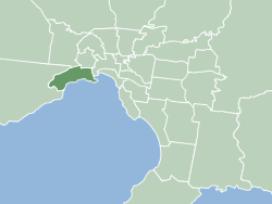 Location within Melbourne metropolitan area | |||||||||||||||
| Population | 88,778 (2016 census)[1] | ||||||||||||||
| • Density | 1,366/km2 (3,537/sq mi) | ||||||||||||||
| Established | June 1994 | ||||||||||||||
| Area | 65 km2 (25.1 sq mi) | ||||||||||||||
| Mayor | Cr Angela Altair | ||||||||||||||
| Council seat | Altona | ||||||||||||||
| Region | Metropolitan Melbourne | ||||||||||||||
| State electorate(s) | |||||||||||||||
| Federal Division(s) | |||||||||||||||
|
| |||||||||||||||
| Website | City of Hobsons Bay | ||||||||||||||
| |||||||||||||||
The City of Hobsons Bay is a local government area in Melbourne, Victoria, Australia. It comprises the south-western suburbs between 6 and 20 km from the Melbourne city centre.
It was founded on 22 June 1994 during the amalgamation of local councils by the state government from the City of Williamstown and the City of Altona, as well as the suburb of South Kingsville from the City of Footscray. It took its name from Hobsons Bay, named after Captain William Hobson. The city has an area of 65 square kilometres, and at the 2016 Census had a population of 88,778.
Council
The current council, as of December 2016, is:[2]
| Ward | Party | Councillor | Notes | |
|---|---|---|---|---|
| Cherry Lake | Independent | Sandra Wilson[3] | Mayor | |
| Independent | Tony Briffa JP[3] | |||
| Strand | Independent | Peter Hemphill[3] | ||
| Independent | Angela Altair[3] | |||
| Greens | Jonathon Marsden[3] | |||
| Wetlands | Independent | Colleen Gates[3] | Deputy Mayor | |
| Independent | Michael Grech[3] | |||
Education
Libraries
The library, run by the council has five branches: Altona, Altona Meadows, Altona North, Newport and Williamstown. Reflecting the multiculturalism of the community, the library service has a large amount of material in eight different languages.
The Environment Resource Centre is located in Altona library and provides the community access to resources concerning the environment, including initiatives and environmental groups in Hobsons Bay.
Transport
Suburban railway
Hobsons Bay has seven train stations on the Werribee railway line, in PTV Zones 1 and 2. These stations are Spotswood, Newport, Seaholme railway station, Altona, Westona, Laverton and Aircraft. Previously on this line were the stations of Mobiltown, Paisley, and Galvin.
Williamstown railway line is a shuttle service which is entirely located in Hobsons Bay. It departs the Werribee railway line at Newport and visits the stations of North Williamstown, Williamstown Beach, and Williamstown.
Buses
Twelve separate bus services operate in Hobsons Bay.
- Route 232: Altona North to Queen Victoria Market (via West Gate Freeway)
- Route 411: Laverton, Altona Meadows, Altona to Footscray (via Millers Road)
- Route 412: Laverton, Altona Meadows, Altona to Footscray (via Mills Street)
- Route : Laverton to Werribee Plaza (via Broadwalk Boulevard)
- Route 414: Aircraft railway station to Footscray
- Route 415: Laverton, Altona to Williamstown (via Civic Parade)
- Route : Aircraft railway station to Hoppers Crossing (via The Strand)
- Route 432: Newport to Yarraville
- Route 471: Williamstown to Sunshine (via Newport railway station and Altona Gate Shopping Centre)
- Route 472: Williamstown to Moonee Ponds (via Footscray)
- Route 903: Altona to Mordialloc (via Essendon), SmartBus service
Freeways
The interchange between the West Gate Freeway, Western Ring Road and Princes Freeway lies in the north-west of Hobsons Bay.
From Hobsons Bay, the West Gate Freeway provides access to the Melbourne CBD and eastern suburbs (over the iconic West Gate Bridge), the Princes Freeway provides access to outer south-western suburbs and Geelong, while the Western Ring Road leads to the northern suburbs and Melbourne Airport.
Suburbs
- Altona
- Altona Meadows
- Altona North
- Brooklyn (Shared with the City of Brimbank)
- Laverton (Shared with the City of Wyndham)
- Newport
- Seabrook
- Seaholme
- South Kingsville
- Spotswood
- Williamstown
- Williamstown North
Brisbane City
Sister Cities


See also
References
- ↑ Australian Bureau of Statistics (27 June 2017). "Hobsons Bay (C)". 2016 Census QuickStats. Retrieved 15 November 2017.

- ↑ "Mayor & Councillors". Hobsons Bay City Council.
- 1 2 3 4 5 6 7 "Greens make history in Hobsons Bay". Maribyrnong & Hobsons Bay Star Weekly. 3 November 2016.
- ↑ "International Exchange". List of Affiliation Partners within Prefectures. Council of Local Authorities for International Relations (CLAIR). Retrieved 21 November 2015.
External links
- Hobsons Bay City Council
- Hobsons Bay Community Online Forum
- Metlink local public transport map
- Link to Land Victoria interactive maps
- The Times - publisher of Hobsons Bay Times