Shire of Pyrenees
| Shire of Pyrenees Victoria | |||||||||||||||
|---|---|---|---|---|---|---|---|---|---|---|---|---|---|---|---|
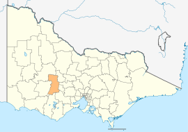 Location in Victoria | |||||||||||||||
| Population | 7,238 (2016 census)[1] | ||||||||||||||
| • Density | 2.1084/km2 (5.4606/sq mi) | ||||||||||||||
| Established | 1994 | ||||||||||||||
| Gazetted | 23 September 1994[2] | ||||||||||||||
| Area | 3,433 km2 (1,325.5 sq mi) | ||||||||||||||
| Mayor | Cr Tanya Kehoe | ||||||||||||||
| Council seat | Beaufort | ||||||||||||||
| Region | Western Victoria | ||||||||||||||
| State electorate(s) | Ripon | ||||||||||||||
| Federal Division(s) | Wannon | ||||||||||||||
|
| |||||||||||||||
| Website | Shire of Pyrenees | ||||||||||||||
| |||||||||||||||
The Shire of Pyrenees is a local government area (LGA) in Victoria, Australia, located in the western part of the state. It covers an area of 3,433 square kilometres (1,325 sq mi) and at the 2016 Census had a population of over 7,000.
It includes the towns of Avoca, Beaufort, Lexton and Trawalla. It was formed in 1994 from the amalgamation of the Shire of Avoca, Shire of Lexton and Shire of Ripon.[2][3]
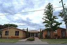
The Shire is governed and administered by the Pyrenees Shire Council; its seat of local government and administrative centre is located at the council headquarters in Beaufort, it also has a service centre located in Avoca. The Shire is named after the major geographical feature in the region, The Pyrenees Ranges which also gives its name to the Pyrenees wine region, which is located in the north of the Local Government Area.
Council
Current composition
The council is composed of five wards and five councillors, with one councillor per ward elected to represent each ward.[4]
| Ward | Councillor | Notes | |
|---|---|---|---|
| Avoca | Ron Eason | Mayor (2017) | |
| Beaufort | Michael O'Connor | ||
| De Cameron | Robert Vance | ||
| Ercildoune | David Clark | ||
| Mount Emu | Tanya Kehoe | ||
Administration and governance
The council meets in the council chambers at the council headquarters in the Beaufort Municipal Offices, which is also the location of the council's administrative activities. It also provides customer services at both its administrative centre in Beaufort, and its service centre in Avoca.
See also
References
- ↑ Australian Bureau of Statistics (27 June 2017). "Pyrenees (S)". 2016 Census QuickStats. Retrieved 28 November 2017.

- 1 2 Victoria Government Gazette – Online Archive (1837–1997). "S63 of 1994: Order estg the Shire of Pyrenees". State Library of Victoria. State Government of Victoria (published 23 September 1994). pp. 16–23. Retrieved 10 January 2014.
- ↑ Victoria Government Gazette – Online Archive (1837–1997). "S4 of 1995: Order altg (Part 12) the Shire of Pyrenees". State Library of Victoria. State Government of Victoria (published 20 January 1995). p. 5. Retrieved 10 January 2014.
- ↑ Local Government in Victoria. "Pyrenees Shire Council". Department of Transport, Planning and Local Infrastructure. State Government of Victoria. Retrieved 10 January 2014.
External links
- Pyrenees Shire Council official website
- Metlink local public transport map
- Link to Land Victoria interactive maps
- Avoca and District Historical Society Inc
- https://web.archive.org/web/20110203095139/http://www.moonambel-pyrenees.com/
Coordinates: 37°10′00″S 143°25′00″E / 37.16667°S 143.41667°E