Watten, Nord
| Watten | ||
|---|---|---|
| Commune | ||
 | ||
| ||
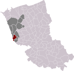 Watten in the arrondissement of Dunkirk | ||
| Coordinates: 50°50′01″N 2°12′47″E / 50.8336°N 2.213°ECoordinates: 50°50′01″N 2°12′47″E / 50.8336°N 2.213°E | ||
| Country | France | |
| Region | Hauts-de-France | |
| Department | Nord | |
| Arrondissement | Dunkerque | |
| Canton | Wormhout | |
| Intercommunality | CC Hauts de Flandre | |
| Government | ||
| • Mayor (2014-2020) | Daniel Deschodt | |
| Area1 | 7.32 km2 (2.83 sq mi) | |
| Population (2014)2 | 2,536 | |
| • Density | 350/km2 (900/sq mi) | |
| Time zone | UTC+1 (CET) | |
| • Summer (DST) | UTC+2 (CEST) | |
| INSEE/Postal code | 59647 /59143 | |
| Elevation |
1–73 m (3.3–239.5 ft) (avg. 55 m or 180 ft) | |
|
1 French Land Register data, which excludes lakes, ponds, glaciers > 1 km2 (0.386 sq mi or 247 acres) and river estuaries. 2 Population without double counting: residents of multiple communes (e.g., students and military personnel) only counted once. | ||
Watten (Dutch: Waden, meaning "ford" as in "river-crossing") is a commune in the Nord department in northern France.
Population (2006): 2,724 . Its inhabitants are called "Wattenais".
Geography
Watten is located at the limit of the French Flanders historical county. However, the local Dutch dialect (French Flemish) is virtually extinct. The neighbouring villages are Wattendam (commune of Holque), Millam, Serques, Éperlecques and Wulverdinghe.
While Watten belongs to the Nord département, it is bordering the Pas-de-Calais département. The village is crossed by the rivers Aa and Colme.
Politics
Presidential Elections 2nd Round
| Election | Winning Candidate | Party | % | |
|---|---|---|---|---|
| 2017 | Marine Le Pen | FN | 63.74 | |
| 2012 | François Hollande | PS | 63.30 | |
| 2007 | Nicolas Sarkozy | UMP | 55.82 | |
| 2002 | Jacques Chirac | RPR | 71.67 | |
Heraldry
.svg.png) |
The arms of Watten are blazoned : Per fess argent and gules, 3 pales counterchanged. |
Sights
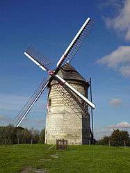
The village is famous for its old ruined abbey, and for its mill, which was restored in the 1990s. These two buildings are located on the "Mountain of Watten" (72 Meters high). Its church dates from the thirteenth century.
See also
References
- INSEE commune file
- Watten (in English)
| Wikimedia Commons has media related to Watten. |