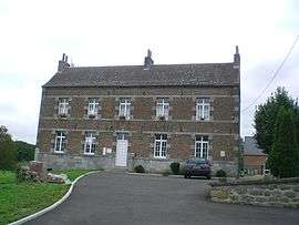
Damousies
| Damousies | ||
|---|---|---|
| Commune | ||
 | ||
| ||
 Damousies Location within Hauts-de-France region  Damousies | ||
| Coordinates: 50°13′12″N 4°00′52″E / 50.22°N 4.0144°ECoordinates: 50°13′12″N 4°00′52″E / 50.22°N 4.0144°E | ||
| Country | France | |
| Region | Hauts-de-France | |
| Department | Nord | |
| Arrondissement | Avesnes-sur-Helpe | |
| Canton | Fourmies | |
| Intercommunality | vallées de la Solre, de la Thure et de l'Helpe | |
| Government | ||
| • Mayor (2008–2014) | Bertrand Soil | |
| Area1 | 5 km2 (2 sq mi) | |
| Population (1999)2 | 236 | |
| • Density | 47/km2 (120/sq mi) | |
| Time zone | UTC+1 (CET) | |
| • Summer (DST) | UTC+2 (CEST) | |
| INSEE/Postal code | 59169 /59680 | |
| Elevation |
137–190 m (449–623 ft) (avg. 143 m or 469 ft) | |
|
1 French Land Register data, which excludes lakes, ponds, glaciers > 1 km2 (0.386 sq mi or 247 acres) and river estuaries. 2 Population without double counting: residents of multiple communes (e.g., students and military personnel) only counted once. | ||
Damousies is a commune in the Nord department in northern France.
Heraldry
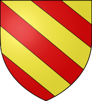 |
The arms of Damousies are blazoned : Bendy Or and gules. (Avesnes-sur-Helpe, Cartignies, Damousies, Dimechaux, Dimont, Felleries, Larouillies, Lomme, and Ramousies use the same arms.) |
See also
References
| Wikimedia Commons has media related to Damousies. |
This article is issued from
Wikipedia.
The text is licensed under Creative Commons - Attribution - Sharealike.
Additional terms may apply for the media files.