Maroilles, Nord
| Maroilles | ||
|---|---|---|
| Commune | ||
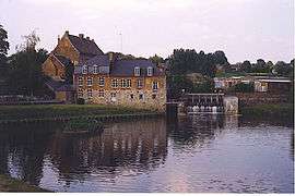 Mill on the Helpe Mineure. | ||
| ||
 Maroilles Location within Hauts-de-France region  Maroilles | ||
| Coordinates: 50°08′09″N 3°45′42″E / 50.1358°N 3.7617°ECoordinates: 50°08′09″N 3°45′42″E / 50.1358°N 3.7617°E | ||
| Country | France | |
| Region | Hauts-de-France | |
| Department | Nord | |
| Arrondissement | Avesnes-sur-Helpe | |
| Canton | Avesnes-sur-Helpe | |
| Intercommunality | Pays de Mormal et Maroilles | |
| Government | ||
| • Mayor (2008–2014) | Jean-Marie Sculfort | |
| Area1 | 22.13 km2 (8.54 sq mi) | |
| Population (1999)2 | 1,384 | |
| • Density | 63/km2 (160/sq mi) | |
| Time zone | UTC+1 (CET) | |
| • Summer (DST) | UTC+2 (CEST) | |
| INSEE/Postal code | 59384 /59550 | |
| Elevation |
125–191 m (410–627 ft) (avg. 186 m or 610 ft) | |
|
1 French Land Register data, which excludes lakes, ponds, glaciers > 1 km2 (0.386 sq mi or 247 acres) and river estuaries. 2 Population without double counting: residents of multiple communes (e.g., students and military personnel) only counted once. | ||
Maroilles is a commune in the Nord department in northern France.
Heraldry
.svg.png) |
The arms of Maroilles are blazoned : Argent, a stag's massacre gules surmounting a crozier palewise Or. (Marbaix, Maroilles, Noyelles-sur-Sambre, and Salesches use the same arms.) |
See also
References
| Wikimedia Commons has media related to Maroilles, Nord. |
This article is issued from
Wikipedia.
The text is licensed under Creative Commons - Attribution - Sharealike.
Additional terms may apply for the media files.