Estaires
| Estaires | ||
|---|---|---|
| Commune | ||
 | ||
| ||
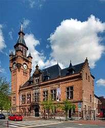
 Estaires Location within Hauts-de-France region  Estaires | ||
| Coordinates: 50°38′40″N 2°43′25″E / 50.6444°N 2.7236°ECoordinates: 50°38′40″N 2°43′25″E / 50.6444°N 2.7236°E | ||
| Country | France | |
| Region | Hauts-de-France | |
| Department | Nord | |
| Arrondissement | Dunkirk | |
| Canton | Hazebrouck | |
| Intercommunality | Flandre Lys | |
| Government | ||
| • Mayor (2008–2014) | Bruno Ficheux | |
| Area1 | 12.82 km2 (4.95 sq mi) | |
| Population (1999)2 | 5,690 | |
| • Density | 440/km2 (1,100/sq mi) | |
| Demonym(s) | Estairois, Estairoises | |
| Time zone | UTC+1 (CET) | |
| • Summer (DST) | UTC+2 (CEST) | |
| INSEE/Postal code | 59212 /59940 | |
| Elevation |
12–19 m (39–62 ft) (avg. 16 m or 52 ft) | |
|
1 French Land Register data, which excludes lakes, ponds, glaciers > 1 km2 (0.386 sq mi or 247 acres) and river estuaries. 2 Population without double counting: residents of multiple communes (e.g., students and military personnel) only counted once. | ||
Estaires is a commune in the Nord department in northern France.
Heraldry
_Nord-France.svg.png) |
The arms of Estaires are blazoned : Per fess argent and gules, a cross moline counterchanged. |
See also
References
| Wikimedia Commons has media related to Estaires. |
This article is issued from
Wikipedia.
The text is licensed under Creative Commons - Attribution - Sharealike.
Additional terms may apply for the media files.