Ghyvelde
| Ghyvelde Gijvelde | ||
|---|---|---|
| Commune | ||
 Ghyvelde in the arrondissement of Dunkirk | ||
| ||
 Ghyvelde Location within Hauts-de-France region  Ghyvelde | ||
| Coordinates: 51°03′08″N 2°31′41″E / 51.0522°N 2.5281°ECoordinates: 51°03′08″N 2°31′41″E / 51.0522°N 2.5281°E | ||
| Country | France | |
| Region | Hauts-de-France | |
| Department | Nord | |
| Arrondissement | Dunkirk | |
| Canton | Dunkerque-2 | |
| Intercommunality | CU Dunkerque | |
| Government | ||
| • Mayor (2016–2020) | Jean Decool | |
| Area1 | 35.92 km2 (13.87 sq mi) | |
| Population (2013)2 | 4,130 | |
| • Density | 110/km2 (300/sq mi) | |
| Demonym(s) | Ghyveldois | |
| Time zone | UTC+1 (CET) | |
| • Summer (DST) | UTC+2 (CEST) | |
| INSEE/Postal code | 59260 /59254 | |
| Elevation |
0–25 m (0–82 ft) (avg. 4 m or 13 ft) | |
|
1 French Land Register data, which excludes lakes, ponds, glaciers > 1 km2 (0.386 sq mi or 247 acres) and river estuaries. 2 Population without double counting: residents of multiple communes (e.g., students and military personnel) only counted once. | ||
Ghyvelde (Dutch: Gijvelde) is a commune in the Nord department in northern France. It is located on the Belgian border, and just inland from the North Sea. It is, after Bray-Dunes, the second most northern commune of France. The E40/A16 passes through the commune. On 1 January 2016, the former commune Les Moëres was merged into Ghyvelde.[1]
Gallery
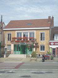
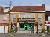 Town hall
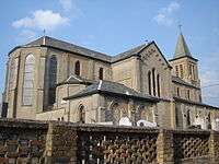 Saint-Vincent church
Politics
Presidential Elections 2nd Round
| Election | Candidate | Party | % | |
|---|---|---|---|---|
| 2017 | Marine Le Pen | FN | 52.67 | |
| 2012 | Nicolas Sarkozy | UMP | 50.03 | |
| 2007 | Nicolas Sarkozy | UMP | 55.94 | |
| 2002 | Jacques Chirac | RPR | 75.46 | |
Heraldry
_Nord-France.svg.png) |
The arms of Ghyvelde are blazoned : Ermine, on a bend gules, 3 escallops bendwise Or. (Ghyvelde and Hondschoote use the same arms.) |
See also
References
- ↑ Arrêté préfectoral 30 November 2015 (in French)
- ↑ http://www.lemonde.fr/nord-pas-de-calais-picardie/nord,59/ghyvelde,59260/elections/presidentielle-2017/
| Wikimedia Commons has media related to Ghyvelde. |
This article is issued from
Wikipedia.
The text is licensed under Creative Commons - Attribution - Sharealike.
Additional terms may apply for the media files.