Waharoa
Waharoa is a rural community 7 km north of Matamata in New Zealand. It is located at the railway junction of the Kinleith Branch railway with the East Coast Main Trunk Railway. State Highway 27 runs through the town.[1]
The Pa and Marae are the centre of the community.
Community
The community of Waharoa is very close - most people are of a single iwi.
Demographics
In 2013 77.1% of the population was Māori.[2]
| Year | Population | Households | Average income | National average |
|---|---|---|---|---|
| 2001 | 534 | 153 | $11,300 | $18,500 |
| 2006 | 507 | 150 | $14,400 | $24,100 |
| 2013 | 465 | 147 | $19,300 | $27,900[3] |
Schools
There are two primary schools, Waharoa School and Te Kura O Waharoa, with the majority of pupils being Māori. There are fewer than 100 children at each.
Local businesses
There is a service station in Waharoa. There is also an airfield that serves Matamata. The Four Square store is open again; it is on the main road over from the public toilets. There are a few cafes which serve fine hot beverages.
History
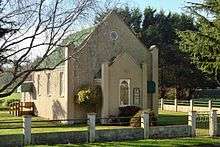
The current settlement, with church, school, dairy factory and ¼ acre-sections, was built in 1886 around the new railway station.[4] A new butter factory was built in 1921.[5] Another industry was the flax mill.[6]
Railway station
Waharoa had a station opposite Pitt St[7] on the Kinleith Branch from 8 March 1886.[8] It was rebuilt in 1923,[9] had a verandah added in 1924[10] and closed to passengers on 12 November 1968 and to freight on 29 March 1981.[8]
See also
References
- ↑ "Map of Wahora". Wises (via. Google). 2012. Retrieved June 9, 2012.
- ↑ "2013 Census QuickStats about a place". Retrieved 2018-05-14.
- ↑ "2013 Census map – QuickStats about a place". archive.stats.govt.nz. Retrieved 2018-05-14.
- ↑ "The Special Settlement at Matamata". New Zealand Herald. 1886-09-15. p. 6. Retrieved 2018-05-14.
- ↑ "Milk Powder Industry". Waikato Times. 1921-06-25. p. 6. Retrieved 2018-05-14.
- ↑ "Waharoa". Waikato Times. 1906-05-29. p. 2. Retrieved 2018-05-14.
- ↑ "Current and historical topographic maps (topomaps) of New Zealand". www.mapspast.org.nz. 1944. Retrieved 2018-05-14.
- 1 2 Scoble, Juliet (2010). "Names & Opening & Closing Dates of Railway Stations" (PDF). Rail Heritage Trust of New Zealand.
- ↑ "Appendix to the Journals of the House of Representatives — 1923 Session I-II — D-02 Page XXII". atojs.natlib.govt.nz. Retrieved 2018-05-14.
- ↑ "Appendix to the Journals of the House of Representatives — 1924 Session I — D-02 Page XLI". atojs.natlib.govt.nz. Retrieved 2018-05-14.