Waipa River
| Waipa River | |
|---|---|
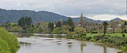 From Waingaro Rd bridge looking north down Waipa River to Ngaruawahia Point bandstand, the Waikato (coming from right) and the Hakarimata Range in the background (19-9-2012) | |
| Country | New Zealand |
| Physical characteristics | |
| Main source |
Rangitoto Range 703 m (2,306 ft) |
| River mouth |
Waikato River 20 m (66 ft) |
| Length | 115 km (71 mi) |
| Discharge |
|
| Basin features | |
| Basin size | 3,050 km2 (1,180 sq mi) |
| Tributaries |
|
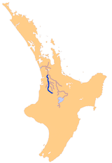
The Waipa River is in the Waikato region of the North Island of New Zealand. The headwaters are in the Rangitoto Range east of Te Kuiti. It flows north for 115 kilometres (71 mi), passing through Otorohanga and Pirongia, before flowing into the Waikato River at Ngaruawahia. It is the Waikato's largest tributary. The Waipa's main tributary is the Puniu River.
In the headwaters upstream of Otorohanga the river can be very clear during low flow conditions. This section of the river flows through rough farmland and patches of native bush. In this clearer part of the river there can be very good fly fishing for trout, but you'll need to ask the land owners permission to access the river.
The Waipa is prone to flooding in its lower reaches as flood flows can be over 100 times—20 to 560 m3/s (710 to 19,780 cu ft/s)—those of dry flows and the river can rise up to 11 m (36 ft).[1]
In 2013 Maniapoto Māori Trust Board and the riparian local councils set up a joint management agreement for the river.[2]
Speed of flow
The table below shows the time water takes to flow the 130 km (81 mi) from Te Kuiti to its confluence with the Waikato in times of low flow (15% of days are slower than this) and high flow (15% of days faster) -[3]
| time (hrs) | |||
|---|---|---|---|
| Place | km | low | high |
| Te Kuiti | 0 | 0 | 0 |
| Otorohanga | 37 | 20 | 13 |
| Pirongia | 73 | 40 | 25 |
| Whatawhata | 101 | 59 | 36 |
| Ngaruawahia | 130 | 98 | 49 |
Power stations
In 2003 Hydro Power Ltd was given consent to build a hydro-electric power station, with weirs in the Okahukura Stream, upstream from Owen Falls, and penstocks carrying water down the gorge[4] to a station on the west bank 2.5 kilometres (1.6 mi) below the falls.[5] Work was done in 2006,[6] but, in 2007, Hydro Energy (Waipa) Ltd was fined for unconsented damage to native vegetation in building the penstock.[7] The resource was initially estimated to be able to generate 10 to 20MW.[8] Construction halted, though Renewable Power bought the asset in 2010 and estimates potential at 9MW.[9]
In 2017 Nova Energy were given consent[10] to build a 360MW gas-turbine station (connected to the Maui Gas Pipeline) on the Ongaruhe Stream, close to its confluence with the Waipa.[11] The mid-merit Waikato Power Plant at 869 Kawhia Rd, Otorohanga is expected to be used for 10 to 15 minutes, 3 or 4 times a day.[12]
Pollution
Waikato Regional Council measures water quality monthly at five sites from Mangaokewa to Whatawhata.[13] The measurements show poor quality along most of the river, with excess nitrogen, silt and phosphorus, though E. coli levels have improved with improved sewage treatment, though generally not enough for safe swimming;[14] recreational rivers should have median E. coli levels below 126 per 100ml, but Waipa's range from 160 to 320.[15] Turbidity levels north of Otorohanga rise to more than double the levels needed to support plant photosynthesis[16] and phosphorus levels also rise above targets in that stretch.[17] Nitrogen levels increased at all five sites between 1993 and 2012 due to intensified land use,[18] now adding 3,075 tonnes a year. By comparison, the total from sewage works and Te Awamutu dairy factory is 66 tonnes.[19]
Ministry for the Environment figures[20] averaged between 1998 and 2007 showed the Waipa at Otorohanga had 280 E.coli per 100ml (53rd worst out of 154), 360 faecal coliforms per 100ml (83rd of 252), 0.55 mg/litre nitrogen (161th of 342) and 0.03 mg/litre phosphorus (187th of 361).
At Pirongia the figures were 390 E.coli per 100ml (35th worst out of 154), 425 faecal coliforms per 100ml (64th of 252), 0.49 mg/litre nitrogen (174th of 342) and 0.06 mg/litre phosphorus (80th of 361).
At Whatawhata the figures were 0.92 mg/litre nitrogen (94th of 342) and 0.06 mg/litre phosphorus (69th of 361).
In the Mangaokewa stream 0.02 mg/litre phosphorus (237th of 361).
Soil conservation
Regional Council estimates that 8,718 ha (21,540 acres) is at risk of severe erosion in the Middle Waipa (Waitomo, Turitea, Pirongia, Karakariki, Puniu, Mangaotama, Mangawhero and Mangapiko catchments) and 350 km (220 mi) of stream bank to be prone to erosion. Project Watershed plans for planting on 1,594 ha (3,940 acres), plus 976 km of stream bank and 1,332 km of fencing, from 2017 to 2026.[21]
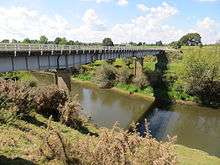
Bridges
Listed in order from the confluence with the Waikato and moving south they are:-
- 1898 Ngaruawahia bridge opened. Collapsed under a mob of cattle 20 December 1916 (see 1917 photo) and rebuilt in 1922 with three 110 ft (34 m) trusses.[22] The bridges were preceded by a punt (see 1922 photo), supplied by the government in 1887.[23] A new bridge was opened on 18 January 1974.[24]
- 1914-1958 Waipa Railway and Coal Co. 21 metres (70 ft) long[25] bridge.
- 1881 (20 April)Whatawhata bridge, originally wooden and 160 m (520 ft) long and 15 ft (4.6 m) above high water mark,[26] consisted of two spans of 24 m (80 ft), 7 of 40 and 4 of 6.1 m (20 ft), and cost £3700. Repairs were done in 1909, but it was in poor repair again by 1917. For £11,250 a new truss bridge was built over the top of it in 1924.[27] The current SH23 concrete bridge, which is south of the original site, was shown on the 1974 edition of the 1 inch Lands & Survey map, but not on the 1965 3rd edition. Records of the road structure show it dates from 1971,[28] which is probably the date of the bridge. The bridge replaced a punt, which had operated from 1867.[29]
- 1881 (12 August) 120-metre (400 ft) long Te Rore bridge. Replaced 1957.[30]
- 1865 (about) Alexandra Bridge, Baffin St, Pirongia, originally built by the army.[31] Pukehoua Bridge was built 600 m (660 yd) upstream in 1912-13 to replace the 1865 bridge, which was damaged by floods and by 1909 was only fit for pedestrians and light traffic. Public Works Department estimated its cost at £4,500, £1,500 coming from Government and £3,000 from Waipa (50%), Raglan (30%) and Waitomo (20%) councils.[32]
- 1882 Alexandra Bridge, McClure St, Whatiwhatihoe, Pirongia."Mr. Wright has superintended the construction of the Alexandra Bridge, over the Waipa River, to give access to Tāwhiao's new settlement, Whatiwhatihoe (see map), and which will at the same time eventually be on the main line leading into the King country. The bridge will be open now in a fortnights' time, it consists of six 7.3 m (24 ft) spans, and three 12 m (40 ft) trusses, a total length of 80 m (264 ft), the height being 13 m (42 ft) above ordinary river level. The approaches and about a mile of road, and a large culvert have been made by Mr. Wright, with Maori labor. The whole will have been completed at a cost of about £1,800."[33] There was a plan to replace it in 1939.[34] SH39 now crosses on a 112.8-metre-long (370 ft) 1953 bridge.[35]
- 1915 Te Kawa Rd bridge 100 metres (340 ft) long, 12 metres (40 ft) high.[36]
- Kawhia Rd, Otorohanga, SH31/SH39 cross on a 147.5-metre-long (484 ft) 1964 bridge.[37]
- Maniapoto St, Otorohanga photo about 1910 SH3 now crosses on a 51.8-metre-long (170 ft) 1964 bridge.[38] It replaced a bridge built in the early 1950s.[39]
- 1887 North Island Main Trunk railway bridge.
- 1928 Toa Bridge, Otewa Rd.[40]
Steamer services
Over 50 kilometres (31 mi) was navigable by waka and Pirongia (Alexandra) was busy as the head of steamboat navigation until the railway was built to Te Awamutu in 1880,[27] though some settlers used it as far as Te Kuiti.[41] From 1902[42] to 1909 H H Gould ran the 1899 5hp SS Opuatia[43] from Ngaruawahia to Whatawhata one day and on to Pirongia next day.[44] A 1915 guidebook still said, "Small steamers ply up and down the river from Huntly".[45] An 1881 article said a journey upriver would normally take 36 hours, but more in dry weather, when shoals at Whatawhata and Te Rore were hard to cross.[46] An 1898 petition complained about wharfage charges at Mercer being a tax on residents along the Waipa.[47] Around 1900 the Freetrader, owned by the Waikato Company, "was withdrawn owing to competition from the Walsh brothers with their launch Victory, which could traverse the winding Waipa much more easily than the cumbersome stern-wheeler."[48]
As late as 1919 Waipa County Council pressed for removal of shingle shoals to permit navigation to Pirongia[49] and got money for improvements from government[50] and the county councils.[51] Evidence given to the Inland Waterways Commission in 1921 said boats carrying 20 tons could reach Pirongia for most of the year and, up to about 30 years before, vessels carried 60 tons to Pirongia and a special fleet of steamers ran to Te Kuiti.[52] Steamers seem to have ended with the sinking of the Opuatia at Whatawhata in 1920.[53]
References
- ↑ "Waikato Regional Council - River level at Whatawhata". riverlevelsmap.waikatoregion.govt.nz. Retrieved 2017-01-21.
- ↑ "Historic Waipa River agreement signed at Te Kuiti Pa - Waipa District Council". www.waipadc.govt.nz. Retrieved 2017-04-30.
- ↑ Brown, Edmund (2005). "Hydraulic Travel Times of Major Waikato Rivers" (PDF). Environment Waikato. p. 20.
- ↑ "Hydro power scheme consent for Waipa River approved". Waikato Regional Council. Retrieved 2017-02-05.
- ↑ "New hydro-electric power station proposed". Waikato Regional Council. Retrieved 2017-02-05.
- ↑ "Site HM1 – Waipa at Otewa" (PDF). NIWA. January 2009.
- ↑ "Hydro developer hit with big fine for 'environmental vandalism'". Waikato Regional Council. Retrieved 2017-02-05.
- ↑ "Hydropower Projects". www.riley.co.nz. Retrieved 2017-02-05.
- ↑ "Current Projects". renewable-power.co.nz. Retrieved 2017-02-05.
- ↑ "Nova Energy granted council consents for gas-fired power station". Waikato Regional Council. Retrieved 2017-05-04.
- ↑ "Nova Energy (Land Use Consent Application) » Otorohanga District Council". www.otodc.govt.nz. Retrieved 2017-02-05.
- ↑ "Notice of Meeting" (PDF). Waikato Regional Council. 25 May 2017.
- ↑ map of pollution monitoring sites.
- ↑ "Trends in Waipa River water quality". Waikato Regional Council. Retrieved 2017-01-18.
- ↑ "Changes in bacteria levels". Waikato Regional Council. Retrieved 2017-01-18.
- ↑ "Changes in turbidity". Waikato Regional Council. Retrieved 2017-01-18.
- ↑ "Changes in phosphorus". Waikato Regional Council. Retrieved 2017-01-18.
- ↑ Trends in Waipa River water quality
- ↑ Vant, Bill (16 April 2015). "Sources of contaminants to rivers in the Waikato region" (PDF). Waikato Regional Council.
- ↑ http://www.mfe.govt.nz/publications/water/water-quality-trends-1989-2007/index.html
- ↑ "Project Watershed works identified for middle Waipa". Waikato Regional Council. Retrieved 2017-02-05.
- ↑ "PUBLIC WORKS STATEMENT BY THE HON. J. G. COATES, MINISTER OF PUBLIC WORKS. (Appendix to the Journals of the House of Representatives, 1922-01-01)". paperspast.natlib.govt.nz National Library of New Zealand. Retrieved 2017-07-01.
- ↑ Waikato Times, Volume XXIII, Issue 2271, 29 January 1887, Page 3: MR BALLANCE AT OTOROHANGA – The Special Settlements
- ↑ Latta, A. M. (1980). Meeting of the Waters. Ngaruawahia Lions Club.
- ↑ New Zealand Herald, Volume XLIX, Issue 14940, 13 March 1912, Page 8
- ↑ Waikato Times 2 Oct 1880
- 1 2 C. W. Vennell; Susan Williams (1976). Raglan County Hills and Sea: A Centennial History 1876–1976. Wilson & Horton for Raglan County Council. ISBN 978-0-86864-002-0.
- ↑ "Highway Information Sheet 023-0011" (PDF). NZTA. May 2015.
- ↑ "WHATAWHATA. (New Zealand Herald, 1867-01-14)". paperspast.natlib.govt.nz National Library of New Zealand. Retrieved 2017-06-15.
- ↑ http://www.teawamutuinfo.com/acatalog/Waipa_Heritage_Trail.html
- ↑ Waikato Times 21 September 1880, Page 2
- ↑ "NEWSLETTER 34, November, 2013". Pirongia Heritage & Information Centre.
- ↑ 1882 Surveys of New Zealand report
- ↑ New Zealand Herald 21 January 1939, Page 18
- ↑ "Highways Information sheet 039-0043" (PDF).
- ↑ New Zealand Herald, 3 February 1915, Page 9
- ↑ "Highway Information sheet 031-0000" (PDF).
- ↑ "Highway Information sheet 003-0057" (PDF).
- ↑ "Appendix to the Journals of the House of Representatives — 1950 Session I — D-01 Page 41". atojs.natlib.govt.nz AtoJs Online. Retrieved 2017-07-04.
- ↑ http://legislation.knowledge-basket.co.nz/gpacts/public/text/1928/se/048se11.html
- ↑ "AtoJs Online — Appendix to the Journals of the House of Representatives — 1921 Session I-II — H-15a AUCKLAND CANALS AND INLAND WATERWAYS COMMISSION. (REPORT OF THE)". atojs.natlib.govt.nz. Retrieved 2016-06-22.
- ↑ "Page 3 Advertisements Column 1". Waikato Argus. 1902. p. 3. Retrieved 2018-04-22.
- ↑ "Appendix to the Journals of the House of Representatives 1899 Session I MARINE DEPARTMENT: ANNUAL REPORT FOR 1898-9". paperspast.natlib.govt.nz. Retrieved 2018-04-28.
- ↑ "Page 4 Advertisements Column 4". Waikato Argus. 1909-06-03. p. 4. Retrieved 2018-04-22.
- ↑ The Raglan and Kawhia Districts: E E Bradbury 1915 page 49
- ↑ Waikato Times, Volume XVI, Issue 1375, 26 April 1881, Page 3
- ↑ "WHATAWHATA. (Waikato Argus, 1898-09-10)". paperspast.natlib.govt.nz National Library of New Zealand. Retrieved 2017-06-18.
- ↑ "WAIKATO'S STEAMERS. (New Zealand Herald, 1932-04-01)". paperspast.natlib.govt.nz. National Library of New Zealand. Retrieved 2016-10-23.
- ↑ "LOCAL AND GENERAL. (Waikato Times, 1919-09-10)". paperspast.natlib.govt.nz. National Library of New Zealand. Retrieved 2017-01-18.
- ↑ "PUBLIC WORKS ESTIMATES (Waikato Times, 1919-10-25)". paperspast.natlib.govt.nz. National Library of New Zealand. Retrieved 2017-01-28.
- ↑ "LOCAL AND GENERAL. (King Country Chronicle, 1919-12-13)". paperspast.natlib.govt.nz. National Library of New Zealand. Retrieved 2017-01-28.
- ↑ "NAVIGATION OF WAIPA (Waikato Times, 1921-04-18)". paperspast.natlib.govt.nz National Library of New Zealand. Retrieved 2017-02-21.
- ↑ "CAUGHT BY THE FLOOD. (New Zealand Herald, 1920-04-09)". paperspast.natlib.govt.nz National Library of New Zealand. Retrieved 2017-06-18.
External links
- Regional Council summary of information about the river.
- Regional Council water quality information at Whatawhata, Pirongia, Otorohanga, Mangaokewa and water temperatures at Otorohanga, and Whatawhata.
- Maps of Waipa and tributary stream catchments - Ngaruawahia/Whatawhata, Pirongia/Te Awamutu, Otorohanga/Te Kuiti, south east.
- Maps of pollution - phosphorus, bacteria and turbidity.
- River levels at Ngaruawahia, Whatawhata, Pirongia, Otorohanga, Waitomo, Te Kuiti, Otewa.
- Waipa Catchment Plan 2014
- Regional Council lists of actions and conservation areas to support the Waipa Catchment Plan in 2014/15.
- Encyclopaedia of New Zealand short history
- Lower Waipa flood control scheme
- Description of fishing in Waipa and tributaries
- 1864 photo of confluence of Waipa and Waikato
- 1910 photos of Waipa Bridge at Ngaruawahia - , and .
- 1910 photo of steam barge delivering goods
- 1914 photo of barge and steam tug
- 1917 photo of barge, steam tug and factory
- 1922 photo of new Ngaruawahia bridge being built
- 1951 photo of Waipa Railway bridge
- 1880s photos of Whatawhata Bridge, close up and 1924 rebuilding
- 1907 photo of bridge at Otorohanga
- Geological maps - 1925 Ngaruawahia, Whatawhata-Te Pahu, Pirongia, 1940 Otorohanga, upper Waipa and Pakaumanu.
- 1:50,000 map of source of Waipa River