Turangi
| Turangi | |
|---|---|
 Turangi | |
| Coordinates: 38°59′20″S 175°48′30″E / 38.98889°S 175.80833°ECoordinates: 38°59′20″S 175°48′30″E / 38.98889°S 175.80833°E | |
| Country |
|
| Region | Waikato |
| Territorial authority | Taupo District |
| Ward | Turangi-Tongariro |
| Electorate | Taupo |
| Government | |
| • Mayor | Rick Cooper |
| Elevation | 380 m (1,250 ft) |
| Population (June 2018)[1] | |
| • Total | 3,320 |
| Time zone | UTC+12 (NZST) |
| • Summer (DST) | UTC+13 (NZDT) |
| Postcode | 3334 |
| Area code(s) | 07 |
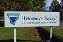
Turangi is a small town on the west bank of the Tongariro River, 50 kilometres south-west of Taupo on the North Island Volcanic Plateau of New Zealand. It was built to accommodate the workers associated with the Tongariro hydro-electric power development project and their families. The town was designed to remain as a small servicing centre for the exotic forest plantations south of Lake Taupo and for tourists. It is well known for its trout fishing and calls itself "The trout fishing capital of the world". The major Māori hapu (tribe) of the Turangi area is Ngāti Tūrangitukua.
Geography
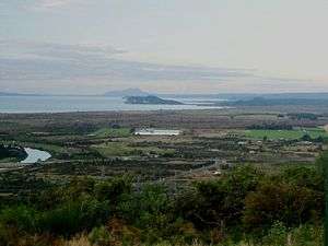
The Turangi area covers some 2273 km², and is located close to the edge of the Kaimanawa Ranges and ten kilometres north of the stretch of State Highway 1 known as the Desert Road.
The streets around Turangi in autumn are lined with “brilliant” foliage.[2]
Built on the banks of the Tongariro River, Turangi and its surrounding countryside offers challenging hunting, fishing, mountain biking, hiking or leisurely bush walks, white water rafting, kayaking and sight seeing.[3]
Population and demographics
The town has a population of around 3500, and it is (after Taupo) the second largest population centre in the Taupo District. Turangi's population peaked at 9000 during the 1970s. Since the end of the Project in the 1980s the population has declined but has remained stable due to the town's handy location for tourists.
Economy
Tourism and forestry are the mainstay of the community with the Department of Corrections two prisons, Genesis Energy, the Department of Conservation and farming being the main employers. The town is also home to a Centre for Sustainable Practice at Awhi Farm, providing education and enterprise training.
History
Māori settlement
The area was settled by the people of Ngati Tuwharetoa, descendants of those who had originally settled in the Kawerau area. The major Tuwharetoa migration occurred from about the 16th century with a war party under command of Turangitukua who engaged in a number of battles against earlier inhabitants of the Taupo, Rotoaira and Kaimanawa area.[4] Following these battles a variety of settlements were established in the area with major pa established on the cliff overlooking the Tongariro River and at Waitahanui on the Tongariro Delta. Another important settlement was at Tokaanu.
The people who eventually become known as Ngati Turangitukua associate mainly with Waitahanui pa. From here they established a number of homesteads along both sides of the Tongariro River and its tributaries. Including houses along the main Highway to Taumarunui (now Hirangi Road) In 1910 construction of a wharepuni begun which eventually became the Hirangi Marae complex.[5]
.JPG)
Non-Māori settlement
The first Europeans reached the Turangi area in the 1830s,[6] however it was not until the 1850s that European settlement occurred with the construction of a Mission Station at Pukawa.
In the 1880s and 1890s brown and rainbow trout were introduced into the lake and rivers of the area. A small fishing camp was established at Taupahi on the Tongariro river bank (now Taupahi Road) and a number of European fisherman camped here.
In the 1920s two prison farms were opened at Rangipo and Hautu[6] because of the isolated nature of the area. Also during this period the Morar family arrived from India, settling and establishing a store in Tokaanu.
By 1960 the population was about 500.[6]
Tongariro power development
In the 1950s, in response to post World War II needs for rapid expansion of energy resources to meet the growing industrialisation in New Zealand, the Tongariro Power Scheme proposal was developed. The scheme would require a large construction force, and provide accommodation for that force for the duration of the project.
Four sites were considered for the township to accommodate the project workers: Rotoaira, Rangipo, Turangi West, and Turangi East. The tourism potential of Lake Taupo was appreciated, as well as the economic benefits that could be captured by creating a permanent township. Taking in account accessibility, climate, and adequacy of suitable land for development of a township, it was decided to go with the Turangi West site.
Construction of the town began late in 1964.[6] The Government invested $16 million [6] in the development and by May 1966, the population of Turangi had jumped from 500 to 2,500[6] people. By 1968 the population reached a high of 6,500.[6] A model town with curving streets and cul-de-sacs, uniform houses, pedestrian shopping centre, parking lots and separation from the traffic on the main highway was created.[6]
A publicity pamphlet published by the Ministry of Works in 1969 described Turangi at that time as a pleasant and attractive town of 5000 people which offered a ‘balanced community life’. The pamphlet enumerated the town's amenities, shops, and services, such as its mall, schools, sports facilities, library, maternity hospital, parks, and, not least, its wide, grassy verges and kerbing.[7]
Following the completion of the project in the late 1970s,[6] the Ministry of Works and other government departments began a process of selling assets [6] within the Turangi township.
Treaty settlement
In 1989 Ngati Turangitukua registered with the Waitangi Tribunal (Wai 84) The claim was heard under urgency between April and October 1994, and the Tribunal's Report was released in September 1995.
The Tribunal found that the Crown had breached the principles of the Treaty of Waitangi in a number of ways:
- The Crown acquired Māori land at Turangi West when Crown land at Turangi East was available:
- The Crown did not adequately consult with Ngati Turangitukua regarding the construction of the township:
- The land taken for the township was in excess of the maximum area that the Crown promised it would take:
- The land the Crown undertook to lease for industrial purposes and return to the people after 10 to 12 years was compulsorily acquired and not returned:
- Wahi tapu were destroyed or damaged in the construction of the township:
- Adequate compensation was not paid for land acquired:
- The Crown did not give full effect to conservation values:
- The Crown did not pay Ngati Turangitukua the respect due its mana as tangata whenua:
- The provisions of the Public Works Act 1928 and the Turangi Township Act 1964, relied on by the Crown in entering and taking the claimants' land, are inconsistent with the basic guarantee in Article II of the Treaty of Waitangi that Māori may keep their land until such time as they wish to sell it.
- The Tribunal found that, as a result of the Crown's breaches of the principles of the Treaty, Ngati Turangitukua lost much of its ancestral land. Its social and economic base was seriously eroded causing spiritual, cultural, and economic prejudice to Ngati Turangitukua.
In July 1998,[8] the Crown and Ngati Turangitukua negotiated to achieve a full and final settlement of Ngati Turangitukua's Treaty claims and to remove the continuing sense of grievance.
The Crown and Ngati Turangitukua entered into a deed of settlement on 26 September 1998,[9] resulting in a full and final settlement of Ngati Turangitukua's Treaty claims relating to the development and construction of the Turangi Township and its after effects.
In 1999 the Ngati Turangitukua Claims Settlement Act 1999 was passed to:[10]
(a) To record the apology given by the Crown to Ngati Turangitukua in the deed of settlement executed on 26 September 1998 by the Minister in Charge of Treaty of Waitangi Negotiations, the Right Honourable Sir Douglas Arthur Montrose Graham, for the Crown, and Ngati Turangitukua; and
(b) To give effect to certain provisions of that deed of settlement, being a deed that settles the Ngati Turangitukua claims.
Government
.JPG)
Turangi is located in the administrative areas of the Taupo District Council and three of the council's eleven representatives is elected directly from a Turangi Tongariro ward.[11] Turangi is administered [11] by the Turangi/Tongariro Community Board under delegated powers from the Taupo District Council. This ensures that all locally important decisions are made by local residents.
The role of the Turangi Tongariro Community Boards is to:[11]
- Represent and act as an advocate for, the interests of its communities.
- Consider and report on all matters referred to it by Council, or any matter of interest to the community board.
- Maintain an overview of services provided by Council within the community.
- Prepare an annual submission to Council on expenditure within the community.
- Communicate with community organisations and special interest groups within the community.
The Taupo District is itself part of the Waikato Region, controlled administratively by the Environment Waikato.
Turangi is part of the Taupo electorate in New Zealand's general elections. The electorate is currently represented in the New Zealand Parliament by Louise Upston (National).
Education
There are three schools in the Turangi area. Within the Turangi township are two schools, both area schools which cater for Year 1 to 13 students. The schools opened in February 2004, following the Turangi Education Network Review that resulted in the closure [12] of four schools:
- Hirangi Primary, Turangi Primary, Tongariro High and Tauranga-Taupo Primary Schools were closed. Previously Pihanga Primary existed, but was closed in the mid 1980s.
- A single Year 1 – 15 composite school was established (Tongariro School).
- A Wharekura for Year 1 – 13 students who wish to receive their education in te reo Māori, was established (Te Kura o Hirangi).
The third school is a rural school at Kuratau approximately 30 km west of Turangi on SH 41 to Taumarunui.
Sister city
References
- ↑ "Subnational Population Estimates: At 30 June 2018 (provisional)". Statistics New Zealand. 23 October 2018. Retrieved 23 October 2018. For urban areas, "Subnational population estimates (UA, AU), by age and sex, at 30 June 1996, 2001, 2006-18 (2018 boundary)". Statistics New Zealand. 23 October 2018. Retrieved 23 October 2018.
- ↑ Lynda Topp. "Rainbow Trout Lodge - Guestbook". Rainbow Trout Lodge. Retrieved 2006-07-13.
- ↑ Lake Taupo Think Fresh (2005). "Free things to do around Lake Taupo" (PDF). laketauponz.com/. Retrieved 2006-07-13.
- ↑ J T Grace Tuwharetoa A History of the Maori People of the Taupo District Reed 1959
- ↑ Hirangi Marae Archives
- 1 2 3 4 5 6 7 8 9 10 "Welcome To Turangi - Top Of The Lake". Laketaupo.co.nz. Retrieved 2006-07-13.
- ↑ Ministry of Works (1969). "This is Turangi". This is Turangi.
- ↑ "Tribunal delivers report on remedies in the Turangi Township claim" (PDF) (Press release). Waitangi Tribunal. 8 July 1998. Retrieved 2006-06-15.
- ↑ "Ngati Turangitukua Deed of Settlement" (PDF). Archived from the original (PDF) on 2010-05-21. Retrieved 2006-06-15.
- ↑ "Ngati Turangitukua Claims Settlement Act 1999". Retrieved 2006-06-15.
- 1 2 3 Taupo District Counci. "Turangi Tongariro". Taupo District Counci. Archived from the original on 2006-05-14. Retrieved 2006-07-13.
- ↑ "Closure Notice Hirangi School (2541) etc". New Zealand Gazette. 2003. Retrieved 2006-07-13.
External links
| Wikivoyage has a travel guide for Turangi. |
- Turangi Official Visitor Information site
- Turangi and Lake Taupo website
- Turangi, Kiwi Tourism
- Awhi Farm Centre for Sustainable Practice
| Authority control |
|---|