Braničevo District
| Braničevo District Браничевски округ Braničevski okrug | |
|---|---|
| District of Serbia | |
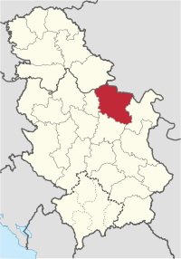 Location of the Braničevo District within Serbia | |
| Coordinates: 44°37′N 21°11′E / 44.617°N 21.183°ECoordinates: 44°37′N 21°11′E / 44.617°N 21.183°E | |
| Country |
|
| Region | Southern and Eastern Serbia |
| Administrative center | Požarevac |
| Government | |
| • Commissioner | Aleksandar Đokić |
| Area | |
| • Total | 3,865 km2 (1,492 sq mi) |
| Population (2011 census) | |
| • Total | 180,480 |
| • Density | 46.7/km2 (121/sq mi) |
| ISO 3166 code | RS-11 |
| Municipalities | 7 and 1 city |
| Settlements | 189 |
| - Cities and towns | 7 |
| - Villages | 182 |
| Website |
branicevski |
The Braničevo District (Serbian: Браничевски округ/Braničevski okrug; pronounced [brǎnitʃɛv̞skiː ôkruːɡ], derived from [brǎnitʃɛv̞ɔ]) is one of nine administrative districts of Southern and Eastern Serbia. It expands in the north-eastern parts of Serbia. According to the 2011 census results, it has a population of 180,480 inhabitants. The administrative center of the district is Požarevac.
History
In the 9th century, a Slavic (or Serb[1]) tribe known as Braničevci are mentioned living in the region. In this time, the town named Braničevo also existed in the area, at the estuary of the river Mlava into Danube. In the Early Middle Ages, Braničevo became a part of the First Bulgarian Empire. After the conquest of Bulgaria, the Byzantines established the Theme of Sirmium in the wider region south of the river Danube. Syrmia, and hence Braničevo, came to be contested between Kingdom of Hungary on the one side, and the Byzantine Empire and the Second Bulgarian Empire (after its independence from the Byzantines) on the other. In the 13th century the Hungarians established the Banate of Braničevo (Banovina of Braničevo), but later in the century two local Bulgarian rulers, Darman and Kudelin, became independent and ruled over Braničevo and Kučevo. In 1291, they were defeated by the Serbian king, Stefan Dragutin, who joined Braničevo to his Syrmian Kingdom. Under his rule the town of Braničevo became a seat of the Eparchy of the Serbian Orthodox Church.[2] The region later belonged to subsequent Serbian states, until it was conquered by the Ottoman Empire in the 15th century. In the 14th century, the region was in a possession of local rulers from the House of Rastislalić. During the Ottoman rule, Braničevo was part of the Sanjak of Smederevo, and since 19th century, it is again part of the Serbian state.
Culture
In the mid-nineteenth century, at the time of the Serbian state emancipation, Požarevac became, along with Kragujevac, the second metropolis of Prince Miloš Obrenović. During his lifetime, Prince Miloš Obrenović had erected monuments to his memory in Požarevac:
- the church in 1819
- palace (1825)
- new marketplace (1827)
- stud-farm - Ljubicevo in 1860.
Some of the places of cultural importance in Požarevac are:
- the National Museum (the first built after Belgrade)
- the Tulba Ethnic Park (a unique outdoor museum)
- Gallery of Paintings of Milena Pavlović-Barili (a distinguished surrealistic artist and poet).
Municipalities
The district encompasses the municipalities of:

Economy
Business facilities of this district are concentrated in the vicinity of the cities of Požarevac and Costal. The most prominent is the food-industry giant: Agricultural-industrial Combine Požarevac which provides employment to a huge number of men and satisfies one quarter of the overall demands of Serbia.
Demographics
| Historical population | ||
|---|---|---|
| Year | Pop. | ±% |
| 1948 | 246,859 | — |
| 1953 | 259,329 | +5.1% |
| 1961 | 263,780 | +1.7% |
| 1971 | 263,466 | −0.1% |
| 1981 | 264,182 | +0.3% |
| 1991 | 253,992 | −3.9% |
| 2002 | 200,806 | −20.9% |
| 2011 | 183,625 | −8.6% |
| Source: [3] | ||
According to the 2011 census results, the Braničevo District has a population of 183,625 inhabitants.
Ethnic groups
Ethnic composition of the Braničevo district:[4]
| Ethnic group | Population |
|---|---|
| Serbs | 155,255 |
| Vlachs | 13,238 |
| Romani | 4,629 |
| Romanians | 728 |
| Macedonians | 282 |
| Montenegrins | 242 |
| Croats | 189 |
| Yugoslavs | 160 |
| Hungarians | 108 |
| Others | 8,794 |
| Total | 183,625 |
See also
References
- ↑
- ↑ Fine, John V.A. (1994). The Late Medieval Balkans: a critical survey from the late twelfth century to the Ottoman conquest. University of Michigan Press. p. 261. ISBN 9780472082605.
- ↑ "2011 Census of Population, Households and Dwellings in the Republic of Serbia" (PDF). stat.gov.rs. Statistical Office of the Republic of Serbia. Retrieved 13 January 2017.
- ↑ "Попис становништва, домаћинстава и станова 2011. у Републици Србији" (PDF). stat.gov.rs. Republički zavod za statistiku. Archived from the original (PDF) on 11 August 2014. Retrieved 13 January 2017.
Note: All official material made by the Government of Serbia is public by law. Information was taken from www
External links
| Wikimedia Commons has media related to Braničevo District. |
- Braničevski upravni okrug (Serbian)
Places adjacent to Braničevo District | ||||||||||
|---|---|---|---|---|---|---|---|---|---|---|
| ||||||||||