Tirumala
| Tirumala Adivarahakshetra, Venkatadri | |
|---|---|
| Census Town | |
 Lord Venkateswara Temple | |
| Nickname(s): Kaliyuga Vaikunta | |
 Tirumala Location in Andhra Pradesh, India | |
| Coordinates: 13°39′00″N 79°25′12″E / 13.6500°N 79.42°ECoordinates: 13°39′00″N 79°25′12″E / 13.6500°N 79.42°E | |
| Country | India |
| State | Andhra Pradesh |
| District | Chittoor |
| Mandal | Tirupati (rural) |
| Area[1] | |
| • Total | 32.21 km2 (12.44 sq mi) |
| Elevation | 976 m (3,202 ft) |
| Population (2011) | |
| • Total | 7,741 |
| • Density | 240/km2 (620/sq mi) |
| Languages | |
| • Official | Telugu |
| Time zone | UTC+5:30 (IST) |
| PIN | 517 504 |
| Telephone code | +91–877 |
| Vehicle registration | AP-03 |
Tirumala is a census town in Chittoor district of the Indian state of Andhra Pradesh. The town is a part of Tirupati Urban Development Authority and located in Tirupati (rural) mandal of Tirupati revenue division.[1] It is a hill town where Tirumala Venkateswara Temple is located, which is the abode of Lord Venkateswara.
Geography
Tirumala is located 3,200 feet (980 m) above sea level and covers an area of approximately 10.33 square miles (26.8 km2). Surrounding the hills are seven peaks of Seshachalam range, Eastern Ghats namely Seshadri, Neeladri, Garudadri, Anjanadri, Vrushabadri, Narayanadri and Venkatadri. The temple of Sri Venkateswara[2] is on the seventh peak (Venkatadri).
At 21 km point on the Tirupati – Tirumala Ghat road, there is a major discontinuity of stratigraphic significance that represents a period of remarkable serenity in the geological history of the Earth. This is referred to as Eparchaean Unconformity. This Unconformity separates the Proterozoic Nagari Quartazite and Archean granite representing a time gap of 800 Ma.[3] In 2001, the Geological Survey of India(GSI) declared the Eparchaean Unconfirmity to be one of the 26 "Geological Monuments of India".
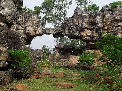
Silathoranam, a Natural arch and a distinctive geological wonder is located in Tirumala Hills at a distance of 1 km from Tirumala Venkateswara Temple. The Arch measures 8 metres in width and 3 metres in height and is eroded out of quartizite of Cuddapah Supergroup of Middle to Upper Proterozoic(1600 to 570 Ma) by weathering agents such as water and wind.[4]
Climate
Tirumala has a tropical wet and Dry climate designated Aw under the Köppen climate classification. As the hill shrine is situated amidst the hills, the temperature will go below 10 degrees in winter. Compared to Tirupati, summer won't be much here. The South-west Monsoon season starts from June, but rains won't be heavier. Occasionally, Thunderstorm forms and pours for hours. With the retreat of Southwest Monsoon in late October, North-east Monsoon brings heavy rains which cause flooding. It lasts for 2 months. Highest rainfall was recorded in 1996, with 2056 mm, 2028 mm in 2005, followed by 1829 mm in 2015 and 1708 mm in 2007. 459 mm on November 23rd, 2005 was the highest 24-hour rainfall on records, followed by 307 mm on November 9th, 2015.
| Climate data for Tirumala, India | |||||||||||||
|---|---|---|---|---|---|---|---|---|---|---|---|---|---|
| Month | Jan | Feb | Mar | Apr | May | Jun | Jul | Aug | Sep | Oct | Nov | Dec | Year |
| Average high °C (°F) | 26.0 (78.8) |
28.1 (82.6) |
30.8 (87.4) |
32.2 (90) |
35.2 (95.4) |
31.9 (89.4) |
29.9 (85.8) |
28.0 (82.4) |
27.9 (82.2) |
26.8 (80.2) |
25.2 (77.4) |
27.0 (80.6) |
29.0 (84.2) |
| Average low °C (°F) | 9.8 (49.6) |
11.9 (53.4) |
15.8 (60.4) |
19.2 (66.6) |
22.0 (71.6) |
25.3 (77.5) |
23.1 (73.6) |
24.7 (76.5) |
20.2 (68.4) |
18.7 (65.7) |
15.8 (60.4) |
12.9 (55.2) |
18.28 (64.9) |
| Record low °C (°F) | 6.9 (44.4) |
7.3 (45.1) |
10.3 (50.5) |
14.6 (58.3) |
18.1 (64.6) |
18.5 (65.3) |
17.1 (62.8) |
15.2 (59.4) |
13.5 (56.3) |
12.2 (54) |
10.6 (51.1) |
8.9 (48) |
6.9 (44.4) |
| Average precipitation mm (inches) | 25.6 (1.008) |
2.2 (0.087) |
5.3 (0.209) |
44.9 (1.768) |
59.6 (2.346) |
64.1 (2.524) |
145.5 (5.728) |
188.5 (7.421) |
209.1 (8.232) |
234.3 (9.224) |
303.5 (11.949) |
129.1 (5.083) |
1,364.5 (53.72) |
| Source: Indian Meteorological Department[5][6] | |||||||||||||
Legend
In ancient literature Tirupati is mentioned as Aadhi Varaha Kshetra. The Puranas associate the site with Lord Varaha, one of the Dashavatara of Lord Vishnu. In Varaha Purana, Venkatadri is believed to be a part of Mount Meru, which was brought on to the earth from Vishnu's abode Vaikuntam by his mount Garuda. The seven peaks represent the seven heads of Adisesha.[7]
Demographics
As of 2001 India census,[8] Tirumala has a population of 7,741. Males constitute 52 percent of the population and females 48 percent. Tirumala has an average literacy rate of 72.8 percent, higher than the national average of 59.5 percent. The male literacy rate is 57.1 percent and the female rate is 42.9 percent. In Tirumala, 11 percent of the population is under six years of age. Telugu is the major language. Hinduism is the major religion in Tirumala.[9]
Culture
Dhotis and Sarees are the traditional popular attire. The practices of tonsure and using tilaka are popular among devotees of Lord Venkateswara.
Festivals

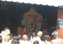
The city celebrates all major Hindu festivals including Sankranti, Ugadi etc., with great splendour. While, the Sri Venkateswara Brahmotsavams celebrated every year during October is the most important festival in Tirumala when it receives millions of devotees over a short span of a week. Vaikunta Ekadasi, the day on which it is believed that Vaikunta Dwarams will be opened and the most important Vasihnavite festival, is celebrated in Tirumala.[10] Rathasapthami is another festival, celebrated during February, when Lord Venkateswara processional deity, (Malayappa) is taken in a procession around the temple on seven different vahanas from early morning to late night.[11]
Cuisine
Tirupati is known for world-famous Tirupati Laddu. It is the prasadam at Venkateswara Temple, Tirumala. Tirupati Laddu had got Geographical indication tag which entitles only Tirumala Tirupati Devasthanams to make or sell it.[12][13]
Arts, crafts and architecture
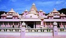
Tirumala Tirupati Devasthanams established Sri Venkateswara Museum, one at Tirumala and the other at Tirupati. It has a wonderful collection of Tirupati temple architecture and historical artefacts, such as ancient weaponry, pooja items and idols. It has a comprehensive photo gallery that gives a unique insight into the Tirupati region's culture and traditions. It also boasts a meditation centre.[14]
Landmarks

Venkateswara Temple is an abode of Lord Venkateswara situated in Tirumala. It is also known as Tirumala Temple.[15] Natural Arch is located north of the temple, which measures 8 m (26 ft) wide and 3 m (9.8 ft) high and was naturally formed from the quartz. Srivaari Paadamulu (the footprints of Lord) are believed to be the footprints of Lord Venkateswara formed when he first stood on Tirumala Hills.[16] Papavinasanam is a waterfall flowing from a tributary of the Swarnamukhi River. It also has a temple where seven lion-headed channels open from a height for deities to bathe below them. A temple dedicated to goddess Ganga is located near the enclosure. Akaasa Ganga is another natural waterfall in Tirumala.[17]
Transport
Foot Steps
There are two paths to travel on foot from Tirupati to Tirumala. These paths are called Sopanamargas. The Devotees to fulfil their Vow to Lord Venkateswara will take this path to reach Tirumala on foot from Tirupati. Both the paths are completely roofed and passes through seven hills which are part of Seshachalam Hills.[18][19]
- Alipiri Metlu – The first and Ancient path starts from Alipiri and consists of a total 3550 Steps which makes a distance of 11 km. At Alipiri there is a temple dedicated to Lord Venkateswara called Padalamandapam. There are Four Gopurams(Temple Towers) on the way.[20]
- Srivari Mettu – It originates at Srinivasa Mangapuram, about 15 kilometres (9.3 mi) from Tirupati. It is 2.1 kilometres (1.3 mi) long.[20] This trail has 2400 steps and is shorter than Alipiri Metlu path.
Road
Tirumala can be accessed by road from Alipiri. The distance is 23 kilometres (14 mi). There are two roads from Alipiri to Tirumala, one each dedicated to up and down traffic. The state government-owned Andhra Pradesh State Road Transport Corporation (APSRTC) operates frequent Saptagiri and Saptagiri Express buses from Tirupati and Alipiri and also from nearby places. Tirumala Tirupati Devasthanams (TTD) runs free buses for transit within Tirumala.
Rail
The nearest railway station is at Tirupati, about 26 kilometres (16 mi) from Tirumala. Tirupati Main is one of the major railway station in the South Central Railway zone of the Indian Railways, providing rail connectivity to major parts of India. It is under the jurisdiction of Guntakal railway division.[21] Renigunta Junction is another important railway station which lies on the Chennai – Mumbai rail corridor is 38 kilometres (24 mi) away from Tirumala.
Airport
The nearest airport is Tirupati Airport, about 40 kilometres (25 mi) from Tirumala. It is a domestic airport with direct flights to Hyderabad, Visakhapatnam and New Delhi. The nearest major airport is the Chennai International Airport, located about 162 kilometres (101 mi) from Tirumala.
See also
References
- 1 2 "District Census Handbook - Chittoor" (PDF). Census of India. p. 14,226. Retrieved 20 November 2015.
- ↑ "AP bars propagating other faiths near shrines".
- ↑ "Geological Survey of India - Monuments of Stratigraphic Significance". Archived from the original on 21 July 2011. Retrieved 22 July 2015.
- ↑ "Geological Survey of India - Monuments of Stratigraphic Significance". Retrieved 2015-07-22.
- ↑ "CLIMATOLOGICAL TABLE PERIOD: 1981–2010". Indian Meteorological Department. Retrieved 2016-01-31.
- ↑ "Archived copy" (PDF). Archived from the original (PDF) on 21 May 2013. Retrieved 29 May 2014.
- ↑ "Archived copy". Archived from the original on 19 July 2011. Retrieved 4 July 2011.
- ↑ "Census of India 2001: Data from the 2001 Census, including cities, villages and towns (Provisional)". Census Commission of India. Archived from the original on 2004-06-16. Retrieved 2008-11-01.
- ↑ "WELCOME TO CENSUS OF INDIA : Census India Library". www.censusindia.gov.in. Retrieved 2016-03-10.
- ↑ "Pilgrims throng Tirumala". Deccan Herrald. Retrieved 21 June 2015.
- ↑ "Rathasapthami photos". Archived from the original on 2009-10-27.
- ↑ "Only TTD entitled to make or sell 'Tirupati laddu': High Court". The Hindu. Retrieved 23 June 2015.
- ↑ "Now, Geographical Indication rights for 'Tirupati laddu'". Business Standard. Retrieved 23 June 2015.
- ↑ "Heritage in Tirupati-SV Museum". Andhra Pradesh Tourism board. Retrieved 23 June 2015.
- ↑ "Tirumala Temple". Archived from the original on 11 October 2007. Retrieved 13 September 2007.
- ↑ "Scratch-proof glass case to cover Srivari Padalu on Tirumala". The New Indian Express. Tirumala. 18 September 2013. Retrieved 25 March 2016.
- ↑ "Cascading waterfalls enliven Tirumala". Deccan Chronicle. Tirupati. 11 November 2015. Retrieved 25 March 2016.
- ↑ "Tirupati to Tirumala on Foot". Tirumala Tirupati Devastanams. Retrieved 2015-06-06.
- ↑ "By Walk to Tirumala Hills". Go Tirupati. Retrieved 2015-06-06.
- 1 2 "Tirupati to Tirumala on Foot". Pedestrian path (foot way) to Tirumala. Retrieved 19 December 2012.
- ↑ "Tirupati Main". Indiarailinfo. Retrieved 1 June 2015.
External links
| Wikimedia Commons has media related to Tirumala Hills. |
- Most Visited Holy Place in the World – World Record
- Vasista ashramam,Srinivasa Mangapuram,Tirupati Website
| Anantapur |   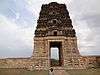  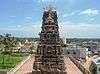 | |
|---|---|---|
| Chittoor |
| |
| East Godavari | ||
| Guntur | ||
| Kadapa | ||
| Krishna | ||
| Kurnool | ||
| Nellore | ||
| Prakasam | ||
| Srikakulam | ||
| Visakhapatnam |
| |
| Vizianagaram | ||
| West Godavari | ||