Moulsford
| Moulsford-on-Thames | |
|---|---|
 Moulsford from the River Thames | |
 Moulsford-on-Thames Moulsford-on-Thames shown within Oxfordshire | |
| Area | 7.24 km2 (2.80 sq mi) |
| Population | 526 (2001 census)[1] |
| • Density | 73/km2 (190/sq mi) |
| OS grid reference | SU585835 |
| Civil parish |
|
| District | |
| Shire county | |
| Region | |
| Country | England |
| Sovereign state | United Kingdom |
| Post town | Wallingford |
| Postcode district | OX10 |
| Dialling code | 01491 |
| Police | Thames Valley |
| Fire | Oxfordshire |
| Ambulance | South Central |
| EU Parliament | South East England |
| UK Parliament | |
| Website | Moulsford Village Website |
Moulsford is a village and civil parish and former manor in South Oxfordshire. Before 1974 it was in the county of Berkshire, in Wallingford Rural District, but following the Berkshire boundary changes of that year it became a part of Oxfordshire, in the district of South Oxfordshire. Moulsford is on the A329, by the River Thames, just north of Streatley and south of Wallingford. The west of the parish is taken up by the foothills of the Berkshire Downs, including the Moulsford Downs (a site of special scientific interest), Moulsford Bottom and Kingstanding Hill which is traditionally associated with King Alfred and the Battle of Ashdown. Like many other villages in Oxfordshire and Buckinghamshire it has been used for the filming of Midsomer Murders.
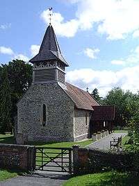
Parish church
Moulsford parish church began as a chapelry of Cholsey.[2] The first known record of the chapel dates from between 1220 and 1227.[2] The botanist and geologist John Stevens Henslow was its vicar in the 1830s. In 1846 most of the mediaeval church was demolished and the current Church of England parish church of Saint John the Baptist, designed by Sir George Gilbert Scott, was built on its foundations.[2] Scott's Gothic Revival building retains the west wall of the original church, which includes a 13th-century Early English Gothic lancet window, and the timber frame of the bellcote.[2]
Other notable buildings
- Moulsford Railway Bridge, situated just north of the village on the Great Western Main Line, designed by Isambard Kingdom Brunel and built in 1838–39.
- Fair Mile Hospital, a former lunatic asylum at Moulsford from 1870 to 2003, originally named the Moulsford Asylum.[3]
- The Beetle and Wedge public house, east of the village centre on the River Thames, on the site of a former ferry crossing.
History
Pre-Norman Conquest
The Bronze Age 'Moulsford Torc' was discovered in the parish and bought by the Museum of Reading with the aid of a grant from the Art Fund in 1961. It is a hoop-shaped decorative neck ornament, made of four spirally-twisted gold-alloy strips held together by a delicate piece of twisted gold wire.
Post Norman Conquest
Descent of the manor
In the Middle Ages until 1497 the manor of Moulsford was a principal seat of the prominent Carew family,[4] also seated at Carew Castle in Pembrokeshire and later at Mohuns Ottery in Devon. The manor of Moulsford is not listed in the Domesday Book of 1086 and is believed at that time to have been included within the royal manor of Cholsey.
References
- ↑ "Area: Moulsford CP (Parish): Parish Headcounts". Neighbourhood Statistics. Office for National Statistics. Retrieved 18 March 2010.
- 1 2 3 4 Page & Ditchfield, 1923, pages 504-507
- ↑ "Fair Mile Hospital". www.berksfhs.org.uk. UK: Berkshire Family History Society. Retrieved 22 August 2015.
- ↑ Royal Berkshire History: Moulsford Manor
Sources and further reading
- Victoria County History: A History of the County of Berkshire, Volume 3, Page, William & Ditchfield, P.H. (eds.), 1923, pp. 504–7
- Pevsner, Nikolaus (1966). The Buildings of England: Berkshire. Harmondsworth: Penguin Books. p. 179.
External links