Tadpole Bridge
| Tadpole Bridge | |
|---|---|
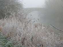 Tadpole bridge in December mist | |
| Coordinates | 51°42′08″N 1°31′00″W / 51.702248°N 1.516643°WCoordinates: 51°42′08″N 1°31′00″W / 51.702248°N 1.516643°W |
| Carries | Thames Path, Road |
| Crosses | River Thames |
| Locale | Bampton, Oxfordshire |
| Maintained by | Oxfordshire County Council |
| Characteristics | |
| Design | arch |
| Material | stone |
| Height | 14 feet 10 inches (4.52 m) |
| No. of spans | 1 |
| Load limit | 18 tonnes (18 long tons; 20 short tons) |
| History | |
| Opened | late 18th century |
Tadpole Bridge is a road bridge across the River Thames in Oxfordshire, England, carrying a road between Bampton to the north and Buckland to the south. It crosses the Thames on the reach above Shifford Lock. It is a Grade II listed building.[1]
The bridge dates from the late 18th century, the earliest reference to it being in 1784. It is built of stone, and consists of one large arch.[2]
There is a public house near Tadpole Bridge called The Trout. Thacker noted that at one time the legend over the door read "The Trout, kept by A. Herring".[2] The Trout is now a hotel and gastropub.[3]
The Thames Path crosses Tadpole Bridge.
See also
References
| Wikimedia Commons has media related to Tadpole Bridge. |
- ↑ "Tadpole Bridge and flanking walls". National Heritage List for England. Historic England. Retrieved 22 October 2017.
- 1 2 Thacker, Fred. S. (1968) [1920]. The Thames Highway: Volume II Locks and Weirs. Newton Abbot: David and Charles. p. not cited.
- ↑ The Trout at Tadpole Bridge
| Next crossing upstream | River Thames | Next crossing downstream |
| Rushey Lock (pedestrian) | Tadpole Bridge | Tenfoot Bridge (pedestrian) |
| Next crossing upstream | Thames Path | Next crossing downstream |
| southern bank Radcot Bridge |
Tadpole Bridge | northern bank Tenfoot Bridge |
This article is issued from
Wikipedia.
The text is licensed under Creative Commons - Attribution - Sharealike.
Additional terms may apply for the media files.