Teddington Lock Footbridges
| Teddington Lock Footbridge (West) | |
|---|---|
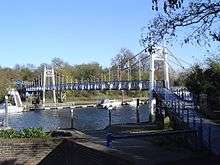 The western suspension bridge | |
| Coordinates | 51°25′53″N 0°19′26″W / 51.4315°N 0.3239°WCoordinates: 51°25′53″N 0°19′26″W / 51.4315°N 0.3239°W |
| Carries | Footpath |
| Crosses | River Thames |
| Locale | Teddington |
| Heritage status | Grade II listed structure[1] |
| Characteristics | |
| Design | Suspension |
| Material | Iron |
| History | |
| Designer | G. Pooley |
| Opened | 1889 |
| Teddington Lock Footbridge (East) | |
|---|---|
 The eastern girder bridge | |
| Coordinates | 51°25′53″N 0°19′26″W / 51.4315°N 0.3239°WCoordinates: 51°25′53″N 0°19′26″W / 51.4315°N 0.3239°W |
| Carries | Footpath |
| Crosses | River Thames |
| Locale | Ham |
| Heritage status | Grade II listed structure[1] |
| Characteristics | |
| Design | Truss bridge |
| Material | Iron |
| Height | 18 feet 4 inches (5.59 m)[2] |
| History | |
| Designer | G. Pooley |
| Opened | 1889 |
Teddington Lock Footbridge consists of two separate bridges across the River Thames in England situated just upstream of Teddington Lock at Teddington. There is a small island between the bridges.
The two footbridges were built between 1887 and 1889, funded by donations from local residents and businesses. They replaced a ferry which gave its name to Ferry Road at Teddington. The western bridge consists of a suspension bridge crossing the weir stream and linking the island to Teddington. The eastern bridge is an iron girder bridge crossing the lock cut and linking the island to Ham on the Surrey bank.
In recent years wooden ramps have been added to the approach to the bridge on the Ham side and to the middle part on the small island so that cycles and pushchairs etc. can avoid the steps up to and down from that section of the bridge.
From this point downstream the Thames Path runs on both sides of the river and upstream it runs on the Surrey side only.
The footbridges are both Grade II listed.[1]
See also
References
- 1 2 3 Historic England. "Teddington Lock Footbridges (1391392)". National Heritage List for England. Retrieved 7 July 2017.
- ↑ River Thames Alliance. Bridge heights on the River Thames. Archived 24 January 2008 at the Wayback Machine.
External links
| Next crossing upstream | River Thames | Next crossing downstream |
| Kingston Railway Bridge (railway) | Teddington Lock Footbridges | Hammerton's Ferry (pedestrian) |
| Next crossing upstream | Thames Path | Next crossing downstream |
| southern bank Kingston Bridge |
Teddington Lock Footbridges | both banks all crossings to the Thames Barrier |