Hurley, Berkshire
| Hurley | |
|---|---|
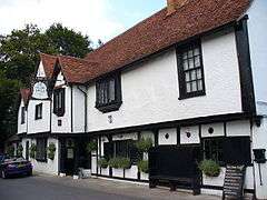 The Olde Bell inn, originally the guest house for Hurley Abbey | |
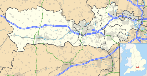 Hurley Hurley shown within Berkshire | |
| Population |
1,854 (2001) 1,923 (2011 Census)[1] |
| OS grid reference | SU826834 |
| Civil parish |
|
| Unitary authority | |
| Ceremonial county | |
| Region | |
| Country | England |
| Sovereign state | United Kingdom |
| Post town | Maidenhead |
| Postcode district | SL6 |
| Dialling code | 01628 |
| Police | Thames Valley |
| Fire | Royal Berkshire |
| Ambulance | South Central |
| EU Parliament | South East England |
| UK Parliament | |
Hurley is a small village and large, rural civil parish in Berkshire, England. Its riverside is agricultural, except for Hurley Priory, as are the outskirts of the village. The adjoining inn is believed to date to 1135.
Topography
Hurley itself is a linear development perpendicular to and adjoining the Upper Thames 4 miles (6.4 km) NW of Maidenhead and 3.5 miles (5.6 km) ENE of Henley-on-Thames, Oxfordshire on the A4130 road. The parish includes the considerable hamlets of Cockpole Green, Warren Row, Knowl Hill, Burchett's Green and part of Littlewick Green.[2]
Ashley Hill Forest, almost 2 miles (3.2 km) south of the village is close to and almost equidistant between Warren Row, Knowl Hill and Burchett's Green and is the largest woodland. Other than this the parish is mainly agricultural however many farms have spinneys of woodland adjoining.
Historic structures
- By the river is the Scheduled Ancient Monument, Hurley Priory, a partially moated Benedictine priory founded in 1086 as a cell of Westminster Abbey.[3][4] The priory was dissolved in 1536, but its priory church survives as the current parish church.
- 'The Olde Bell' Inn in Hurley is reputedly the oldest still-working inn in Britain; parts of the inn date to 1135, when it was the hostelry of Hurley Priory.[5]
- The old manor estate of Hall Place (1728) is now the home of Berkshire College of Agriculture.
- The former main priory building became a mansion known as Ladye Place, which stood adjoining the present parish church. It was the home of the Barons Lovelace. It was demolished in 1837 as uninhabitable.
- The Institute of Grassland and Environmental Research (IGER) also had a facility at Hurley until 1992.
Localities
Hurley Bottom
Only one of the buildings at the foot of the hill in the south of the village street is listed. This southerly neighbourhood has the loose name Hurley Bottom but is 10m higher than the riverside parts of the village.
Frogmore Court and Frogmore Spinney
Frogmore Spinney forms a riverside Park Homes estate, with fewer than 25 available. The court is now a farmhouse but is a centuries-old building which is listed as such adjoining the river, which in this parish consists of mainly grazing and pasture meadows.[6] Approximately seven detached or semi-detached riverside homes also adjoin the river in this western frontage point, accessed by a separate lane.[2]
Recreation
Hurley is often used as a mooring for barges and motor launches, or by campers. The weir at Hurley Lock is considered the premier venue in the United Kingdom for freestyle kayaking.
Cricket has been played in Hurley for over 100 years. The club currently plays in the Chiltern League on Saturdays and friendly fixtures against local rivals on Sundays. The ground is typified with an Old English plane tree that lies within the boundaries. The clubhouse was rebuilt in the 1970s after fire destroyed the previous wooden one.
In popular culture
- A riverside picnic scene in the James Bond film From Russia with Love was filmed near the village.
- The priory and parts of the village have been used as locations for the mystery series Midsomer Murders.
- The village is mentioned in the classic comic novel Three Men in a Boat by Jerome K. Jerome.[7]
- The setting for the short Saint story by Leslie Charteris called "The Invisible Millionaire".
Public transport
The village is served by a bus route from Maidenhead.
Closest railway stations are Marlow, Maidenhead and Henley approximately four miles north east, south east and west respectively.
Notes
- ↑ "Civil Parish population 2011". Neighbourhood Statistics. Office for National Statistics. Retrieved 30 November 2016.
- 1 2 Grid square map Ordnance survey website
- ↑ "The Priory of Hurley". British History Online. Retrieved 24 November 2012.
- ↑ Historic England. "Details from listed building database (1007933)". National Heritage List for England. Retrieved 18 June 2013.
- ↑ "The Olde Bell". (official website). Retrieved 24 November 2012.
- ↑ Frogmore Farmhouse Historic England. "Details from listed building database (1319393)". National Heritage List for England. Retrieved 18 June 2013.
- ↑ https://ebooks.adelaide.edu.au/j/jerome/jerome_k/three/chapter13.html
External links
| Wikimedia Commons has media related to Hurley, Berkshire. |