Thames Head
Coordinates: 51°41′39″N 2°01′47″W / 51.694262°N 2.029724°W
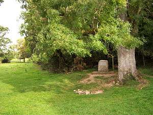
Thames Head is the site in Gloucestershire, traditionally identified as the source of the River Thames, a major river which runs through the centre of London. It is in a meadow known as Trewsbury Mead near the village of Kemble[1] and the town of Cirencester. The elevation of the source is 360 feet (110 m) above sea level.
The claim that this site is the source of the River Thames is disputed. The Environment Agency, the Ordnance Survey and other authorities have the source of the Thames as Trewsbury Mead. Others hold that the true source of the Thames is at Seven Springs, Gloucestershire, some 11 miles (18 km) farther north, and east of Gloucester. Seven Springs is officially the source of the River Churn, which is a tributary of the Thames that joins at Cricklade. As it is further from the mouth of the Thames than Trewsbury Mead, the adoption of Seven Springs as its source would make the Thames the longest river in the UK.[2][3]
Monument
A monument beneath an ash tree bears the inscription:
THE CONSERVATORS OF THE RIVER THAMES
1857-1974
THIS STONE WAS PLACED HERE TO MARK THE
SOURCE OF THE RIVER THAMES
A nearby basin of stones marks the spring. However, there is usually only water during a wet winter.
References
| Wikimedia Commons has media related to Thames Head. |
- ↑ Thames Pathway Ch1, Accessed 15 August 2015
- ↑ BBC News, Gloucestershire. 15 May 2012 Could the River Thames be longer than the River Severn? by David Bailey
- ↑ Dorothy Hart (9 May 2004). "Seven Springs and the Churn". The-river-thames.co.uk. Retrieved 17 May 2010.