Formartine and Buchan Way
| Formatine and Buchan Way | |
|---|---|
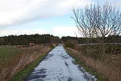 Formatine and Buchan Way at Logierieve. | |
| Length | 64 km (40 mi) to Fraserburgh, plus 21 km (13 mi) spur to Peterhead.[1] |
| Location | Aberdeenshire, Scotland |
| Designation | Scotland's Great Trails |
| Trailheads | |
| Use | Walking, cycling, horseriding[2] |
| Elevation | |
| Elevation gain/loss | 420 metres (1,380 ft) gain[3] |
| Hiking details | |
| Season | All Year |
| Website | https://www.aberdeenshire.gov.uk/paths-and-outdoor-access/long-distance-routes/formartine-and-buchan-way/ |

The Formartine and Buchan Way is a long-distance footpath in Scotland, extending from Dyce north to Peterhead and Fraserburgh in the Buchan and Formartine districts of Aberdeenshire in Scotland. It follows the track of a former railway line, the Formartine and Buchan Railway, and is open to walkers, cyclists and horse riders.[2] The railway closed in 1979 (Fraserburgh) and 1970 (Maud-Peterhead). The walkway opened in the early 1990s, and is managed by Aberdeenshire Council.[4] It is listed as one of Scotland's Great Trails by Scottish Natural Heritage.[3] Places of interest along the way include Drinnes Wood Observatory, Strichen Stone Circle, Aden Country Park, Deer Abbey and The White Horse at Strichen.
The total path is around 85 kilometres (53 mi) long if both spurs are walked and can be accessed relatively easily by public transport or car.[2] An information pack detailing the route has been produced by Aberdeenshire Council: the pack can be purchased from local tourist information centres and is also available to download.[5] The route is also marked on OS maps. The path is well signposted and is easy to follow. The track is relatively flat and undulates only when roads have to be crossed. It is well maintained, and few parts are overgrown. However, the Maud to Strichen section has a detour because of overgrown shrubbery, marshy conditions and numerous problems such as gates and fences blocking access.
Sections
| Start point | End point | Length[6] | Notes | |
|---|---|---|---|---|
| km | mi | |||
| Dyce | Udny Station | 13 | 8.1 | |
| Udny Station | Ellon | 8 | 5.0 | |
| Ellon | Auchnagatt | 12 | 7.5 | |
| Auchnagatt | Maud | 7 | 4.3 | |
| Maud | Strichen | 9 | 5.6 | |
| Strichen | Fraserburgh | 17.5 | 10.9 | |
| Dyce | Fraserburgh | 64 | 40 | Total excluding Peterhead branch[1] |
| Maud | Longside | 11.5 | 7.1 | Peterhead branch |
| Longside | Peterhead | 10.5 | 6.5 | Peterhead branch |
| Maud | Fraserburgh | 21 | 13 | Total for Peterhead branch[1] |
| Complete route[1] | 85 | 53 | ||
History of the route
The 29-mile (47 km) long railway from Dyce to Mintlaw railway station opened on 18 July 1861, with the 13-mile (21 km) section from Maud to Peterhead railway station opening the following year. A 15-mile (24 km) long section north to Fraserburgh railway station opened on 24 April 1865.[7] Passenger services were withdrawn by the Scottish Region of British Railways in 1965 as part of the Beeching cuts. Freight trains continued to operate to Peterhead until 1970 and Fraserburgh until 1979. This was in spite of the fact a considerable amount of freight traffic was being generated by the off shore oil and gas industry. Conversion of the line to a footpath and cycleway started in 1987, and was led by the Buchan Countryside Group.[6]
References
- 1 2 3 4 "Formartine and Buchan Way - Route Cards". Aberdeenshire Council. Retrieved 2018-08-29.
- 1 2 3 "Formatine and Buchan Way". Scotland's Great Trails. Retrieved 2018-08-22.
- 1 2 "Trails". Scotland's Great Trails. Retrieved 2018-08-22.
- ↑ "SNH Commissioned Report 380: Developing the network of longer distance routes" (PDF). Scottish Natural Heritage. 2010. p. 19. Retrieved 2018-08-08.
- ↑ "Formartine and Buchan Way". Aberdeenshire Council. Retrieved 2018-08-29.
- 1 2 "Formatine and Buchan Way". WalkHighlands. Retrieved 2018-08-29.
- ↑ Awdry, Christopher (1990). Encyclopaedia of British Railway Companies. Sparkford: Patrick Stephens Ltd. ISBN 1-8526-0049-7. OCLC 19514063. CN 8983. , (1990). p.132
See also
External links
| Wikimedia Commons has media related to Formartine and Buchan Way. |
- Official Website from Aberdeenshire Council
- Formartine and Buchan Way guide and mapping on Walkhighlands
- Information about the former railway
Settlements and places of interest in Buchan, Aberdeenshire | ||
|---|---|---|
| Primary settlements |  | |
| Other settlements | ||
| Places of interest | ||
Settlements and places of interest in Formartine, Aberdeenshire | ||
|---|---|---|
| Primary settlements | 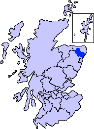 | |
| Other settlements | ||
| Places of interest | ||