Forest Avenue (BMT Myrtle Avenue Line)
Forest Avenue | |||||||
|---|---|---|---|---|---|---|---|
|
| |||||||
 | |||||||
| Station statistics | |||||||
| Address |
Forest Avenue & Putnam Avenue Queens, NY 11385 | ||||||
| Borough | Queens | ||||||
| Locale | Ridgewood | ||||||
| Coordinates | 40°42′17″N 73°54′07″W / 40.704619°N 73.901982°WCoordinates: 40°42′17″N 73°54′07″W / 40.704619°N 73.901982°W | ||||||
| Division | B (BMT) | ||||||
| Line | BMT Myrtle Avenue Line | ||||||
| Services |
M | ||||||
| Transit connections |
| ||||||
| Structure | Elevated | ||||||
| Platforms | 1 island platform | ||||||
| Tracks | 2 | ||||||
| Other information | |||||||
| Opened | August 9, 1915 | ||||||
| Closed | July 1, 2017 (temporary line closure) | ||||||
| Reopened | September 1, 2017 | ||||||
| Station code | 110[1] | ||||||
| Traffic | |||||||
| Passengers (2017) |
796,742[2] | ||||||
| Rank | 381 out of 425 | ||||||
| Station succession | |||||||
| Next east |
Fresh Pond Road: M | ||||||
| Next west |
Seneca Avenue: M | ||||||
| |||||||
| |||||||
| |||||||


Forest Avenue is a station on the BMT Myrtle Avenue Line of the New York City Subway. The station is served by the M train at all times.
Station layout
| P Platform level |
Westbound | ← Myrtle Avenue nights (Seneca Avenue) |
| Island platform, doors will open on the left | ||
| Eastbound | | |
| M | Mezzanine | Fare control, station agent, MetroCard machines |
| G | Street level | Exit/entrance |
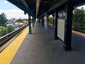
Forest Avenue has two tracks and an island platform. The canopy is metal while the mezzanine under the station is wood.
Forest Avenue Station was originally built in 1915 by the Brooklyn Rapid Transit Company, along with two other nearby stations. The Myrtle Avenue Elevated line was already extended to Middle Village nine years earlier. The station was acquired by Brooklyn Manhattan Transit Company in 1923, and later by the New York City Board of Transportation in 1940.
Exits
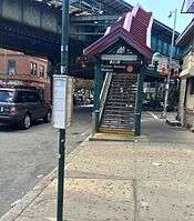
The only open exit is at the east end of the station. Stairs from the platform lead down to a mezzanine below the tracks, from which two stairs lead to the western side of Forest Avenue on opposite sides of the intersection of Fairview and Putnam Avenues.[3] There was also an exit at the west end that led to Woodward Avenue.
References
- ↑ "Station Developers' Information". Metropolitan Transportation Authority. Retrieved June 13, 2017.
- ↑ "Facts and Figures: Annual Subway Ridership 2012–2017". Metropolitan Transportation Authority. July 12, 2018. Retrieved July 12, 2018.
- ↑ "MTA Neighborhood Maps: Ridgewood" (PDF). mta.info. Metropolitan Transportation Authority. 2015. Retrieved 20 July 2016.
External links
- nycsubway.org – BMT Myrtle Avenue Line: Seneca Avenue
- Station Reporter — M Train
- The Subway Nut — Forest Avenue Pictures
- Putnam Avenue entrance (near Forest Avenue) from Google Maps Street View
- Platform from Google Maps Street View
| Myrtle Ave. Line | |
|---|---|
| |