Stamford Hill, Durban
| Stamford Hill | |
|---|---|
 Stamford Hill in foreground, flanking the M12 route, with Durban Central beyond | |
 Stamford Hill | |
|
Location within Durban 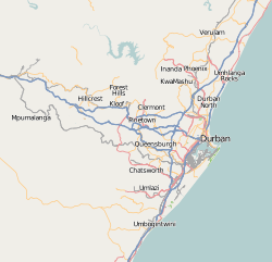 Stamford Hill  Stamford Hill Stamford Hill (South Africa)  Stamford Hill Stamford Hill (Africa) | |
| Coordinates: 29°49′41″S 31°01′52″E / 29.828°S 31.031°ECoordinates: 29°49′41″S 31°01′52″E / 29.828°S 31.031°E | |
| Country | South Africa |
| Province | KwaZulu-Natal |
| Municipality | eThekwini |
| Main Place | Durban |
| Area[1] | |
| • Total | 6.09 km2 (2.35 sq mi) |
| Population (2011)[1] | |
| • Total | 2,585 |
| • Density | 420/km2 (1,100/sq mi) |
| Racial makeup (2011)[1] | |
| • Black African | 96.5% |
| • Coloured | 0.9% |
| • Indian/Asian | 1.4% |
| • White | 1.1% |
| • Other | 0.1% |
| First languages (2011)[1] | |
| • Zulu | 58.4% |
| • English | 13.2% |
| • Xhosa | 9.7% |
| • Afrikaans | 1.3% |
| • Other | 17.3% |
| Time zone | UTC+2 (SAST) |
| Postal code (street) | 4001 |
| PO box | 4025 |
Stamford Hill is a suburb of Durban, KwaZulu-Natal, South Africa. It is administered by the eThekwini Metropolitan Municipality and its postal code is 4001.
The suburb, located on the Indian Ocean coast, is non-residential and consists primarily of non-public open space. The Kings Park Sporting Precinct is home to the Moses Mabhida Stadium which opened in 2009 and is a venue for the 2010 FIFA World Cup, as well as a range of other sporting venues and facilities. North of the precinct is the Windsor Mashie Golf Course and the Durban Country Club. The southern section of the suburb, on the coast at Battery Beach, is home to Water World and the Suncoast Casino and Entertainment World.
Gallery

 Buildings of the Durban Country Club
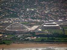 Kings Park Stadium right, in 2009, and the Moses Mabhida Stadium still under construction
References
- 1 2 3 4 "Sub Place Stamford Hill". Census 2011.
- MapStudio (2005). Street Guide - Durban (8th Edition). p. Map 56. ISBN 1-86809-739-0.
.svg.png)
This article is issued from
Wikipedia.
The text is licensed under Creative Commons - Attribution - Sharealike.
Additional terms may apply for the media files.