Clermont, KwaZulu-Natal
| Clermont | |
|---|---|
 Clermont | |
|
Location within Durban 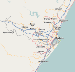 Clermont  Clermont Clermont (South Africa)  Clermont Clermont (Africa) | |
| Coordinates: 29°47′00″S 30°54′00″E / 29.78333°S 30.9°ECoordinates: 29°47′00″S 30°54′00″E / 29.78333°S 30.9°E | |
| Country | South Africa |
| Province | KwaZulu-Natal |
| Municipality | eThekwini |
| Area[1] | |
| • Total | 6.94 km2 (2.68 sq mi) |
| Population (2011)[1] | |
| • Total | 52,075 |
| • Density | 7,500/km2 (19,000/sq mi) |
| Racial makeup (2011)[1] | |
| • Black African | 99.5% |
| • Coloured | 0.1% |
| • Indian/Asian | 0.1% |
| • Other | 0.2% |
| First languages (2011)[1] | |
| • Zulu | 68.8% |
| • Xhosa | 20.3% |
| • Sotho | 5.2% |
| • English | 1.7% |
| • Other | 4.0% |
| Time zone | UTC+2 (SAST) |
| Postal code (street) | 3610 |
Clermont is a township of Durban in KwaZulu-Natal, South Africa.
Clermont under the apartheid days was a black middle income township. It is surrounded by Westville, Kloof, Westville and Inanda in the distant. Its main road is called Clermont road and is named after Sir Clermont, a farmer who sold his land. It was the only place in Durban where black people were able to buy property and build houses. Since the end of apartheid Clermont has been sprawling with shacks as people from the rural areas come and seek work opportunities in the nearby suburbs of Westville and New Germany, Pinetown and Durban.
Clermnont has a large Anglican, Catholic and Wesleyan Church community and on Sundays one can see the women of each denomination wearing their church uniforms with pride.
References
- Municipal Demarcation Board
- Community Justice in a Volatile South Africa: Containing Community Conflict, Clermont, Natal by Daniel Nina (Social Justice 20 (3-4) (Fall-Winter 1993): 129-42)
- 1 2 3 4 "Main Place Clermont". Census 2011.
External links
- eThekwini Online The official site of Durban, South Africa
.svg.png)