Bluff, KwaZulu-Natal
| Bluff | |
|---|---|
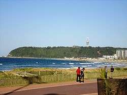 The Bluff as seen from Greens Walk, Durban | |
 Bluff | |
|
Location within Durban 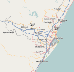 Bluff  Bluff Bluff (South Africa)  Bluff Bluff (Africa) | |
| Coordinates: 29°55′29″S 31°0′14″E / 29.92472°S 31.00389°ECoordinates: 29°55′29″S 31°0′14″E / 29.92472°S 31.00389°E | |
| Country | South Africa |
| Province | KwaZulu-Natal |
| Municipality | eThekwini |
| Area[1] | |
| • Total | 21.68 km2 (8.37 sq mi) |
| Population (2011)[1] | |
| • Total | 68,124 |
| • Density | 3,100/km2 (8,100/sq mi) |
| Racial makeup (2011)[1] | |
| • Black African | 15.6% |
| • Coloured | 36.6% |
| • Indian/Asian | 30.1% |
| • White | 17.1% |
| • Other | 0.6% |
| First languages (2011)[1] | |
| • English | 79.8% |
| • Zulu | 8.1% |
| • Afrikaans | 7.2% |
| • Xhosa | 1.7% |
| • Other | 3.3% |
| Time zone | UTC+2 (SAST) |
| Postal code (street) | 4052 |
| PO box | 4036 |
Bluff or The Bluff is a geographical area, containing seven suburbs in Durban, eThekwini Metropolitan Municipality, KwaZulu-Natal Province, South Africa. Within the area referred to as "The Bluff" lie the suburbs of Brighton Beach, Grosvenor, King's Rest, Ocean View, Fynnland, Treasure Beach and Wentworth. The name of the area is derived from the long bluff - two ancient sand dunes on which most of the suburbs lie. The Bluff is one of the main enclosing elements of Durban Harbour from the Indian Ocean, and forms the southern quayside of the Port of Durban.[2]
History
The promontory on which Bluff is situated is Durban's most prominent natural landmark. Accordingly, it probably served as an important visual reference for navigational approaches into Durban Harbour.[3]
Between 1907 and 1975, the exposed south-east side of The Bluff housed a whaling station. Since the mid-Nineteenth Century, the region has been purposed for navigational and military uses. This use has provided protection for much of the area's native vegetation. Today, the area is considered important in the ecological management of Durban and environment.[3]
The traditional Zulu name for Bluff is isibubulungu, meaning a long, round-shaped ridge. It also means "white man’s bluff", which may be a reference to habitation by shipwreck survivors.[3] The Bluff promonotory is a remnant of an extensive coastal dune system that formed along the shoreline of KwaZulu-Natal between two and five million years ago.[3]
Features
The Bluff is a popular holiday destination, with extensive accommodation and plentiful seaside recreation. The area is known for its abundant sea life, including dolphins, and, in the winter months, whales.[2]
There are two main beaches: Brighton Beach and Anstey's, while a smaller, lesser-known beach to the north is Garvie's. There is golf course and a wetland area with a large population of various bird species.
At the south end of the Bluff is the South Durban Basin (as the area is known); there are five main residential suburbs: Austerville, Merebank, Merewent, Stanvac and Treasure Beach. Interspersed among the houses are a number of industries, including two of South Africa’s largest oil refineries (Sapref and Engen facilities), the Mondi paper mill and other smaller factories. Durban's main airport was nearby until 2010. Durban International Airport moved and changed its name on May 1, 2010, relocating from the South Durban Basin to near Ballito, on the North Coast.
The mixture of residential homes and large industries in the basin creates a challenge for all those who live and work in the area. Air pollution, water pollution, overcrowding and litter are some of the problems that residents and industries need to resolve.
References
- 1 2 3 4 "Sub Place Bluff". Census 2011.
- 1 2 "Bluff, Durban Information". WhereToStay. Retrieved 9 March 2010.
- 1 2 3 4 "Durban South Tourism Route". Open Africa. Archived from the original on 27 September 2010. Retrieved 9 March 2010.
External links
| Wikimedia Commons has media related to The Bluff. |
- eThekwini Online Accessed 9 March 2010
- KwaZulu-Natal Tourism Authority Accessed 9 March 2010
- KwaZulu-Natal search engine Accessed 9 March 2010
.svg.png)