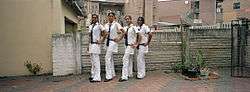
Chatsworth, KwaZulu-Natal
| Chatsworth umhlatuzana township | |
|---|---|
 | |
 Chatsworth | |
|
Location within Durban 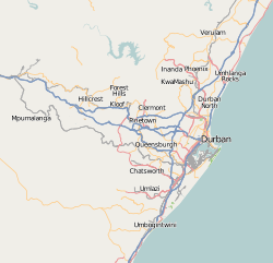 Chatsworth  Chatsworth Chatsworth (South Africa)  Chatsworth Chatsworth (Africa) | |
| Coordinates: 29°54′36″S 30°53′06″E / 29.910°S 30.885°ECoordinates: 29°54′36″S 30°53′06″E / 29.910°S 30.885°E | |
| Country | South Africa |
| Province | KwaZulu-Natal |
| Municipality | eThekwini |
| Government | |
| Area[1] | |
| • Total | 42.73 km2 (16.50 sq mi) |
| Population (2011)[1] | |
| • Total | 196,580 |
| • Density | 4,600/km2 (12,000/sq mi) |
| Racial makeup (2011)[1] | |
| • Black African | 38.2% |
| • Coloured | 1.2% |
| • Indian/Asian | 60.0% |
| • White | 0.1% |
| • Other | 0.5% |
| First languages (2011)[1] | |
| • English | 62.6% |
| • Zulu | 26.2% |
| • Xhosa | 5.7% |
| • Sotho | 1.3% |
| • Other | 4.2% |
| Time zone | UTC+2 (SAST) |
| Postal code (street) | 4092 |
| PO box | 4030 |
| Area code | 031 |
| Website | www.durban.gov.za |
Chatsworth is a large formerly Indian township created by the apartheid government in the 1950s to segregate the predominantly Indian population and create a buffer between the white suburbs to the north and the black townships to the south. The township is situated in South Durban basin in South Africa and is roughly bordered by the Umhlatuzana River in the North and Umlaas River in the South. The township today is undergoing a rapid integration of blacks and Indians.
History
In the 1940s, the Pegging Acts and the Asiatic Land Tenure and Indian Representation Act, 1946 were passed. These acts gave the government the right to remove and destroy shacks and small self-made shelters, with the putative intention of improving sanitary conditions. This led to the Group Areas Act of June 1950, in which certain residential areas were designated for Whites, Indians, Coloureds, and Africans only. Indians were removed from areas such as Mayville, Cato Manor, the Clairwood, Magazine Barracks, Bluff, Riverside, Prospect Hall, Duikerfontein, and Sea Cow Lake. They were forcibly moved into the two townships of Phoenix, which is situated North of Durban, and Chatsworth in the South.
During the late 1940s and early 1950s, there were advertisements in papers for an exclusively Indian town, Umhlatuzana. This progressed into the greater Chatsworth District in the early 1960s when planning commenced and official movements took place in 1964 to the eleven units: Unit 1, 2, 3, 5, 6, 7, 9, 10, and Unit 11. Modern day Chatsworth is spread over seven municipal wards which all fall roughly in the South Central municipal area. The intentional buffer design of Chatsworth creates today an interesting melting pot of people frequenting Chatsworth's business district which comprises a bustling center, The Chatsworth Center.
The crime rate has seen a drastic increase, however, due to lack of resources to the youth and South Africa's worrisome unemployment level. The township has a noticeable issue with drug use amongst youngsters. Several efforts are organized by the community to combat the drug use but further interventions are needed from provincial and state level.
Education
South Africa's Indian population, culturally has placed an emphasis on education during times when Apartheid Laws prevented intellectual and material development of non-white races, believing only whites were capable of inquiry of the mathematic and scientific fields. As a result of resistance, the Indian population has excelled academically and have produced many academics who are former inhabitants of Chatsworth. Most secondary schools in Chatsworth boast pass rates above 90 per cent for the Matric Examinations despite lacking resources and facilities. Kharwastan Secondary School and Wingen Heights Secondary School regularly produce learners that are placed in the provincial Top 30.
Public Secondary Schools
- Apollo Secondary School,[2] Collier Avenue, Umhlatuzana Township
- Arena Park Secondary School,[3] Rose Heights Drive, Arena Park
- Asoka Secondary School, Skyridge Circle, Moorton
- Brindhaven Secondary School, Road No 706, Montford
- Chatsworth Secondary School,[4] Lenny Naidu Drive (Pelican Drive), Bayview
- Crossmoor Secondary School,[5] Golden Poppy Crescent, Crossmoor
- Glenover Secondary School, Glenover Rd, Westcliff
- Kharwastan Secondary School,[6] Iris Avenue, Kharwastan
- Marklands Secondary School, Himalaya Drive, Shallcross
- Meadowlands School of Technology,[7] Road 734, Montford
- Montarena Secondary School, Road 706, Montford
- Newhaven Secondary School,[8] Croftdene Road, Croftdene
- Protea Secondary School, Road 257, Bayview
- Risecliff Secondary School,[9] Blue Jill Crescent, Risecliff
- Shallcross Secondary School, Alpine Drive, Shallcross
- Southlands Secondary School,[10] Havenside Drive, Havenside
- Welbedene Secondary School,[11] Road 749, Montford
- Westcliff Secondary School, Florence Nightingale Drive, Westcliff
- Wingen Heights Secondary School,[12] Wingen Walk, Shallcross
- Witteklip Secondary School,[13] Witteklip Street, Croftdene
- Woodhurst Secondary School, Woodhurst Drive, Woodhurst
Current situation
Indian people in Chatsworth are from various religious groups. Many masjids, temples, and churches are present. One of many famous masjids is Habibia Manzil in Shallcross. As a consequence of its history, Chatsworth still has a predominantly Indian population. It is a centre of Indian culture, and holds the Temple of Understanding—a Hindu temple. Many Indians from Tamil and Telugu backgrounds are present. Such Indian languages are still spoken at home in many instances, with learning classes set up to aid in their development.
This area is now a fully fledged post apartheid suburb of the Durban Ethekwini Municipality with industrial developments and infrastructure that continues to contribute to the growing intellectual capital and business environment of Durban.
See also
References
- 1 2 3 4 "Main Place Chatsworth". Census 2011.
- ↑ http://www.looklocal.co.za/looklocal/content/en/chatsworth/chatsworth-secondary-schools?oid=4565937&sn=Detail&pid=1171685&urlField=Apollo%20Secondary%20School
- ↑ Local News Network. "Latest News - Free Advertising - Business Directory - Look Local".
- ↑ Local News Network. "Latest News - Free Advertising - Business Directory - Look Local".
- ↑ Crossmoor Secondary School. "education, kwazulu natal schools, chatsworth, maths, science, geography, ma - Chatsworth, Durban - crossmoor secondary school". crossmoor secondary school.
- ↑ Local News Network. "Latest News - Free Advertising - Business Directory - Look Local".
- ↑ http://msot.co.za/
- ↑ Local News Network. "Latest News - Free Advertising - Business Directory - Look Local".
- ↑ Local News Network. "Latest News - Free Advertising - Business Directory - Look Local".
- ↑ Pro Media Mogul. "Southlands Secondary School - Tel : 031 4003033 Email : info@southlands.co.za".
- ↑ Local News Network. "Latest News - Free Advertising - Business Directory - Look Local".
- ↑ Payghost Websites. "Wingen Heights Secondary Shallcross Chatsworth Durban".
- ↑ Local News Network. "Latest News - Free Advertising - Business Directory - Look Local".
.svg.png)