Mpumalanga, KwaZulu-Natal
| Mpumalanga | |
|---|---|
 Mpumalanga | |
|
Location within Durban 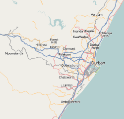 Mpumalanga  Mpumalanga Mpumalanga (South Africa)  Mpumalanga Mpumalanga (Africa) | |
| Coordinates: 29°49′01″S 30°38′13″E / 29.817°S 30.637°ECoordinates: 29°49′01″S 30°38′13″E / 29.817°S 30.637°E | |
| Country | South Africa |
| Province | KwaZulu-Natal |
| Municipality | eThekwini |
| Area[1] | |
| • Total | 21.66 km2 (8.36 sq mi) |
| Population (2011)[1] | |
| • Total | 62,406 |
| • Density | 2,900/km2 (7,500/sq mi) |
| Racial makeup (2011)[1] | |
| • Black African | 99.5% |
| • Coloured | 0.2% |
| • Indian/Asian | 0.2% |
| • White | 0.1% |
| • Other | 0.1% |
| First languages (2011)[1] | |
| • Zulu | 92.5% |
| • English | 2.3% |
| • S. Ndebele | 1.3% |
| • Other | 3.8% |
| Time zone | UTC+2 (SAST) |
| Postal code (street) | 3701 |
| PO box | 3699 |
| Area code | 031 |
Mpumalanga is a town in eThekwini in the KwaZulu-Natal province of South Africa. It is a township about 10 km south-south-east of Cato Ridge and some 40 km west of Durban. Derived from Zulu, the name means 'sunrise', 'the sun comes out'.[2]
References
- 1 2 3 4 "Main Place Mpumalanga". Census 2011.
- ↑ "Dictionary of Southern African Place Names (Public Domain)". Human Science Research Council. p. 320.
| Authority control |
|---|
This article is issued from
Wikipedia.
The text is licensed under Creative Commons - Attribution - Sharealike.
Additional terms may apply for the media files.