Big Rock Township, Kane County, Illinois
| Big Rock Township | |
|---|---|
| Township | |
 | |
 Location in Kane County | |
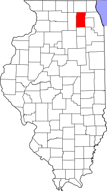 Kane County's location in Illinois | |
| Coordinates: 41°45′49″N 088°32′48″W / 41.76361°N 88.54667°WCoordinates: 41°45′49″N 088°32′48″W / 41.76361°N 88.54667°W | |
| Country | United States |
| State | Illinois |
| County | Kane |
| Established | November 6, 1849 |
| Area | |
| • Total | 35.11 sq mi (90.9 km2) |
| • Land | 35.11 sq mi (90.9 km2) |
| • Water | 0 sq mi (0 km2) 0% |
| Elevation[1] | 709 ft (216 m) |
| Population (2010) | |
| • Estimate (2016)[2] | 1,887 |
| • Density | 52.9/sq mi (20.4/km2) |
| FIPS code | 17-089-05989 |
| GNIS feature ID | 0428673 |
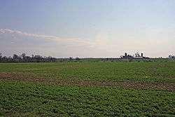
Big Rock Township is located in Kane County, Illinois. As of the 2010 census, its population was 1,859 and it contained 717 housing units.[3] Most of its land use is agricultural.
Geography
According to the 2010 census, the township has a total area of 35.11 square miles (90.9 km2), all land.[3]
U.S. Route 30 runs east to west through the township.
Cities and towns
Demographics
| Historical population | |||
|---|---|---|---|
| Census | Pop. | %± | |
| Est. 2016 | 1,887 | [2] | |
| U.S. Decennial Census[4] | |||
Images
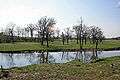 Big Rock Creek
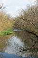 Big Rock Creek
Notes
- ↑ "US Board on Geographic Names". United States Geological Survey. 2007-10-25. Retrieved 2008-01-31.
- 1 2 "Population and Housing Unit Estimates". Retrieved June 9, 2017.
- 1 2 "Population, Housing Units, Area, and Density: 2010 - County -- County Subdivision and Place -- 2010 Census Summary File 1". United States Census. Retrieved 2013-05-28.
- ↑ "Census of Population and Housing". Census.gov. Retrieved June 4, 2016.
References
- "Big Rock Township, Kane County, Illinois". Geographic Names Information System. United States Geological Survey. Retrieved 2010-01-17.
- Illinois Regional Archives Depository System. "Name Index to Illinois Local Governments". Illinois State Archives. Illinois Secretary of State.
External links
- Big Rock Township Assessor
- Official Village of Big Rock website
- Big Rock Forest Preserve
- Big Rock Park District
- Hinckley-Big Rock CUSD 429
Municipalities and communities of Kane County, Illinois, United States | ||
|---|---|---|
| Cities | ||
| Villages | ||
| Townships | ||
| CDP | ||
| Other unincorporated communities |
| |
| Footnotes | ‡This populated place also has portions in an adjacent county or counties | |
This article is issued from
Wikipedia.
The text is licensed under Creative Commons - Attribution - Sharealike.
Additional terms may apply for the media files.