Sperrins
| The Sperrins | |
|---|---|
|
Na Speiríní (Irish)[1] Sperrin Muntains (Ulster-Scots)[2] | |
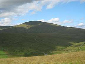 Sawel Mountain, the highest point of the Sperrins | |
| Highest point | |
| Peak | Sawel Mountain |
| Elevation | 678 m (2,224 ft) |
| Geography | |
| Sovereign state | United Kingdom |
| Constituent country | Northern Ireland |
| Counties | County Tyrone, County Londonderry |
| Range coordinates | 54°48′00″N 7°04′59″W / 54.8°N 7.083°WCoordinates: 54°48′00″N 7°04′59″W / 54.8°N 7.083°W |
| Geology | |
| Orogeny | Caledonian orogeny |
| Type of rock | Schist, quartzite,[3] granite, basalt, rhyolite |
The Sperrins or Sperrin Mountains (from Irish Speirín, meaning 'little pinnacle'[4]) are a range of mountains in Northern Ireland and one of the largest upland areas in Ireland. The range stretches the counties of Tyrone and Londonderry from south of Strabane eastwards to Slieve Gallion in Desertmartin and north towards Limavady. The region has a population of some 150,000 and is a designated Area of Outstanding Natural Beauty.
Features
It has a distinctive glaciated landscape. The Glenshane Pass, part of the A6 Belfast to Derry road, is in the mountains and has notoriously bad weather in winter. Sawel Mountain is the highest peak in the Sperrins, and the seventh highest in Northern Ireland. Its summit rises to 678 m (2,224 ft). Another of the Sperrins, Carntogher (464 m), towers over the Glenshane Pass.[5]
Geologically, the Sperrins are formed mostly from Precambrian metamorphic rocks, with some younger Ordovician igneous rocks in the southern flank of the range.
See also

References
- ↑ Hoare, Natalie (July 2009) UK Landscapes, The Sperrins, Geographical Magazine
- ↑ "Ulstèr Merikay Fowk Pairk, Youngstèrs Wisin". National Museums Northern Ireland. Archived from the original on 11 October 2013. Retrieved 19 July 2017.
- ↑ The Rock Cycle, Schist, Co Tyrone, The Geological Society
- ↑ Ulster Place Names - Magherafelt (C. Dunbar)
- ↑ "Glenshane Slopes Landscape". Environment and Heritage Service. Archived from the original on 2012-07-31. Retrieved 2008-06-26.
External links
- Landscapes Unlocked - Aerial footage from the BBC Sky High series explaining the physical, social and economic geography of Northern Ireland.
Mountains and hills of Ulster | ||
|---|---|---|
| Antrim Hills | 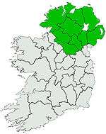 | |
| Antrim Plateau | ||
| Belfast Hills | ||
| Breifne | ||
| Croaghgorms | ||
| Derryveagh | ||
| Inishowen | ||
| Mournes | ||
| Sperrins | ||
| Southwest Donegal | ||
| Others | ||
