Fivemiletown
Fivemiletown
| |
|---|---|
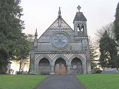 The Catholic church | |
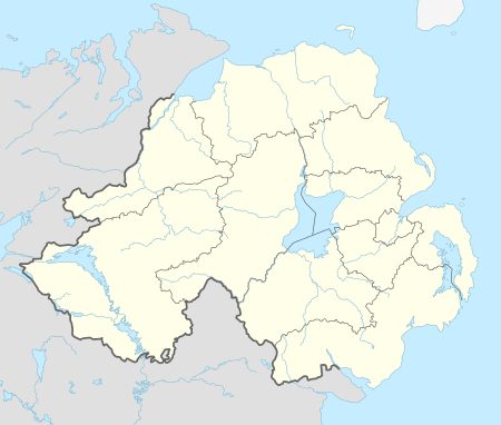 Fivemiletown shown within Northern Ireland | |
| Population | 1,356 (2008 estimate) |
| Irish grid reference | H445478 |
| • Belfast | 64 miles (103 km) |
| District | |
| County | |
| Country | Northern Ireland |
| Sovereign state | United Kingdom |
| Post town | FIVEMILETOWN |
| Postcode district | BT75 |
| Dialling code | 028 |
| EU Parliament | Northern Ireland |
| UK Parliament | |
| NI Assembly | |
Fivemiletown, known before the Plantation of Ulster as Ballylurgan[1] (from Irish Baile na Lorgan, meaning 'settlement of the long ridge'), is a village and townland in County Tyrone, Northern Ireland. It is 16 miles (26 km) east of Enniskillen and 26 miles (43 km) west-south-west of Dungannon, on the A4 Enniskillen-to-Dungannon road.[2]
Its population as of 2008 is estimated to be 1,356. The village is most famous for its creamery, which was begun as a cooperative in 1898 by Hugh de Fellonburg Montgomery. Fivemiletown Creamery originally made butter and milk, but now makes cheeses for the Irish market and for export across Europe and North America.[3]
Name
Fivemiletown's English language name comes from its location five Irish miles (1 Irish mile = 1.27 statute miles = 2044 m) from its nearest neighbours: Clogher, Brookeborough and Tempo.
History
The Clogher Valley Railway ran from Tynan, County Armagh, to Maguiresbridge, County Fermanagh, with Fivemiletown being one of its main stations. The old station house is still one of the landmarks in the village. The trains stopped at the Buttermarket on Main Street and the creamery to be loaded or unloaded with goods.
After the Second World War, the growth of road transport made railways almost redundant and when the Northern Ireland Government learned that the Clogher Valley Railway had operated as a loss for 27 years because of growing road transport, it recommended the shutting of the line. The last train ran on the last day of 1941, bringing to an end one of Fivemiletown's most characteristic features.
The Troubles
Incidents in Fivemiletown during the Troubles resulting in two or more deaths: 1993
- 12 December 1993 – Andrew Beacom (46) and Ernest Smith (49), both Protestant members of the Royal Ulster Constabulary, were shot dead by the Provisional Irish Republican Army while travelling in their civilian-type car along Main Street.
An attack on the police station around 1956 is regarded by many as the start of terrorist action against Northern Ireland and there must be some accounts of this available there.[4]
Geography
Halfway between Fivemiletown and Fintona 9 miles (14 km) northwest, lies Murley Mountain. This mountain rises to a peak of 312 metres (1,024 ft) above sea level and marks the western edge of the Clogher Valley.
On the summit is the Lendrums Bridge wind farm, one of the biggest in Ireland, with 20 wind turbines. Another ten are planned for the neighbouring Hunter's Hill. Murley Mountain's location is lonely and exposed, especially to prevailing southwesterly winds. This makes it a prime site for wind-generated power.
The River Blackwater runs through counties Tyrone and Armagh, as well as County Monaghan. The source of the Blackwater is to the north of Fivemiletown. There are also several small lakes around the village which draw many anglers.
Transport
- The narrow gauge Clogher Valley Railway ran through the village from 1887 until 1942. The train originally had a top speed of 10 miles per hour (16 km/h). Fivemiletown railway station opened on 2 May 1887 and was shut on 1 January 1942.[5]
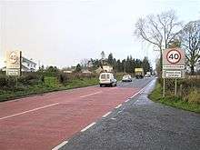
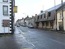
- The A4 is the main route into Fermanagh (and on to County Sligo) from the Belfast direction. Running from the end of the M1 at Dungannon, the section through the Clogher Valley is the lowest standard on the whole route. While towns and villages along the A4 in Fermanagh were generally bypassed years ago, the A4 runs straight through the middle of three Tyrone villages: Augher, Clogher and Fivemiletown. These are now the only non-bypassed settlements on the road. The largest of these, Fivemiletown, will be bypassed. The village currently has a one-way system to cope with the heavy traffic on the narrow main street, but this stalls long-distance traffic and is a big inconvenience to residents of the village. The new road will be built to 2+1 standard, meaning that there will be one lane in one direction, with two in the opposite direction to permit overtaking. On longer routes, such as this one, the overtaking lane usually alternates giving an overtaking opportunity to traffic in each direction. The scheme will compliment a 2+1 scheme completed on the A4 outside Fivemiletown in 2004.[6]
Sport and leisure
- Clogher Valley Golf Club
- Clogher Valley Rugby Football Club
- Fivemiletown United Football Club[7]
Music
- Cavanaleck Pipe Band
- Fivemiletown Accordion Band
- Fivemiletown Pipe Band
- Murley Silver Band
- Pride Of Fivemiletown Flute Band (disbanded)
- Fivemiletown Boyne Defenders (disbanded)
Education
- Fivemiletown Nursery School
- Fivemiletown College
- St. Mary's Primary School
- Fivemiletown Primary School
- Kids R Us Cross Community Playgroup
Religion
- Aghintaine Roman Catholic Church
- Aghintaine Presbyterian Church
- Bell Methodist Church
- Cavanaleck Presbyterian Church
- Clogher Valley Free Presbyterian Church
- Fivemiletown Independent Methodist Church
- Fivemiletown Methodist Church
- Kiltermon Church of Ireland
- St John's Church of Ireland
- St Mary's Roman Catholic Church
Demography
Fivemiletown is classified as a village by the NI Statistics and Research Agency (NISRA) (i.e. with population between 1,000 and 2,250 people). On Census day (29 April 2001) there were 1,108 people living in Fivemiletown. Of these:
- 19.9% were aged under 16 and 20.6% were aged 60 and over
- 48.4% of the population were male and 51.6% were female
- 25.1% were from a Catholic background and 74.0% were from a Protestant background
- 5.6% of people aged 16–74 were unemployed.
References
- ↑ "Bunachar Logainmneacha na hÉireann". Logainm.ie. Retrieved 9 August 2017.
- ↑ Agency, Northern Ireland Statistics and Research. "statistics" (PDF). Ninis.nisra.gov.uk. Retrieved 9 August 2017.
- ↑ "Fivemiletown". Travel.kelkoo.co.uk. Archived from the original on 26 March 2012. Retrieved 8 July 2011.
- ↑ Personal memori
- ↑ "Fivemiletown station" (PDF). Railscot – Irish Railways. Retrieved 14 October 2007.
- ↑ "A4 Fivemiletown Bypass - Northern Ireland Roads Site". Wesleyjohnston.com. Retrieved 9 August 2017.
- ↑ "Fivemiletown United Fc – Grass Roots Football Club". Fivemiletownunitedfc.com. Retrieved 9 August 2017.
External links
| Wikimedia Commons has media related to Fivemiletown. |