Breifne Mountains
| Breifne Mountains | |
|---|---|
|
Cuilcagh Mountains Iron Mountains | |
 Stairway to Cuilcagh, County Fermanagh | |
| Highest point | |
| Peak | Cuilcagh |
| Elevation | 665 m (2,182 ft) |
| Coordinates | 54°12′00″N 7°48′40″W / 54.200°N 7.811°W |
| Naming | |
| Native name | Sléibhte Bréifne |
| Geography | |
| Countries |
Ireland United Kingdom |
| Provinces |
Ulster Connacht |
| Counties | Cavan, Fermanagh and Leitrim |
| Range coordinates | 54°12′00″N 7°48′40″W / 54.200°N 7.811°W |
| Geology | |
| Age of rock | Carboniferous |
| Type of rock | Limestone, Shale, Sandstone |
The Breifne Mountains (Irish: Sléibhte Bréifne), is a range of hills and mountains in counties Cavan, Fermanagh and Leitrim, located in an area historically referred to as the Breifne region. The range has two local sub-ranges - the southern Iron Mountains that span across Leitrim and Cavan, and the northern Cuilcagh Mountains that straddle Cavan and Fermanagh.[1] The highest peak is Cuilcagh at 665 metres (2,182 feet), which is the highest peak in both Cavan and Fermanagh, making it Ireland's only cross-border county top.[2]
Highest Points
The following table lists the 10 highest major mountain peaks of the Breifne Mountains, all with a topographic elevation of at least 411 metres (1,348 ft).
| Rank | Mountain peak | Elevation |
|---|---|---|
| 1 | Cuilcagh | 665 m (2,182 ft) |
| 2 | Sliabh an Iarainn | 585 m (1,919 ft) |
| 3 | Knockacullion | 562 m (1,844 ft) |
| 4 | The Playbank | 542 m (1,778 ft) |
| 5 | Benbeg | 539 m (1,768 ft) |
| 6 | Bencroy | 518 m (1,699 ft) |
| 7 | Benbrack | 502 m (1,647 ft) |
| 8 | Benbrack NE Top | 496 m (1,627 ft) |
| 9 | Benbrack W Top | 463 m (1,519 ft) |
| 10 | Bartonny | 411 m (1,348 ft) |
Other hills
- Slieve Rushen - 404 m (1,325 ft)
- Belmore Mountain - 398 m (1,306 ft)
- Benaughlin Mountain - 373 m (1,224 ft)
See also
References
- ↑ "Mountainviews.ie, Breifne Area". Mountainviews.
- ↑ "Breifne Hills and Mountains". themountainguide.co.uk.
Mountains and hills of Ulster | ||
|---|---|---|
| Antrim Hills | 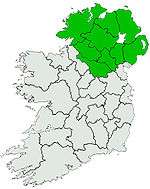 | |
| Antrim Plateau | ||
| Belfast Hills | ||
| Breifne | ||
| Croaghgorms | ||
| Derryveagh | ||
| Inishowen | ||
| Mournes | ||
| Sperrins | ||
| Southwest Donegal | ||
| Others | ||

This article is issued from
Wikipedia.
The text is licensed under Creative Commons - Attribution - Sharealike.
Additional terms may apply for the media files.