Slieve Commedagh
| Slieve Commedagh | |
|---|---|
| Sliabh Coimhéideach | |
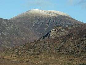 Slieve Commedagh from the south | |
| Highest point | |
| Elevation | 767 m (2,516 ft) [1][2] |
| Prominence | 180 m (590 ft) [1] |
| Listing | Marilyn, Hewitt |
| Coordinates | 54°11′20″N 5°56′19″W / 54.188855°N 5.938667°WCoordinates: 54°11′20″N 5°56′19″W / 54.188855°N 5.938667°W |
| Naming | |
| Translation | mountain of guarding/watching (Irish) |
| Geography | |
| Location | County Down, Northern Ireland |
| Parent range | Mournes |
| OSI/OSNI grid | J346286 |
| Topo map | OSNI Discoverer 29 |
Slieve Commedagh (from Irish: Sliabh Coimhéideach, meaning "the guarding/watching mountain")[3][4] is a mountain with a height of 767 m (2,516 ft) in County Down, Northern Ireland. It is the second-highest of the Mourne Mountains, after Slieve Donard,[1] and the second-highest mountain in Northern Ireland.
Slieve Commedagh lies to the northwest of Slieve Donard, and the two are linked by a col. The Mourne Wall passes east-west over the mountaintop, and there is a small one-room tower at the summit. There is also the remains of an ancient burial cairn on the summit.[1] On its southern side is a group of granite tors known as 'the Castles'.[1]
The Slieve Commedagh massif also includes the summits of Slievecorragh (to the east), Shan Slieve, Slievenamaddy and Slievenabrock (to the north).
Gallery
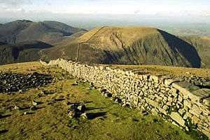 Slieve Commedagh and the Mourne Wall viewed from the top of Slieve Donard
 Slieve Commedagh (middle background) from the south
%2C_February_2010.JPG) Slieve Commedagh (right) viewed from Murlough Beach
Slieve Commedagh (right) viewed from Murlough Beach
See also
References
Mountains and hills of Ulster | ||
|---|---|---|
| Antrim Hills | 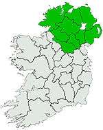 | |
| Antrim Plateau | ||
| Belfast Hills | ||
| Breifne | ||
| Croaghgorms | ||
| Derryveagh | ||
| Inishowen | ||
| Mournes | ||
| Sperrins | ||
| Southwest Donegal | ||
| Others | ||