Castlecaulfield
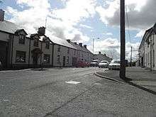

Castlecaulfield is a small village in County Tyrone, Northern Ireland. It lies about 2 miles west of Dungannon and is part of the Mid Ulster District Council area. The village is mostly within the townland of Drumreany, although part of it extends into Lisnamonaghan. It is situated in the historic barony of Dungannon Middle and the civil parish of Donaghmore.[1] It is sometimes called "Caufle" or "Cawfield" by locals.[2] The village came Joint First in the Britain in Bloom (Village Category) in 2016 and first in the Ulster in Bloom (Village Category)in 2015 & 2016.
History
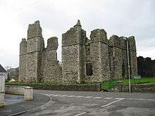
The village came into being during the Plantation of Ulster in an area formerly known as Ballydonnelly. Formerly part of the O'Donnghaile clan's territory, it was "undertaken" by English settlers. The Castle to which the name refers was in the main square and was built to protect the local population from Irish attacks. It was built by Toby Caulfield, Viscount Charlemont. The remains of George Walker are buried within the local parish church. Walker was the governor in the city of Londonderry during the 1689 Siege of Derry.
Places of interest
- The ruins of Castle Caulfield, built by Sir Toby Caulfield between 1611 and 1619 are in the village. The gatehouse has murder-holes and the Caulfeild arms.
- Oliver Plunkett and John Wesley both preached in the old castle at various times.
- Parkanaur House, a Tudor revival country house.
- There is a plaque to poet Charles Wolfe (1791–1823), author of 'The Burial of Sir John Moore' at St Michael's, the local Church of Ireland.
Events
- Castlecaulfield Horticultural Society hold a show every year in August to which people are encouraged to enter horticultural and handicraft items for prizes. The society also holds fundraising events throughout the year to support its yearly show.
People
- Schools rugby coach David Wells (Methodist College) came from Castlecaulfield.
Demography
19th century population
The population of the village increased slightly overall during the 19th century:[3][4]
| Year | 1841 | 1851 | 1861 | 1871 | 1881 | 1891 |
|---|---|---|---|---|---|---|
| Population | 167 | 172 | 208 | 185 | 220 | 170 |
| Houses | 37 | 45 | 43 | 37 | 38 | 40 |
References
- ↑ "Townlands of County Tyrone". IreAtlas Townland Database. Retrieved 17 May 2016.
- ↑ Forest Recreation in Norlin Airlan Archived 2013-04-23 at Archive.is Department of Agriculture and Rural Development.
- ↑ "Census of Ireland 1851". Enhanced Parliamentary Papers on Ireland. Retrieved 22 March 2013.
- ↑ "Census of Ireland 1891". Enhanced Parliamentary Papers on Ireland. Retrieved 22 March 2013.
- Dungannon & South Tyrone Area Plan 2010
External links
| Wikimedia Commons has media related to Castlecaulfield. |
- Castlecaulfield Horticultural Society
- Castlecaulfield Community Website Parked
- Environment and Heritage Service - St Michael's Church WebEngine error: Page not found!
- Library Ireland