Derryveagh Mountains
| Derryveagh Mountains | |
|---|---|
| Irish: Cnoic Dhoire Bheatha | |
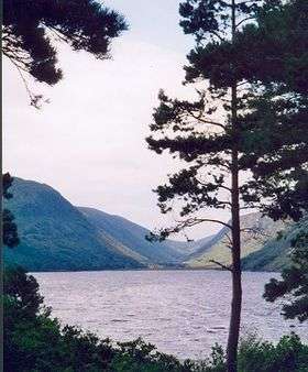 Loch Ghleann Bheatha in the grounds of the castle at Gleann Bheatha | |
| Highest point | |
| Elevation | 751 m (2,464 ft) |
| Coordinates | 55°01′N 8°03′W / 55.017°N 8.050°WCoordinates: 55°01′N 8°03′W / 55.017°N 8.050°W |
| Geography | |
| Country | Republic of Ireland |
| Provinces of Ireland | Ulster |

The Poisoned Glen from the R251 road, County Donegal.
The Derryveagh Mountains (Irish: Cnoic Dhoire Bheatha) are the major mountain range in County Donegal, Ireland. It makes up much of the landmass of the county, and is the area of Ireland with the lowest population density. The mountains separate the coastal parts of the county, such as Gweedore and Glenties, from the major inland towns such as Ballybofey and Letterkenny. Its highest peak is Mount Errigal.[1]
References
- ↑ "The mystery of the Poisoned Glen". Monreagh Heritage Centre. Retrieved 4 September 2016.
See also
Mountains and hills of Ulster | ||
|---|---|---|
| Antrim Hills | 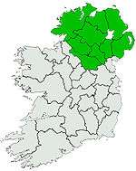 | |
| Antrim Plateau | ||
| Belfast Hills | ||
| Breifne | ||
| Croaghgorms | ||
| Derryveagh | ||
| Inishowen | ||
| Mournes | ||
| Sperrins | ||
| Southwest Donegal | ||
| Others | ||
This article is issued from
Wikipedia.
The text is licensed under Creative Commons - Attribution - Sharealike.
Additional terms may apply for the media files.