Shire of Cook
| Shire of Cook Queensland | |||||||||||||||
|---|---|---|---|---|---|---|---|---|---|---|---|---|---|---|---|
 Location within Queensland | |||||||||||||||
| Coordinates | Coordinates: 15°28′05.4″S 145°15′02″E / 15.468167°S 145.25056°E | ||||||||||||||
| Population | 4,226 (2016 census)[1] | ||||||||||||||
| • Density | 0.039797/km2 (0.103074/sq mi) | ||||||||||||||
| Established | 1919 | ||||||||||||||
| Area | 106,188.4 km2 (40,999.6 sq mi) | ||||||||||||||
| Mayor | Peter Scott | ||||||||||||||
| Council seat | Cooktown | ||||||||||||||
| Region | Far North Queensland | ||||||||||||||
| State electorate(s) | Cook | ||||||||||||||
| Federal Division(s) | Leichhardt | ||||||||||||||
 | |||||||||||||||
| Website | Shire of Cook | ||||||||||||||
| |||||||||||||||
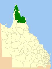
The Shire of Cook is a local government area in Far North Queensland, Australia. The Shire covers most of the eastern and central parts of Cape York Peninsula, the most northerly section of the Australian mainland.
It covers an area of 106,188.4 square kilometres (40,999.6 sq mi), and has existed as a local government entity since 1919.
History
The Daintree and Hann Divisions were created on 11 November 1879 as two of 74 divisions around Queensland under the Divisional Boards Act 1879.[2][3]
With the passage of the Local Authorities Act 1902, they became the Shires of Daintree and Hann on 31 March 1903.[2][3][4][5]
On 16 January 1919, they merged to form the Shire of Cook.[4][5][6]
The Borough of Cooktown was proclaimed as a separate municipality on 3 April 1876 under the Municipal Institutions Act 1864. On 24 August 1932, the Town of Cooktown (the successor to the Borough of Cooktown) was absorbed back into Cook Shire.[6][7]
Prior to 2005, a number of Aboriginal communities administered under Deed of Grant in Trust by community councils were part of the Shire's area, but they were formally excised and given a new status as Aboriginal Shires. This formed part of the Meeting Challenges, Making Choices strategy developed in response to the Cape York Justice Study undertaken by Justice Fitzgerald QC in November 2001.[8]
The Local Government Reform process in July 2007 concluded that amalgamation of the Shire would not result in any benefits to service delivery and management for the area, noting that it was (and is) the largest local government by area and had no community of interest with any neighbouring areas. The council was, however, reduced from seven to six councillors with an additional elected mayor.[9]
Towns and localities
The Shire of Cook includes the following settlements:
|
|
1 – shared with the Shire of Douglas
2 – shared with the Aboriginal Shire of Hope Vale
3 – shared with the Aboriginal Shire of Lockhart River
4 – shared with the Aboriginal Shire of Mapoon
And also a number of islands in the Coral Sea, including:
- Raine Island
- Lizard Island (in the locality of Lizard)
Libraries
The Cook Shire Council operate public libraries at Bloomfield and Cooktown.[10]
Chairmen and mayors
Population
The population of the Shire of Cook, along with Torres, Aurukun and Mornington, have been singled out by the Australian Bureau of Statistics (ABS), who conduct the quinquennial census, as particularly difficult to measure accurately. Reasons for this include cultural and language barriers, transport and geographical spread of the population, who are mostly located in isolated communities. As such, all figures are likely to be lower than the actual population on the census date. Additionally, prior to 1971, Aboriginal people who form a majority of the population were not counted in census statistics.
Until 1 July 2002, the Australian Bureau of Statistics included the Island and DOGIT councils within the Shire of Cook statistical local area. Information for the reduced Shire back to 1996 has been provided on the ABS website through the Time Series Profile.
| Year | Population |
|---|---|
| 1933 | 2,068 |
| 1947 | 1,139 |
| 1954 | 1,545 |
| 1961 | 1,869 |
| 1966 | 2,463 |
| 1971 | 5,538 |
| 1976 | 6,128 |
| 1981 | 4,456 |
| 1986 | 4,776 |
| 1991 | 8,785 |
| 1996 | 5,232 |
| 2001 | 4,776 |
| 2006 | 4,653 |
| 2011 | 4,152 |
| 2016 | 4,226 |
References
- ↑ Australian Bureau of Statistics (27 June 2017). "Cook (S)". 2016 Census QuickStats. Retrieved 26 November 2017.

- 1 2 "Agency ID813, Daintree Divisional Board". Queensland State Archives. Retrieved 10 September 2013.
- 1 2 "Agency ID936, Hann Divisional Board". Queensland State Archives. Retrieved 10 September 2013.
- 1 2 "Agency ID814, Daintree Shire Council". Queensland State Archives. Retrieved 10 September 2013.
- 1 2 "Agency ID937, Hann Shire Council". Queensland State Archives. Retrieved 10 September 2013.
- 1 2 "Agency ID603, Cook Shire Council". Queensland State Archives. Retrieved 10 September 2013.
- ↑ "Order in Council". Queensland Government Gazette. 6 August 1932. p. 138:400.
- ↑ McDougall, Scott (January 2006). Palm Island: Future Directions – Resource Officer Report (PDF). Brisbane, Queensland: Queensland Department of Aboriginal and Torres Strait Islander Policy. p. 27. Archived from the original (PDF) on 7 July 2007.
- ↑ Queensland Local Government Reform Commission (July 2007). Report of the Local Government Reform Commission (PDF). 2. pp. 93–96. ISBN 1-921057-11-4. Retrieved 17 September 2009.
- ↑ "Cook Shire Council Libraries Service". Public Libraries Connect. State Library of Queensland. 20 September 2016. Retrieved 2 February 2018.
- ↑ Hargreaves, John Henry – Queensland Parliament. Retrieved 15 May 2016.
- ↑ Pugh, Theophilus Parsons (1927). Pugh's Almanac for 1927. Retrieved 13 June 2014.
- ↑ "Mayor Peter Scott". Cook Shire. Cook Shire Council. Archived from the original on 15 June 2014. Retrieved 15 June 2014.
- ↑ "2008 Cook Shire – Mayoral Election – Election Summary". results.ecq.qld.gov.au. Retrieved 4 December 2017.
- ↑ "2012 Cook Shire – Mayoral Election – Election Summary". results.ecq.qld.gov.au. Retrieved 4 December 2017.
- ↑ "2016 Cook Shire Council – Mayoral Election – Election Summary". results.ecq.qld.gov.au. Retrieved 4 December 2017.