Kuranda, Queensland
| Kuranda Queensland | |||||||||||||||
|---|---|---|---|---|---|---|---|---|---|---|---|---|---|---|---|
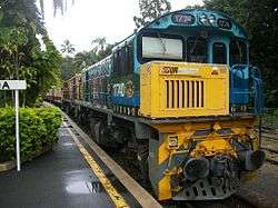
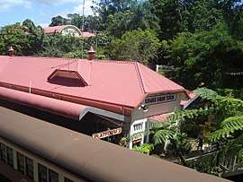 Kuranda railway station with scenic rail on the left | |||||||||||||||
 Kuranda | |||||||||||||||
| Coordinates | 16°49′S 145°38′E / 16.817°S 145.633°ECoordinates: 16°49′S 145°38′E / 16.817°S 145.633°E | ||||||||||||||
| Population | 3,008 (2016 census)[1] | ||||||||||||||
| Established | 1888 | ||||||||||||||
| Postcode(s) | 4881 | ||||||||||||||
| Elevation | 330 m (1,083 ft) | ||||||||||||||
| LGA(s) | Shire of Mareeba | ||||||||||||||
| State electorate(s) | Barron River | ||||||||||||||
| Federal Division(s) | Leichhardt | ||||||||||||||
| |||||||||||||||
Kuranda is a town and locality on the Atherton Tableland in the Shire of Mareeba, Far North Queensland, Australia.[2][3] The town of Myola is also located within the locality of Kuranda.[4] It is 25 kilometres (16 mi) from Cairns, via the Kuranda Range road. It is surrounded by tropical rainforest and adjacent to the Wet Tropics World Heritage listed Barron Gorge National Park. It is within the local government area of Shire of Mareeba (between 2008 and 2013, it was within the Tablelands Region).
Geography
Kuranda is positioned on the eastern edge of the Atherton Tableland where the Barron River begins a steep descent to its coastal floodplain. The area is an important wildlife corridor between the Daintree/Carbine Tableland area in the north and Lamb Range/Atherton Tableland in the south, two centres of biodiversity.[5]
Parts of Kuranda, particularly along its eastern edge, are protected within the Kuranda National Park and Barron Gorge National Park. Both national parks belong to the Wet Tropics World Heritage Area. Barron Gorge Forest Reserve and Formatine Forest Reserve have been established in the south of Kuranda. Closer to the centre of the town is Jumrum Creek Conservation Park where a near threatened, endemic frog species is protected.[6] An elongated dam created by a weir built for a power station was constructed in 1935 and is used to today for recreation.
History
The rainforest around Kuranda has been home to the Djabugay people for over 10,000 years. Europeans began to explore the area throughout the nineteenth century. It is believed a massacre of indigenous people took place at the location in Kuranda known as Skeleton Creek. Kuranda was first settled in 1885 and surveyed by Thomas Behan in 1888. Construction of the railway from Cairns to Myola (later Cairns to Herberton) began in 1887 and the line reached Kuranda in 1891. The current railway station was built in 1915.
Kuranda Post Office opened on 25 June 1891 (a Middle Crossing receiving office had been open from 1888).[7] Between 1912 and 1913 Eric Mjöberg lead an expedition to Queensland in which the Kuranda Aboriginal people were observed.[8]
Kuranda District State School and Kuranda State High School amalgamated at the commencement of 2007 to create Kuranda District State College.[9][10]
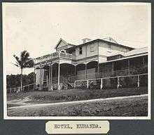
Although coffee was grown around Kuranda in the early twentieth century, timber was the town's primary industry for a number of years. Kuranda has been known as a tourist destination since the early 1900s.[8] It was both the rainforest and local Aboriginals which attracted people to the area. Today Kuranda is a 'village in the rainforest' with tourism being the current backbone of the local economy. The 'village in the rainforest' concept promoted from the 1970s onwards served two purposes. It attracted those seeking a bohemian enclave in which to reside as well as a being a tourist promotional strategy.[8] Throughout the 1970s and 1980s Kuranda was popular with alternative lifestylers,[8] a theme that still runs through the local community today.
The Barron Gorge Hydroelectric Power Station was built nearby in the 1960s.
Kuranda Library opened in 1996 and underwent a major refurbishment in 2015.[11]
At the 2011 census, the locality Kuranda had a population of 2,966.[12]
Heritage listings
Kuranda has a number of heritage-listed sites:
- Cairns-to-Kuranda railway line (operated as the Kuranda Scenic Railway) including the Kuranda railway station.[13]
Tourism
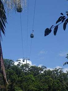

The town receives thousands of tourists each week who arrive from Cairns either on the Kuranda Scenic Railway, the Skyrail Rainforest cableway, coach or by public bus via the Kuranda Range Road, which is a 40-minute drive from Cairns.
The town is surrounded by tropical rainforest which is abundant with wildlife and popular amongst birdwatchers. There are several short walks around the village including the Jum Rum Creek Environmental Park which includes The River Walk. Walking to the Barron Gorge National Park to visit Barron Falls is also popular. Another 1 kilometre (0.62 mi) each way on to Wright's Lookout. There is also a shuttle service that provides an alternative to walking with a half-hourly service out to the Barron Gorge National Park. This service also includes a visit to Wright's Lookout. (Note Sept 2014 - this shuttle bus is no longer running.)
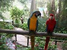
Attractions in Kuranda include a bird aviary, butterfly sanctuary, wildlife rescue/rehabilitation centre, reptile park and koala sanctuary. There is also a fossil and gemstone museum and candy making displays. Cruises are available aboard 'Kuranda Queen' on the Barron River.
Kuranda provides the visitor with many shopping opportunities, all within easy walking distance around the CBD, including the markets which consist of a range of stalls with locally made arts, crafts and produce. Kuranda has numerous art galleries and specialty shops offering a wide selection of locally made and designed art, clothing and handicrafts as well as a variety of sidewalk cafes and restaurants. Kuranda is also a major centre for opals and didgeridoos.
It was also the first home of the Tjapukai Indigenous Dance Theatre, established by former New Yorkers Judy and Don Freeman, together with indigenous dancer and actor, David Hudson. The theatre is now located adjacent the Skyrail Terminal at Smithfield.
Amenities
Mareeba Shire Council operate a public library in Kuranda at 18-22 Arara Street.[14]
The Kuranda Historical Society was established in 2017 and seeks to collect and display items of historical interest relating to the Kuranda area.[15]
The Kuranda Media Association publish a monthly newspaper called "The Kuranda Paper".[16]
Education
Kuranda District State School and Kuranda State High School amalgamated in 2007 to form Kuranda District State College. [17]
Fauna
The nocturnal frog species Litoria myola is only found in the vicinity of a few creeks near Kuranda.[18] The area boasts a rich diversity of invertebrate fauna including Australia's largest species of mantids, phasmids, spiders, moths and butterflies all found in Kuranda.
Weather
Being situated in the tropics, Kuranda experiences only mild variations in temperature and its seasons consist of a dry season and a wet season.
Kuranda does not seem to have a dedicated weather station and resultant data feed. It appears that phone and weather apps default to Cairns data and so can be misleading.
Generally Kuranda is 2–5 °C cooler than Cairns, it has more rainy days as a result of orographic influences, and it is more humid generally (with residential areas in Kuranda village averaging 90% relative humidity, because of the surrounding rain-forest). Kuranda is often referred to the "air conditioned suburb of Cairns" and the rain-forest and elevation is responsible in part for these perceptions. It is rare for the temperature to exceed 31 °C in summer, the weather being moderated by rain and cloud cover in January to March (the wet season), and night minimums at this time of year similarly rarely drop below 20 °C. Winter maximums (June to August) are typically a consistent 25 °C; however, minimums can drop to 8 °C, owing to clear skies at this time of year and cooler air movements originating from the southern Atherton Tablelands.
Government
Kuranda is located in the (federal) Australian House of Representatives Division of Leichhardt, the Legislative Assembly of Queensland Electoral district of Barron River and locally, in the Shire of Mareeba.
References
- ↑ Australian Bureau of Statistics (27 June 2017). "Kuranda (State Suburb)". 2016 Census QuickStats. Retrieved 23 January 2018.

- ↑ "Kuranda - town (entry 18634)". Queensland Place Names. Queensland Government. Retrieved 9 April 2016.
- ↑ "Kuranda - locality (entry 48714)". Queensland Place Names. Queensland Government. Retrieved 9 April 2016.
- ↑ "Myola - town (entry 23727)". Queensland Place Names. Queensland Government. Retrieved 9 April 2016.
- ↑ "About Kuranda and Mowbray". Department of National Parks, Recreation, Sport and Racing. 7 November 2012. Archived from the original on 26 August 2014. Retrieved 24 August 2014.
- ↑ "Jumrum Creek Conservation Park: Nature, culture, history". Department of National Parks, Recreation, Sport and Racing. 21 December 2012. Archived from the original on 26 August 2014. Retrieved 24 August 2014.
- ↑ Premier Postal History. "Post Office List". Premier Postal Auctions. Archived from the original on 15 May 2014. Retrieved 10 May 2014.
- 1 2 3 4 Henry, Rosita (2012). Performing Place, Practising Memories: Aboriginal Australians, Hippies and the State. Berghahn Books. pp. 6–9. ISBN 0857455095. Retrieved 24 August 2014.
- ↑ "Kuranda District State College". Archived from the original on 4 February 2017. Retrieved 31 January 2017.
- ↑ "Schools opening dates". Archived from the original on 11 August 2017. Retrieved 31 January 2017.
- ↑ "Public Libraries Statistical Bulletin 2016-17" (PDF). Public Libraries Connect. State Library of Queensland. November 2017. p. 14. Archived (PDF) from the original on 30 January 2018. Retrieved 30 January 2018.
- ↑ Australian Bureau of Statistics (31 October 2012). "Kuranda (State Suburb)". 2011 Census QuickStats. Retrieved 24 August 2014.
- ↑ "Cairns Railway, Section from Redlynch to Crooked Creek Bridge (entry 600755)". Queensland Heritage Register. Queensland Heritage Council. Retrieved 14 July 2013.
- ↑ "Kuranda Library". Public Libraries Connect. State Library of Queensland. 21 October 2015. Archived from the original on 17 March 2018. Retrieved 2 February 2018.
- ↑ "Kuranda History Group". Archived from the original on 12 April 2018. Retrieved 12 April 2018.
- ↑ Kuranda Media Association. "Kuranda Paper". www.kurandapaper.com. Archived from the original on 23 March 2018. Retrieved 26 April 2018.
- ↑ "Opening and closing dates of Queensland schools". Education Queensland. 1 August 2013. Archived from the original on 11 August 2017. Retrieved 3 February 2018.
- ↑ Vanderduys, Eric (2012). Field Guide to the Frogs of Queensland. Csiro Publishing. p. 55. ISBN 0643106308. Retrieved 24 August 2014.
External links
| Wikimedia Commons has media related to Kuranda, Queensland. |
| Wikivoyage has a travel guide for Kuranda. |
- Queensland Places: Kuranda
- Kuranda - Village in the Rainforest
- Track in the forest - The Sydney Morning Herald: Traveller